
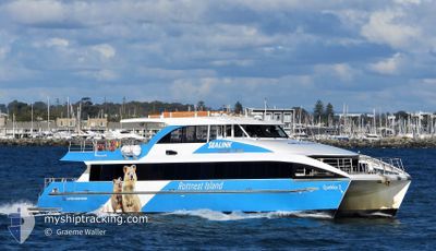
MV MAGGIE CAT
Passenger
Current Trip
| Time Travelled | 20 mins |
|---|---|
| Remaining Time | 10 mins |
| Distance Travelled | 2.87 nm |
| Remaining Distance | 9.40 nm |
| AVG Speed | --- |
| MAX Speed | --- |
| AVG Wind | 4.5 knots |
| MAX Wind | 4.8 knots |
| MIN Temp | 29.4°C / 84.92°F |
| MAX Temp | 29.4°C / 84.92°F |
| Tirant d eau | 1.2 m |
| Position reçue | 12 m depuis |
Current Position
| Longitude | --- |
|---|---|
| Latitude | --- |
| Etat | Under way using engine |
| Vitesse | 22.2 Noeuds |
| Parcours | 291.4° |
| Zone | Indian Ocean |
| Station | T-AIS |
| Position reçue | 12 m depuis |
Info
Information
The current position of MV MAGGIE CAT is in Indian Ocean with coordinates -32.04072° / 115.66997° as reported on 2025-02-17 05:28 by AIS to our vessel tracker app. The vessel's current speed is 22.2 Noeuds and is heading at the port of ROTTNEST ISLAND. The estimated time of arrival as calculated by MyShipTracking vessel tracking app is 2025-02-17 05:50 LT
The vessel MV MAGGIE CAT (IMO: 9447134, MMSI: 503260900) is a Passenger It's sailing under the flag of [AU] Australia.
In this page you can find informations about the vessels current position, last detected port calls, and current voyage information. If the vessels is not in coverage by AIS you will find the latest position.
The current position of MV MAGGIE CAT is detected by our AIS receivers and we are not responsible for the reliability of the data. The last position was recorded while the vessel was in Coverage by the Ais receivers of our vessel tracking app.
The current draught of MV MAGGIE CAT as reported by AIS is 1.2 meters
Weather
| Temperature | 29.5°C / 85.1°F |
|---|---|
| Wind Speed | 4 knots |
| Direction | 180° S |
| Pressure | 1010.4 hPa |
| Humidity | 36.8 % |
| Cloud Coverage | 71 % |
Featured Company
Last Port Calls
| Port | Arrival | Departure | Time In Port |
|---|---|---|---|
| 2025-02-17 05:20 | |||
| 2025-02-17 04:58 | |||
| 2025-02-17 04:58 | |||
| 2025-02-17 03:20 | |||
| 2025-02-17 03:04 | 2025-02-17 03:12 | 8 m | |
| 2025-02-17 02:02 | 2025-02-17 02:33 | 31 m | |
| 2025-02-16 09:58 | 2025-02-17 00:44 | 14 h | |
| 2025-02-16 09:08 | 2025-02-16 09:15 | 7 m | |
| 2025-02-16 05:51 | 2025-02-16 08:33 | 2 h | |
| 2025-02-16 05:08 | 2025-02-16 05:17 | 9 m |
Most Visited Ports (Last year)
| Port | Arrivals | |
|---|---|---|
| 940 | ||
| 676 | ||
| 286 | ||
| 136 |
Last Trips
| Origin | Departure | Destination | Arrival | Distance | |
|---|---|---|---|---|---|
| 2025-02-17 12:58 | 2025-02-17 12:58 | --- | |||
| 2025-02-17 11:12 | 2025-02-17 11:20 | 0.48 nm | |||
| 2025-02-17 10:33 | 2025-02-17 11:04 | 9.78 nm | |||
| 2025-02-17 08:44 | 2025-02-17 10:02 | 19.73 nm | |||
| 2025-02-16 17:15 | 2025-02-16 17:58 | 8.20 nm | |||
| 2025-02-16 16:33 | 2025-02-16 17:08 | 11.10 nm | |||
| 2025-02-16 13:17 | 2025-02-16 13:51 | 10.36 nm | |||
| 2025-02-16 12:53 | 2025-02-16 13:08 | 0.03 nm | |||
| 2025-02-16 10:32 | 2025-02-16 11:20 | 3.56 nm | |||
| 2025-02-16 08:39 | 2025-02-16 10:05 | 19.39 nm |
Events
| Heure | Evenement | Détails | Position/ Destination | Info |
|---|---|---|---|---|
| 2025-02-17 05:20 | PORT DE DEPART |
|
-32.05512 / 115.72342
ROTTNEST
|
Vitesse: 10.1 kn Parcours: 239° |
| 2025-02-17 05:17 | Démarrage |
-32.05314 / 115.73887
[AU] FREMANTLE
|
Vitesse: 10.1 kn Parcours: 239° |
|
| 2025-02-17 04:59 | Arret |
-32.05255 / 115.74220
[AU] FREMANTLE
|
Vitesse: 0.2 kn Parcours: 232° |
|
| 2025-02-17 04:58 | PORT DE DEPART |
|
-32.05217 / 115.74201
ROTTNEST
|
Vitesse: 9 kn Parcours: 194° |
| 2025-02-17 04:58 | Port d'arrivée |
|
-32.05217 / 115.74201
[AU] FREMANTLE
|
Vitesse: 9 kn Parcours: 194° |
| 2025-02-17 04:53 | Démarrage |
-32.05113 / 115.72961
[AU] NORTH FREMANTLE
|
Vitesse: 8.3 kn Parcours: 215° |
|
| 2025-02-17 04:50 | Etat Changé | Under way using engine Default |
-32.04858 / 115.73199
[AU] NORTH FREMANTLE
|
Vitesse: Parcours: 20° |
| 2025-02-17 04:50 | Dans la zone couverte |
-32.05161 / 115.72915
Indian Ocean
[AU] NORTH FREMANTLE
|
Vitesse: 8.5 kn Parcours: 216.4° |
|
| 2025-02-17 03:21 | Etat Changé | Default Under way using engine |
-32.04802 / 115.73247
[AU] NORTH FREMANTLE
|
Vitesse: 3.4 kn Parcours: 35° |
| 2025-02-17 03:16 | Hors de la zone couverte |
-32.04816 / 115.73236
Indian Ocean
[AU] NORTH FREMANTLE
|
Vitesse: 3.4 kn Parcours: 29.8° |