
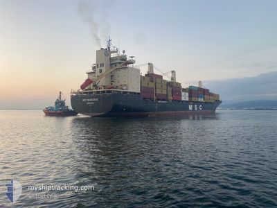
MSC MADISON II
General Cargo
Current Trip
| Time Travelled | 40 mins |
|---|---|
| Remaining Time | 11 h, 52 mins |
| Distance Travelled | 6.68 nm |
| Remaining Distance | 143.74 nm |
| AVG Speed | 12 Noeuds |
| MAX Speed | 12.1 Noeuds |
| AVG Wind | 13.8 knots |
| MAX Wind | 14.3 knots |
| MIN Temp | 25.3°C / 77.54°F |
| MAX Temp | 25.4°C / 77.72°F |
| Tirant d eau | 10.1 m |
| Position reçue | Maintenant |
Current Position
| Longitude | 13.62726° |
|---|---|
| Latitude | 43.69501° |
| Etat | Under way using engine |
| Vitesse | 12.1 Noeuds |
| Parcours | 59.5° |
| Zone | Adriatic Sea |
| Station | T-AIS |
| Position reçue | Maintenant |
Info
Information
The current position of MSC MADISON II is in Adriatic Sea with coordinates 43.69501° / 13.62726° as reported on 2024-09-09 20:59 by AIS to our vessel tracker app. The vessel's current speed is 12.1 Noeuds and is heading at the port of TRIESTE. The estimated time of arrival as calculated by MyShipTracking vessel tracking app is 2024-09-10 08:52 LT
The vessel MSC MADISON II (IMO: 9231119, MMSI: 636021596) is a General Cargo that was built in 2002 ( 22 Age ). It's sailing under the flag of [LR] Liberia.
In this page you can find informations about the vessels current position, last detected port calls, and current voyage information. If the vessels is not in coverage by AIS you will find the latest position.
The current position of MSC MADISON II is detected by our AIS receivers and we are not responsible for the reliability of the data. The last position was recorded while the vessel was in Coverage by the Ais receivers of our vessel tracking app.
The current draught of MSC MADISON II as reported by AIS is 10.1 meters
Weather
| Temperature | 25.3°C / 77.54°F |
|---|---|
| Wind Speed | 10 knots |
| Direction | 347° NNW |
| Pressure | 1003.9 hPa |
| Humidity | 67 % |
| Cloud Coverage | --- |
Featured Company
Last Port Calls
| Port | Arrival | Departure | Time In Port |
|---|---|---|---|
| 2024-09-09 12:09 | 2024-09-09 20:20 | 8 h | |
| 2024-09-07 06:44 | 2024-09-08 05:44 | 22 h | |
| 2024-09-05 20:43 | 2024-09-06 22:25 | 1 d | |
| 2024-09-02 07:24 | 2024-09-03 18:53 | 1 d | |
| 2024-08-29 15:33 | 2024-08-31 01:45 | 1 d | |
| 2024-08-26 19:46 | 2024-08-27 16:20 | 20 h | |
| 2024-08-24 17:47 | 2024-08-25 04:18 | 10 h | |
| 2024-08-23 04:25 | 2024-08-23 20:44 | 16 h | |
| 2024-08-22 05:34 | 2024-08-22 21:51 | 16 h | |
| 2024-08-17 12:55 | 2024-08-20 03:40 | 2 d |
Last Trips
| Origin | Departure | Destination | Arrival | Distance | |
|---|---|---|---|---|---|
| 2024-09-08 07:44 | 2024-09-09 14:09 | 113.54 nm | |||
| 2024-09-07 00:25 | 2024-09-07 08:44 | 83.87 nm | |||
| 2024-09-03 20:53 | 2024-09-05 22:43 | 677.66 nm | |||
| 2024-08-31 03:45 | 2024-09-02 09:24 | 155.32 nm | |||
| 2024-08-27 18:20 | 2024-08-29 17:33 | 577.17 nm | |||
| 2024-08-25 06:18 | 2024-08-26 21:46 | 157.17 nm | |||
| 2024-08-23 22:44 | 2024-08-24 19:47 | 19.89 nm | |||
| 2024-08-22 23:51 | 2024-08-23 06:25 | 75.83 nm | |||
| 2024-08-20 05:40 | 2024-08-22 07:34 | 680.36 nm | |||
| 2024-08-15 06:21 | 2024-08-17 14:55 | 694.77 nm |
Events
| Heure | Evenement | Détails | Position/ Destination | Info |
|---|---|---|---|---|
| 2024-09-09 20:28 | Tirant d'eau modifié | 10.1 9.9 |
43.64386 / 13.50483
ITTRS
|
Vitesse: 10.1 kn Parcours: 62.8° |
| 2024-09-09 20:28 | Changement de destination | ITTRS ITAOI |
43.64386 / 13.50483
ITTRS
|
Vitesse: 10.1 kn Parcours: 62.8° |
| 2024-09-09 20:28 | Changement d'ETA | 2024/09/10 14:00 2024/09/08 14:00 |
43.64386 / 13.50483
ITTRS
|
Vitesse: 10.1 kn Parcours: 62.8° |
| 2024-09-09 20:20 | PORT DE DEPART |
|
43.63337 / 13.48896
ITAOI
|
Vitesse: 6 kn Parcours: 340° |
| 2024-09-09 20:15 | Démarrage |
43.62830 / 13.49226
[IT] ANCONA
|
Vitesse: 3.5 kn Parcours: 1° |
|
| 2024-09-09 20:08 | Etat Changé | Under way using engine Default |
43.62353 / 13.49355
[IT] ANCONA
|
Vitesse: Parcours: 212° |
| 2024-09-09 19:59 | Dans la zone couverte |
43.62362 / 13.49355
Adriatic Sea
[IT] ANCONA
|
Vitesse: 0.3 kn Parcours: 136° |
|
| 2024-09-09 12:30 | Arret |
43.62052 / 13.49288
[IT] ANCONA
|
Vitesse: 0.1 kn Parcours: 212° |
|
| 2024-09-09 12:17 | Etat Changé | Default Under way using engine |
43.62187 / 13.49340
[IT] ANCONA
|
Vitesse: 5.7 kn Parcours: 166° |
| 2024-09-09 12:13 | Hors de la zone couverte |
43.62651 / 13.49263
Adriatic Sea
[IT] ANCONA
|
Vitesse: 5.7 kn Parcours: 165° |