
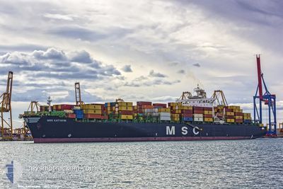
MSC KATYAYNI
Container Ship
Current Trip
| Trip Time | 15 h, 24 mins |
|---|---|
| Trip Distance | 153.31 nm |
| AVG Speed | 11.9 Noeuds |
| MAX Speed | 15.2 Noeuds |
| Tirant d eau | 14.5 m |
| AVG Wind | 7.4 knots |
| MAX Wind | 10.3 knots |
| MIN Temp | 25.8°C / 78.44°F |
| MAX Temp | 34.1°C / 93.38°F |
| Position reçue | 9 d depuis |
Current Position
| Longitude | --- |
|---|---|
| Latitude | --- |
| Etat | Under way using engine |
| Vitesse | 16.4 Noeuds |
| Parcours | 176.3° |
| Zone | North Atlantic Ocean |
| Station | T-AIS |
| Position reçue | 9 d depuis |
Info
Information
The current position of MSC KATYAYNI is in North Atlantic Ocean with coordinates 14.69457° / -17.93597° as reported on 2024-11-22 16:39 by AIS to our vessel tracker app. The vessel's current speed is 16.4 Noeuds and is currently inside the port of LAGOS.
The vessel MSC KATYAYNI (IMO: 9110389, MMSI: 351675000) is a Container Ship that was built in 1996 ( 28 Age ). It's sailing under the flag of [PA] Panama.
In this page you can find informations about the vessels current position, last detected port calls, and current voyage information. If the vessels is not in coverage by AIS you will find the latest position.
The current position of MSC KATYAYNI is detected by our AIS receivers and we are not responsible for the reliability of the data. The last position was recorded while the vessel was in Coverage by the Ais receivers of our vessel tracking app.
The current draught of MSC KATYAYNI as reported by AIS is 14.5 meters
Weather
| Temperature | --- |
|---|---|
| Wind Speed | --- |
| Direction | --- |
| Pressure | --- |
| Humidity | --- |
| Cloud Coverage | --- |
Featured Company
Last Port Calls
| Port | Arrival | Departure | Time In Port |
|---|---|---|---|
| 2024-12-01 07:12 | |||
| 2024-11-29 02:40 | 2024-11-30 15:48 | 1 d | |
| 2024-11-15 19:20 | 2024-11-16 20:40 | 1 d | |
| 2024-11-13 02:36 | 2024-11-14 23:27 | 1 d | |
| 2024-11-09 08:42 | 2024-11-09 21:34 | 12 h | |
| 2024-11-08 01:09 | 2024-11-08 14:37 | 13 h | |
| 2024-10-26 22:05 | 2024-10-28 03:22 | 1 d | |
| 2024-10-24 07:09 | 2024-10-25 03:10 | 20 h | |
| 2024-10-20 13:09 | 2024-10-20 23:45 | 10 h | |
| 2024-10-18 14:21 | 2024-10-20 06:53 | 1 d |
Last Trips
| Origin | Departure | Destination | Arrival | Distance | |
|---|---|---|---|---|---|
| 2024-11-30 15:48 | 2024-12-01 08:12 | 153.31 nm | |||
| 2024-11-16 21:40 | 2024-11-29 02:40 | 4012.33 nm | |||
| 2024-11-15 00:27 | 2024-11-15 20:20 | 272.29 nm | |||
| 2024-11-09 22:34 | 2024-11-13 03:36 | 289.72 nm | |||
| 2024-11-08 14:37 | 2024-11-09 09:42 | 127.19 nm | |||
| 2024-10-28 03:22 | 2024-11-08 01:09 | 3786.28 nm | |||
| 2024-10-25 03:10 | 2024-10-26 22:05 | 216.17 nm | |||
| 2024-10-21 00:45 | 2024-10-24 07:09 | 585.55 nm | |||
| 2024-10-20 07:53 | 2024-10-20 14:09 | 85.45 nm | |||
| 2024-10-18 03:45 | 2024-10-18 15:21 | 151.21 nm |
Events
| Heure | Evenement | Détails | Position/ Destination | Info |
|---|---|---|---|---|
| 2024-12-01 07:29 | Arret |
6.43210 / 3.35110
[NG] LAGOS
|
Vitesse: Parcours: 274° |
|
| 2024-12-01 07:12 | Port d'arrivée |
|
6.43196 / 3.35178
[NG] LAGOS
|
Vitesse: 1.4 kn Parcours: 278° |
| 2024-11-30 19:21 | Démarrage | 5.68 nm, South East of LOME |
6.05981 / 1.34181
FRLEH - GHTEM
|
Vitesse: 7.2 kn Parcours: 130° |
| 2024-11-30 16:57 | Arret | 5.18 nm, South East of LOME |
6.06893 / 1.34018
FRLEH - GHTEM
|
Vitesse: 0.3 kn Parcours: 115° |
| 2024-11-30 15:48 | PORT DE DEPART |
|
6.13544 / 1.29547
FRLEH - GHTEM
|
Vitesse: 5.4 kn Parcours: 88° |
| 2024-11-30 15:37 | Démarrage |
6.13545 / 1.27902
[TG] LOME
|
Vitesse: 3.4 kn Parcours: 93° |
|
| 2024-11-29 03:20 | Arret |
6.13631 / 1.27542
[TG] LOME
|
Vitesse: 0.1 kn Parcours: 91° |
|
| 2024-11-29 02:40 | Port d'arrivée |
|
6.13580 / 1.29027
[TG] LOME
|
Vitesse: 5.1 kn Parcours: 273° |
| 2024-11-28 15:42 | Démarrage | 1.68 nm, South West of TEMA |
5.61292 / -.00840
FRLEH - GHTEM
|
Vitesse: 3.5 kn Parcours: 259° |
| 2024-11-27 03:30 | Arret | 1.96 nm, South West of TEMA |
5.61200 / -.01342
FRLEH - GHTEM
|
Vitesse: 0.1 kn Parcours: 246° |