
MSC JANIS 3
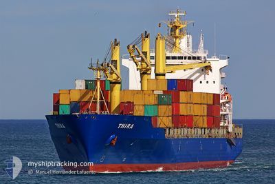
Container Ship
Current Trip
| Time Travelled | 1 day |
|---|---|
| Remaining Time | --- |
| Distance Travelled | 474.23 nm |
| Remaining Distance | --- |
| AVG Speed | 11.5 Noeuds |
| MAX Speed | 13.1 Noeuds |
| AVG Wind | 19.8 knots |
| MAX Wind | 24.8 knots |
| MIN Temp | 27°C / 80.6°F |
| MAX Temp | 28.7°C / 83.66°F |
| Tirant d eau | 9.7 m |
| Position reçue | 10 d depuis |
Current Position
| Longitude | --- |
|---|---|
| Latitude | --- |
| Etat | Under way using engine |
| Vitesse | 12.9 Noeuds |
| Parcours | 269.7° |
| Zone | Indian Ocean |
| Station | T-AIS |
| Position reçue | 10 d depuis |
Info
Information
The current position of MSC JANIS 3 is in Indian Ocean with coordinates -20.12940° / 57.29740° as reported on 2025-02-25 17:36 by AIS to our vessel tracker app. The vessel's current speed is 12.9 Noeuds and is heading at the port of TOAMASINA. The estimated time of arrival as calculated by MyShipTracking vessel tracking app is 2025-02-28 12:00 LT
The vessel MSC JANIS 3 (IMO: 9134490, MMSI: 636017116) is a Container Ship that was built in 1997 ( 28 Age ). It's sailing under the flag of [LR] Liberia.
In this page you can find informations about the vessels current position, last detected port calls, and current voyage information. If the vessels is not in coverage by AIS you will find the latest position.
The current position of MSC JANIS 3 is detected by our AIS receivers and we are not responsible for the reliability of the data. The last position was recorded while the vessel was in Coverage by the Ais receivers of our vessel tracking app.
The current draught of MSC JANIS 3 as reported by AIS is 9.7 meters
Weather
| Temperature | 28.5°C / 83.3°F |
|---|---|
| Wind Speed | 17 knots |
| Direction | 82° E |
| Pressure | 1012.6 hPa |
| Humidity | 77.1 % |
| Cloud Coverage | 100 % |
Featured Company
Last Port Calls
| Port | Arrival | Departure | Time In Port |
|---|---|---|---|
| 2025-03-05 02:35 | 2025-03-06 11:35 | 1 d | |
| 2025-02-28 05:32 | 2025-03-01 14:28 | 1 d | |
| 2025-02-24 18:45 | 2025-02-25 16:52 | 22 h | |
| 2025-02-23 17:31 | 2025-02-24 09:39 | 16 h | |
| 2025-02-11 10:55 | 2025-02-12 09:29 | 22 h | |
| 2025-02-08 13:29 | 2025-02-09 15:09 | 1 d | |
| 2025-02-03 15:28 | 2025-02-03 22:41 | 7 h | |
| 2025-02-01 07:33 | 2025-02-02 06:38 | 23 h | |
| 2025-01-28 02:54 | 2025-01-28 21:33 | 18 h | |
| 2025-01-25 10:17 | 2025-01-26 14:29 | 1 d |
Last Trips
| Origin | Departure | Destination | Arrival | Distance | |
|---|---|---|---|---|---|
| 2025-03-01 17:28 | 2025-03-05 06:35 | 437.52 nm | |||
| 2025-02-25 20:52 | 2025-02-28 08:32 | 552.02 nm | |||
| 2025-02-24 13:39 | 2025-02-24 22:45 | 5.02 nm | |||
| 2025-02-12 17:29 | 2025-02-23 21:31 | 3428.27 nm | |||
| 2025-02-09 22:09 | 2025-02-11 18:55 | 361.43 nm | |||
| 2025-02-04 06:41 | 2025-02-08 20:29 | 449.23 nm | |||
| 2025-02-02 13:38 | 2025-02-03 23:28 | 362.58 nm | |||
| 2025-01-29 05:33 | 2025-02-01 14:33 | 417.70 nm | |||
| 2025-01-26 21:29 | 2025-01-28 10:54 | 367.74 nm | |||
| 2025-01-22 03:21 | 2025-01-25 17:17 | 407.76 nm |
Events
| Heure | Evenement | Détails | Position/ Destination | Info |
|---|---|---|---|---|
| 2025-03-06 11:35 | Démarrage | 0.94 nm, North East of REUNION |
-20.91542 / 55.31206
MGTMM
|
Vitesse: 8.3 kn Parcours: 323° |
| 2025-03-06 11:35 | PORT DE DEPART |
|
-20.91542 / 55.31206
MGTMM
|
Vitesse: 2.3 kn Parcours: 339° |
| 2025-03-05 02:35 | Arret |
-20.93137 / 55.31838
[RE] REUNION
|
Vitesse: Parcours: 264° |
|
| 2025-03-05 02:35 | Port d'arrivée |
|
-20.93137 / 55.31838
[RE] REUNION
|
Vitesse: 1.1 kn Parcours: 259° |
| 2025-03-04 22:54 | Démarrage | 12.51 nm, North West of REUNION |
-20.76725 / 55.15518
MGTMM
|
Vitesse: 3.2 kn Parcours: 16° |
| 2025-03-04 16:03 | Arret | 16.09 nm, North of REUNION |
-20.67200 / 55.20610
MGTMM
|
Vitesse: 0.2 kn Parcours: 39° |
| 2025-03-04 13:51 | Démarrage | 19 nm, North West of REUNION |
-20.80220 / 54.98847
MGTMM
|
Vitesse: 3.8 kn Parcours: 71° |
| 2025-03-03 13:28 | Arret | 16.39 nm, North of REUNION |
-20.65860 / 55.23658
MGTMM
|
Vitesse: 0.3 kn Parcours: 103° |
| 2025-03-03 10:44 | Démarrage | 13.79 nm, North of REUNION |
-20.70762 / 55.22168
MGTMM
|
Vitesse: 3.7 kn Parcours: 316° |
| 2025-03-03 08:02 | Arret | 14.8 nm, North of REUNION |
-20.68947 / 55.22300
MGTMM
|
Vitesse: 0.3 kn Parcours: 16° |