
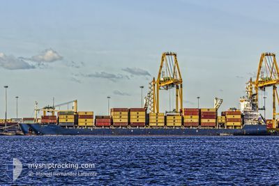
MSC ISHYKA
Container Ship

Current Trip
ZAZBA (ARMED GUARDS)
| Time Travelled | 2 days |
|---|---|
| Remaining Time | --- |
| Distance Travelled | 587.12 nm |
| Remaining Distance | --- |
| AVG Speed | 11.9 Noeuds |
| MAX Speed | 15.9 Noeuds |
| AVG Wind | 9.4 knots |
| MAX Wind | 16 knots |
| MIN Temp | 17.8°C / 64.04°F |
| MAX Temp | 25.9°C / 78.62°F |
| Tirant d eau | 9.3 m |
| Position reçue | 5 d depuis |
Current Position
| Longitude | --- |
|---|---|
| Latitude | --- |
| Etat | Under way using engine |
| Vitesse | 14.6 Noeuds |
| Parcours | 209.4° |
| Zone | Indian Ocean |
| Station | T-AIS |
| Position reçue | 5 d depuis |
Information
The current position of MSC ISHYKA is in Indian Ocean with coordinates -30.16236° / 31.03195° as reported on 2025-03-23 14:03 by AIS to our vessel tracker app. The vessel's current speed is 14.6 Noeuds
The vessel MSC ISHYKA (IMO: 9154206, MMSI: 636016457) is a Container Ship that was built in 1997 ( 28 Age ). It's sailing under the flag of [LR] Liberia.
In this page you can find informations about the vessels current position, last detected port calls, and current voyage information. If the vessels is not in coverage by AIS you will find the latest position.
The current position of MSC ISHYKA is detected by our AIS receivers and we are not responsible for the reliability of the data. The last position was recorded while the vessel was in Coverage by the Ais receivers of our vessel tracking app.
The current draught of MSC ISHYKA as reported by AIS is 9.3 meters
Weather
| Temperature | 25.8°C / 78.44°F |
|---|---|
| Wind Speed | 16 knots |
| Direction | 95° E |
| Pressure | 1018.2 hPa |
| Humidity | 77.5 % |
| Cloud Coverage | 10 % |
Featured Company
Last Port Calls
| Port | Arrival | Departure | Time In Port |
|---|---|---|---|
| 2025-03-24 14:14 | 2025-03-26 15:20 | 2 d | |
| 2025-03-15 19:45 | 2025-03-19 08:24 | 3 d | |
| 2025-03-11 02:03 | 2025-03-11 15:05 | 13 h | |
| 2025-03-07 03:28 | 2025-03-08 08:52 | 1 d | |
| 2025-02-26 14:49 | 2025-02-28 00:33 | 1 d | |
| 2025-02-24 07:24 | 2025-02-25 08:36 | 1 d | |
| 2025-02-14 02:50 | 2025-02-15 18:44 | 1 d | |
| 2025-02-07 09:08 | 2025-02-08 20:28 | 1 d | |
| 2025-02-05 02:30 | 2025-02-05 17:42 | 15 h | |
| 2025-01-27 04:13 | 2025-01-29 01:33 | 1 d |
Last Trips
| Origin | Departure | Destination | Arrival | Distance | |
|---|---|---|---|---|---|
| 2025-03-19 10:24 | 2025-03-24 16:14 | 1053.42 nm | |||
| 2025-03-11 19:05 | 2025-03-15 21:45 | 1501.45 nm | |||
| 2025-03-08 11:52 | 2025-03-11 06:03 | 393.93 nm | |||
| 2025-02-28 06:03 | 2025-03-07 06:28 | 2356.03 nm | |||
| 2025-02-25 14:06 | 2025-02-26 20:19 | 164.12 nm | |||
| 2025-02-15 21:44 | 2025-02-24 12:54 | 2402.78 nm | |||
| 2025-02-09 00:28 | 2025-02-14 05:50 | 478.90 nm | |||
| 2025-02-05 21:42 | 2025-02-07 13:08 | 134.85 nm | |||
| 2025-01-29 07:03 | 2025-02-05 06:30 | 2214.79 nm | |||
| 2025-01-18 16:49 | 2025-01-27 09:43 | 2366.47 nm |
Events
| Heure | Evenement | Détails | Position/ Destination | Info |
|---|---|---|---|---|
| 2025-03-26 15:20 | PORT DE DEPART |
|
-33.82697 / 25.68899
ZAZBA (ARMED GUARDS)
|
Vitesse: 6.8 kn Parcours: 191° |
| 2025-03-26 15:09 | Démarrage |
-33.80738 / 25.69226
[ZA] COEGA
|
Vitesse: 4.5 kn Parcours: 182° |
|
| 2025-03-24 14:45 | Arret |
-33.80012 / 25.68382
[ZA] COEGA
|
Vitesse: 0.2 kn Parcours: 151° |
|
| 2025-03-24 14:14 | Port d'arrivée |
|
-33.81305 / 25.69202
[ZA] COEGA
|
Vitesse: 6.7 kn Parcours: 359° |
| 2025-03-23 14:08 | Etat Changé | Default Under way using engine |
-30.17894 / 31.02137
ZAZBA (ARMED GUARDS)
|
Vitesse: 14.6 kn Parcours: 209.4° |
| 2025-03-23 14:03 | Hors de la zone couverte |
-30.16236 / 31.03195
Indian Ocean
ZAZBA (ARMED GUARDS)
|
Vitesse: 14.6 kn Parcours: 209.4° |
|
| 2025-03-23 12:16 | Démarrage | 9.59 nm, North East of DURBAN |
-29.75186 / 31.13817
ZAZBA (ARMED GUARDS)
|
Vitesse: 3.3 kn Parcours: 141° |
| 2025-03-23 12:10 | Etat Changé | Under way using engine At anchor |
-29.75292 / 31.13600
ZAZBA (ARMED GUARDS)
|
Vitesse: 0.1 kn Parcours: 48° |
| 2025-03-23 11:52 | Changement de destination | ZAZBA (ARMED GUARDS) ZADUR (ARMED GUARDS) |
-29.75313 / 31.13551
ZAZBA (ARMED GUARDS)
|
Vitesse: 0.1 kn Parcours: 72° |
| 2025-03-23 11:52 | Changement d'ETA | 2025/03/24 15:00 2025/03/22 12:30 |
-29.75313 / 31.13551
ZAZBA (ARMED GUARDS)
|
Vitesse: 0.1 kn Parcours: 72° |