

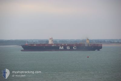
MSC CHLOE
Cargo D

Current Trip
| Time Travelled | 8 days |
|---|---|
| Remaining Time | --- |
| Distance Travelled | 3838.93 nm |
| Remaining Distance | --- |
| AVG Speed | 18.9 Noeuds |
| MAX Speed | 21.3 Noeuds |
| AVG Wind | 13.7 knots |
| MAX Wind | 21 knots |
| MIN Temp | 13.9°C / 57.02°F |
| MAX Temp | 27.1°C / 80.78°F |
| Tirant d eau | 12.9 m |
| Position reçue | 20 h, 44 m depuis |
Current Position
| Longitude | --- |
|---|---|
| Latitude | --- |
| Etat | Under way using engine |
| Vitesse | 19.1 Noeuds |
| Parcours | 56.2° |
| Zone | North Atlantic Ocean |
| Station | T-AIS |
| Position reçue | 20 h, 44 m depuis |
Information
The current position of MSC CHLOE is in North Atlantic Ocean with coordinates 36.89590° / -23.73704° as reported on 2025-03-04 23:30 by AIS to our vessel tracker app. The vessel's current speed is 19.1 Noeuds and is heading at the port of THAMES. The estimated time of arrival as calculated by MyShipTracking vessel tracking app is 2025-03-08 18:00 LT
The vessel MSC CHLOE (IMO: 9720483, MMSI: 255805855) is a Cargo D It's sailing under the flag of [PT] Portugal.
In this page you can find informations about the vessels current position, last detected port calls, and current voyage information. If the vessels is not in coverage by AIS you will find the latest position.
The current position of MSC CHLOE is detected by our AIS receivers and we are not responsible for the reliability of the data. The last position was recorded while the vessel was in Coverage by the Ais receivers of our vessel tracking app.
The current draught of MSC CHLOE as reported by AIS is 12.9 meters
Weather
| Temperature | 13.4°C / 56.12°F |
|---|---|
| Wind Speed | 7 knots |
| Direction | 21° NNE |
| Pressure | 1014 hPa |
| Humidity | 68.7 % |
| Cloud Coverage | 53 % |


Featured Company
Last Port Calls
| Port | Arrival | Departure | Time In Port |
|---|---|---|---|
| 2025-02-21 09:19 | 2025-02-25 08:47 | 3 d | |
| 2025-02-17 20:13 | 2025-02-18 22:38 | 1 d | |
| 2025-02-13 20:38 | 2025-02-14 11:30 | 14 h | |
| 2025-02-08 05:55 | 2025-02-09 15:57 | 1 d | |
| 2025-02-06 02:03 | 2025-02-07 06:46 | 1 d | |
| 2025-02-04 13:26 | 2025-02-05 11:31 | 22 h | |
| 2025-01-31 15:54 | 2025-02-01 15:37 | 23 h | |
| 2025-01-26 00:02 | 2025-01-27 18:33 | 1 d | |
| 2025-01-23 08:43 | 2025-01-25 10:46 | 2 d | |
| 2025-01-21 18:17 | 2025-01-22 13:22 | 19 h |
Most Visited Ports (Last year)
| Port | Arrivals | |
|---|---|---|
| 8 | ||
| 7 | ||
| 5 | ||
| 5 | ||
| 5 | ||
| 4 |
Last Trips
| Origin | Departure | Destination | Arrival | Distance | |
|---|---|---|---|---|---|
| 2025-02-18 17:38 | 2025-02-21 04:19 | 129.84 nm | |||
| 2025-02-14 06:30 | 2025-02-17 15:13 | 1374.42 nm | |||
| 2025-02-09 12:57 | 2025-02-13 15:38 | 1372.89 nm | |||
| 2025-02-07 03:46 | 2025-02-08 02:55 | 289.95 nm | |||
| 2025-02-05 08:31 | 2025-02-05 23:03 | 243.00 nm | |||
| 2025-02-01 10:37 | 2025-02-04 10:26 | 1339.78 nm | |||
| 2025-01-27 13:33 | 2025-01-31 10:54 | 1378.87 nm | |||
| 2025-01-25 05:46 | 2025-01-25 19:02 | 37.62 nm | |||
| 2025-01-22 08:22 | 2025-01-23 03:43 | 298.46 nm | |||
| 2025-01-12 02:56 | 2025-01-21 13:17 | 4194.25 nm |
Events
| Heure | Evenement | Détails | Position/ Destination | Info |
|---|---|---|---|---|
| 2025-03-04 23:51 | Etat Changé | Default Under way using engine |
36.95850 / -23.61734
GBLGP
|
Vitesse: 19.1 kn Parcours: 56.2° |
| 2025-03-04 23:30 | Hors de la zone couverte |
36.89590 / -23.73704
North Atlantic Ocean
GBLGP
|
Vitesse: 19.1 kn Parcours: 56.2° |
|
| 2025-03-04 17:57 | Tirant d'eau modifié | 12.9 14.6 |
35.96596 / -25.59403
GBLGP
|
Vitesse: 19.2 kn Parcours: 58.6° |
| 2025-03-04 17:57 | Changement de destination | GBLGP LAST UPDATE TIME |
35.96596 / -25.59403
GBLGP
|
Vitesse: 19.2 kn Parcours: 58.6° |
| 2025-03-04 17:57 | Changement d'ETA | 2025/03/08 18:00 2025/02/20 16:21 |
35.96596 / -25.59403
GBLGP
|
Vitesse: 19.2 kn Parcours: 58.6° |
| 2025-03-04 17:55 | Detecté en mer | Portuguese (Azores) part of the North Atlantic Ocean |
35.96026 / -25.60522
North Atlantic Ocean
|
Vitesse: 19.2 kn Parcours: 57.2° |
| 2025-03-04 17:55 | Etat Changé | Under way using engine Default |
35.95971 / -25.60633
LAST UPDATE TIME
|
Vitesse: 19.4 kn Parcours: 58° |
| 2025-03-04 17:36 | Dans la zone couverte |
35.96026 / -25.60522
North Atlantic Ocean
|
Vitesse: 19.2 kn Parcours: 57.2° |
|
| 2025-03-03 08:59 | Etat Changé | Default Under way using engine |
30.60214 / -36.42798
LAST UPDATE TIME
|
Vitesse: 19.2 kn Parcours: 57.1° |
| 2025-03-03 08:47 | Hors de la zone couverte |
30.56906 / -36.48892
North Atlantic Ocean
|
Vitesse: 19.2 kn Parcours: 57.1° |