
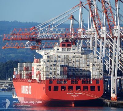
MONTE TAMARO
Container Ship
Current Trip
BRSSZ > BRRIO
| Time Travelled | 2 days |
|---|---|
| Remaining Time | --- |
| Distance Travelled | 1047.72 nm |
| Remaining Distance | --- |
| AVG Speed | 18.8 Noeuds |
| MAX Speed | 20.3 Noeuds |
| AVG Wind | 12.1 knots |
| MAX Wind | 18 knots |
| MIN Temp | 23.7°C / 74.66°F |
| MAX Temp | 36.1°C / 96.98°F |
| Tirant d eau | 12.8 m |
| Position reçue | 4 d depuis |
Current Position
| Longitude | --- |
|---|---|
| Latitude | --- |
| Etat | Under way using engine |
| Vitesse | 8.1 Noeuds |
| Parcours | 171° |
| Zone | South Atlantic Ocean |
| Station | T-AIS |
| Position reçue | 4 d depuis |
Info
Information
The current position of MONTE TAMARO is in South Atlantic Ocean with coordinates -23.97868° / -46.28925° as reported on 2025-02-13 17:25 by AIS to our vessel tracker app. The vessel's current speed is 8.1 Noeuds
The vessel MONTE TAMARO (IMO: 9357949, MMSI: 563052100) is a Container Ship that was built in 2007 ( 18 Age ). It's sailing under the flag of [SG] Singapore.
In this page you can find informations about the vessels current position, last detected port calls, and current voyage information. If the vessels is not in coverage by AIS you will find the latest position.
The current position of MONTE TAMARO is detected by our AIS receivers and we are not responsible for the reliability of the data. The last position was recorded while the vessel was in Coverage by the Ais receivers of our vessel tracking app.
The current draught of MONTE TAMARO as reported by AIS is 12.8 meters
Weather
| Temperature | 27.6°C / 81.68°F |
|---|---|
| Wind Speed | 14 knots |
| Direction | 164° SSE |
| Pressure | 1012.1 hPa |
| Humidity | 73.5 % |
| Cloud Coverage | 29 % |
Featured Company
Last Port Calls
| Port | Arrival | Departure | Time In Port |
|---|---|---|---|
| 2025-02-15 04:50 | 2025-02-15 05:02 | 12 m | |
| 2025-02-12 13:21 | 2025-02-13 14:48 | 1 d | |
| 2025-02-09 08:57 | 2025-02-10 06:55 | 21 h | |
| 2025-02-06 19:26 | 2025-02-07 11:29 | 16 h | |
| 2025-01-21 16:02 | 2025-01-26 10:10 | 4 d | |
| 2025-01-18 11:22 | 2025-01-19 06:30 | 19 h | |
| 2025-01-11 09:24 | 2025-01-12 10:29 | 1 d | |
| 2025-01-02 20:06 | 2025-01-03 06:28 | 10 h | |
| 2024-12-28 22:28 | 2024-12-29 15:01 | 16 h | |
| 2024-12-20 14:38 | 2024-12-21 23:25 | 1 d |
Most Visited Ports (Last year)
| Port | Arrivals | |
|---|---|---|
| 15 | ||
| 9 | ||
| 7 | ||
| 7 | ||
| 7 | ||
| 6 |
Last Trips
| Origin | Departure | Destination | Arrival | Distance | |
|---|---|---|---|---|---|
| 2025-02-13 14:48 | 2025-02-15 04:50 | 258.86 nm | |||
| 2025-02-10 06:55 | 2025-02-12 13:21 | 228.17 nm | |||
| 2025-02-07 11:29 | 2025-02-09 08:57 | 232.54 nm | |||
| 2025-01-26 10:10 | 2025-02-06 19:26 | 4948.48 nm | |||
| 2025-01-19 06:30 | 2025-01-21 16:02 | 650.05 nm | |||
| 2025-01-12 10:29 | 2025-01-18 11:22 | 298.80 nm | |||
| 2025-01-03 06:28 | 2025-01-11 09:24 | 3649.23 nm | |||
| 2024-12-29 15:01 | 2025-01-02 20:06 | 1750.90 nm | |||
| 2024-12-21 23:25 | 2024-12-28 22:28 | 210.66 nm | |||
| 2024-12-18 01:33 | 2024-12-20 14:38 | 864.34 nm |
Events
| Heure | Evenement | Détails | Position/ Destination | Info |
|---|---|---|---|---|
| 2025-02-15 16:14 | Démarrage | 2.4 nm, North West of RIO DE JANEIRO |
-22.87701 / -43.19690
BRSSZ > BRRIO
|
Vitesse: 6.2 kn Parcours: 126° |
| 2025-02-15 08:22 | Arret | 2.78 nm, North West of RIO DE JANEIRO |
-22.87471 / -43.20367
BRSSZ > BRRIO
|
Vitesse: 0.3 kn Parcours: 219° |
| 2025-02-15 08:02 | PORT DE DEPART |
|
-22.87849 / -43.19533
BRSSZ > BRRIO
|
Vitesse: 6.7 kn Parcours: 291° |
| 2025-02-15 07:50 | Port d'arrivée |
|
-22.88908 / -43.17796
[BR] RIO DE JANEIRO
|
Vitesse: 7.3 kn Parcours: 267° |
| 2025-02-15 06:01 | Démarrage | 12.6 nm, South of RIO DE JANEIRO |
-23.09675 / -43.24967
BRSSZ > BRRIO
|
Vitesse: 7.1 kn Parcours: 52° |
| 2025-02-15 04:08 | Arret | 13.25 nm, South West of RIO DE JANEIRO |
-23.10328 / -43.26271
BRSSZ > BRRIO
|
Vitesse: 0.1 kn Parcours: 219° |
| 2025-02-15 01:52 | Démarrage |
-23.33589 / -43.50638
BRSSZ > BRRIO
|
Vitesse: 10.5 kn Parcours: 41° |
|
| 2025-02-14 21:56 | Arret |
-23.34468 / -43.53572
BRSSZ > BRRIO
|
Vitesse: 0.3 kn Parcours: 168° |
|
| 2025-02-14 20:18 | Démarrage | 19.02 nm, South East of SEPETIBA |
-23.25132 / -43.51486
BRSSZ > BRRIO
|
Vitesse: 3.1 kn Parcours: 78° |
| 2025-02-14 17:24 | Arret | 18.12 nm, South East of SEPETIBA |
-23.24100 / -43.52778
BRSSZ > BRRIO
|
Vitesse: 0.2 kn Parcours: 167° |