
MIRELA
Cargo
Current Trip
| Time Travelled | 1 day |
|---|---|
| Remaining Time | 1 day |
| Distance Travelled | 520.87 nm |
| Remaining Distance | 487.69 nm |
| AVG Speed | 9.9 Noeuds |
| MAX Speed | 14.5 Noeuds |
| AVG Wind | 25.5 knots |
| MAX Wind | 35 knots |
| MIN Temp | 6.3°C / 43.34°F |
| MAX Temp | 12°C / 53.6°F |
| Tirant d eau | 7.2 m |
| Position reçue | 1 m depuis |
Current Position
| Longitude | --- |
|---|---|
| Latitude | --- |
| Etat | Under way using engine |
| Vitesse | 13.9 Noeuds |
| Parcours | 86.9° |
| Zone | Skaggerak |
| Station | T-AIS |
| Position reçue | 1 m depuis |
Info
Information
The current position of MIRELA is in Skaggerak with coordinates 57.80031° / 10.19168° as reported on 2024-11-29 09:43 by AIS to our vessel tracker app. The vessel's current speed is 13.9 Noeuds and is heading at the port of KLAIPEDA. The estimated time of arrival as calculated by MyShipTracking vessel tracking app is 2024-11-30 19:51 LT
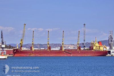
The vessel MIRELA (IMO: 9730218, MMSI: 212954000) is a Cargo It's sailing under the flag of [CY] Cyprus.
In this page you can find informations about the vessels current position, last detected port calls, and current voyage information. If the vessels is not in coverage by AIS you will find the latest position.
The current position of MIRELA is detected by our AIS receivers and we are not responsible for the reliability of the data. The last position was recorded while the vessel was in Coverage by the Ais receivers of our vessel tracking app.
The current draught of MIRELA as reported by AIS is 7.2 meters
Weather
| Temperature | 6.3°C / 43.34°F |
|---|---|
| Wind Speed | 18 knots |
| Direction | 217° SW |
| Pressure | 1027.3 hPa |
| Humidity | 87.2 % |
| Cloud Coverage | 100 % |
Featured Company
Last Port Calls
| Port | Arrival | Departure | Time In Port |
|---|---|---|---|
| 2024-11-25 19:14 | 2024-11-27 10:20 | 1 d | |
| 2024-11-19 15:26 | 2024-11-22 11:22 | 2 d | |
| 2024-11-11 21:51 | 2024-11-15 02:56 | 3 d | |
| 2024-11-07 19:24 | 2024-11-11 12:36 | 3 d | |
| 2024-11-05 03:46 | 2024-11-05 22:20 | 18 h | |
| 2024-09-09 06:37 | 2024-09-14 15:40 | 5 d | |
| 2024-09-04 05:04 | 2024-09-08 14:25 | 4 d | |
| 2024-09-01 22:13 |
Last Trips
| Origin | Departure | Destination | Arrival | Distance | |
|---|---|---|---|---|---|
| 2024-11-22 12:22 | 2024-11-25 20:14 | 902.01 nm | |||
| 2024-11-15 03:56 | 2024-11-19 16:26 | 959.02 nm | |||
| 2024-11-11 13:36 | 2024-11-11 22:51 | 113.43 nm | |||
| 2024-11-05 23:20 | 2024-11-07 20:24 | 502.30 nm | |||
| 2024-09-15 00:40 | 2024-11-05 04:46 | 9361.01 nm | |||
| 2024-09-08 23:25 | 2024-09-09 15:37 | 192.83 nm | |||
| 2024-09-02 06:13 | 2024-09-04 14:04 | 666.56 nm |
Events
| Heure | Evenement | Détails | Position/ Destination | Info |
|---|---|---|---|---|
| 2024-11-29 06:57 | Changement d'ETA | 2024/11/30 21:00 2024/11/30 19:00 |
57.61023 / 9.05372
LT KLJ
|
Vitesse: 13.9 kn Parcours: 61.4° |
| 2024-11-29 04:40 | Changement de zone | Danish part of the Skaggerak Danish part of the North Sea |
57.33259 / 8.23377
Skaggerak
LT KLJ
|
Vitesse: 14.1 kn Parcours: 32.9° |
| 2024-11-28 20:26 | Etat Changé | Under way using engine Default |
55.87483 / 6.30003
LT KLJ
|
Vitesse: 12.9 kn Parcours: 27° |
| 2024-11-28 20:13 | Etat Changé | Default Under way using engine |
55.83303 / 6.26113
LT KLJ
|
Vitesse: 12.9 kn Parcours: 26.8° |
| 2024-11-28 20:01 | Etat Changé | Under way using engine Default |
55.79566 / 6.22809
LT KLJ
|
Vitesse: 13 kn Parcours: 27° |
| 2024-11-28 19:26 | Etat Changé | Default Under way using engine |
55.68401 / 6.13175
LT KLJ
|
Vitesse: 12.8 kn Parcours: 27.1° |
| 2024-11-28 19:19 | Detecté en mer | Danish part of the North Sea |
55.66074 / 6.11090
North Sea
LT KLJ
|
Vitesse: 12.8 kn Parcours: 27.1° |
| 2024-11-28 19:19 | Etat Changé | Under way using engine Default |
55.66074 / 6.11090
LT KLJ
|
Vitesse: 13 kn Parcours: 27° |
| 2024-11-28 19:19 | Dans la zone couverte |
55.66074 / 6.11090
North Sea
LT KLJ
|
Vitesse: 12.8 kn Parcours: 27.1° |
|
| 2024-11-28 18:02 | Hors de la zone couverte |
55.41895 / 5.88809
North Sea
LT KLJ
|
Vitesse: 12.8 kn Parcours: 29.5° |