
MICHIGAN
Container Ship
Current Trip
| Time Travelled | 6 h, 47 mins |
|---|---|
| Remaining Time | --- |
| Distance Travelled | --- |
| Remaining Distance | --- |
| AVG Speed | --- |
| MAX Speed | --- |
| AVG Wind | --- |
| MAX Wind | --- |
| MIN Temp | --- |
| MAX Temp | --- |
| Tirant d eau | 9.2 m |
| Position reçue | 2 d depuis |
Current Position
| Longitude | --- |
|---|---|
| Latitude | --- |
| Etat | Under way using engine |
| Vitesse | 12.4 Noeuds |
| Parcours | 169.4° |
| Zone | Adriatic Sea |
| Station | T-AIS |
| Position reçue | 2 d depuis |
Info
Information
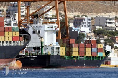
The current position of MICHIGAN is in Adriatic Sea with coordinates 44.62053° / 14.12260° as reported on 2026-01-05 22:16 by AIS to our vessel tracker app. The vessel's current speed is 12.4 Noeuds
The vessel MICHIGAN (IMO: 9437139, MMSI: 215020000) is a Container Ship that was built in 2008 ( 18 Age ). It's sailing under the flag of [MT] Malta.
In this page you can find informations about the vessels current position, last detected port calls, and current voyage information. If the vessels is not in coverage by AIS you will find the latest position.
The current position of MICHIGAN is detected by our AIS receivers and we are not responsible for the reliability of the data. The last position was recorded while the vessel was in Coverage by the Ais receivers of our vessel tracking app.
The current draught of MICHIGAN as reported by AIS is 9.2 meters
Weather
| Temperature | 6.2°C / 43.16°F |
|---|---|
| Wind Speed | 19 knots |
| Direction | 329° NNW |
| Pressure | 1012.4 hPa |
| Humidity | 51.3 % |
| Cloud Coverage | 6 % |
Featured Company
Last Port Calls
| Port | Arrival | Departure | Time In Port |
|---|---|---|---|
| 2026-01-08 07:30 | |||
| 2025-12-31 00:41 | 2025-12-31 16:38 | 15 h | |
| 2025-12-28 14:17 | 2025-12-29 23:17 | 1 d | |
| 2025-12-23 08:10 | 2025-12-24 00:29 | 16 h | |
| 2025-12-21 21:54 | 2025-12-22 16:56 | 19 h | |
| 2025-12-18 07:20 | 2025-12-18 18:11 | 10 h | |
| 2025-12-16 03:02 | 2025-12-16 15:42 | 12 h | |
| 2025-12-13 10:42 | 2025-12-14 17:25 | 1 d | |
| 2025-12-09 15:01 | 2025-12-10 03:01 | 12 h | |
| 2025-12-06 14:07 | 2025-12-07 00:24 | 10 h |
Most Visited Ports (Last year)
| Port | Arrivals | |
|---|---|---|
| 24 | ||
| 23 | ||
| 11 | ||
| 11 | ||
| 11 | ||
| 10 |
Last Trips
| Origin | Departure | Destination | Arrival | Distance | |
|---|---|---|---|---|---|
| 2025-12-29 23:17 | 2025-12-31 00:41 | 207.14 nm | |||
| 2025-12-24 00:29 | 2025-12-28 14:17 | 1095.73 nm | |||
| 2025-12-22 16:56 | 2025-12-23 08:10 | 91.01 nm | |||
| 2025-12-18 18:11 | 2025-12-21 21:54 | 617.94 nm | |||
| 2025-12-16 15:42 | 2025-12-18 07:20 | 531.60 nm | |||
| 2025-12-14 17:25 | 2025-12-16 03:02 | 202.53 nm | |||
| 2025-12-07 00:24 | 2025-12-09 15:01 | 715.99 nm | |||
| 2025-12-05 23:26 | 2025-12-06 14:07 | 184.84 nm | |||
| 2025-11-29 04:21 | 2025-12-04 08:49 | 769.88 nm | |||
| 2025-11-24 12:28 | 2025-11-27 16:33 | 151.62 nm |
Events
| Heure | Evenement | Détails | Position/ Destination | Info |
|---|---|---|---|---|
| 2026-01-08 06:30 | PORT DE DEPART |
|
43.03841 / 17.38051
HRRJK
|
Vitesse: Parcours: 84° |
| 2026-01-05 22:21 | Etat Changé | Default Under way using engine |
44.60396 / 14.12687
HRRJK
|
Vitesse: 12.4 kn Parcours: 169.4° |
| 2026-01-05 22:16 | Etat Changé | Under way using engine Default |
44.62053 / 14.12260
HRRJK
|
Vitesse: 12.4 kn Parcours: 174° |
| 2026-01-05 22:16 | Hors de la zone couverte |
44.62053 / 14.12260
Adriatic Sea
|
Vitesse: 12.4 kn Parcours: 169.4° |
|
| 2026-01-05 22:01 | Dans la zone couverte |
44.62053 / 14.12260
Adriatic Sea
|
Vitesse: 12.4 kn Parcours: 169.4° |
|
| 2026-01-05 18:41 | Démarrage | 1.71 nm, South East of RIJEKA |
45.31362 / 14.45786
HRRJK
|
Vitesse: 4.9 kn Parcours: 205° |
| 2026-01-03 11:25 | Arret | 1.48 nm, East of RIJEKA |
45.31930 / 14.45559
HRRJK
|
Vitesse: 0.1 kn Parcours: 103° |
| 2026-01-03 07:29 | Etat Changé | Default Under way using engine |
44.78037 / 14.15199
HRRJK
|
Vitesse: 8.8 kn Parcours: 16.2° |
| 2026-01-03 07:21 | Etat Changé | Under way using engine Default |
44.76228 / 14.14453
HRRJK
|
Vitesse: 8.8 kn Parcours: 17° |
| 2026-01-03 07:21 | Hors de la zone couverte |
44.76228 / 14.14453
Adriatic Sea
HRRJK
|
Vitesse: 8.8 kn Parcours: 16.2° |