
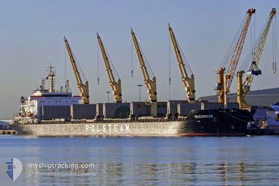
MAZOWSZE
Bulk Carrier
Current Trip
| Time Travelled | 16 days |
|---|---|
| Remaining Time | 2 days |
| Distance Travelled | 4753.68 nm |
| Remaining Distance | 724.32 nm |
| AVG Speed | 11.8 Noeuds |
| MAX Speed | 15.4 Noeuds |
| AVG Wind | 11.1 knots |
| MAX Wind | 23.3 knots |
| MIN Temp | 17.5°C / 63.5°F |
| MAX Temp | 27.8°C / 82.04°F |
| Tirant d eau | 10.7 m |
| Position reçue | 5 d depuis |
Current Position
| Longitude | -32.85206° |
|---|---|
| Latitude | 40.03077° |
| Etat | Under way using engine |
| Vitesse | 12 Noeuds |
| Parcours | 269.3° |
| Zone | North Atlantic Ocean |
| Station | T-AIS |
| Position reçue | 5 d depuis |
Info
Information
The current position of MAZOWSZE is in North Atlantic Ocean with coordinates 40.03077° / -32.85206° as reported on 2024-06-11 08:50 by AIS to our vessel tracker app. The vessel's current speed is 12 Noeuds and is heading at the port of WILMINGTON. The estimated time of arrival as calculated by MyShipTracking vessel tracking app is 2024-06-19 04:56 LT
The vessel MAZOWSZE (IMO: 9386914, MMSI: 311005700) is a Bulk Carrier that was built in 2009 ( 15 Age ). It's sailing under the flag of [BS] Bahamas.
In this page you can find informations about the vessels current position, last detected port calls, and current voyage information. If the vessels is not in coverage by AIS you will find the latest position.
The current position of MAZOWSZE is detected by our AIS receivers and we are not responsible for the reliability of the data. The last position was recorded while the vessel was in Coverage by the Ais receivers of our vessel tracking app.
The current draught of MAZOWSZE as reported by AIS is 10.7 meters
Weather
| Temperature | 21.9°C / 71.42°F |
|---|---|
| Wind Speed | 18 knots |
| Direction | 28° NNE |
| Pressure | 1020.4 hPa |
| Humidity | 68.4 % |
| Cloud Coverage | 18 % |
Featured Company
Most Visited Ports (Last year)
| Port | Arrivals | |
|---|---|---|
| 1 | ||
| 1 | ||
| 1 | ||
| 1 | ||
| 1 | ||
| 1 |
Events
| Heure | Evenement | Détails | Position/ Destination | Info |
|---|---|---|---|---|
| 2024-06-11 08:59 | Etat Changé | Default Under way using engine |
40.03072 / -32.89075
US ILM
|
Vitesse: 12 kn Parcours: 269.3° |
| 2024-06-11 08:50 | Hors de la zone couverte |
40.03077 / -32.85206
North Atlantic Ocean
US ILM
|
Vitesse: 12 kn Parcours: 269.3° |
|
| 2024-06-11 08:50 | Etat Changé | Under way using engine Default |
40.03077 / -32.85206
US ILM
|
Vitesse: 12 kn Parcours: 270° |
| 2024-06-11 08:50 | Dans la zone couverte |
40.03077 / -32.85206
North Atlantic Ocean
US ILM
|
Vitesse: 12 kn Parcours: 269.3° |
|
| 2024-06-11 07:53 | Etat Changé | Default Under way using engine |
40.02667 / -32.60667
US ILM
|
Vitesse: 12.3 kn Parcours: 273° |
| 2024-06-11 07:50 | Etat Changé | Under way using engine Default |
40.02707 / -32.59417
US ILM
|
Vitesse: 12.3 kn Parcours: 273° |
| 2024-06-11 07:50 | Hors de la zone couverte |
40.02707 / -32.59417
North Atlantic Ocean
US ILM
|
Vitesse: 12.3 kn Parcours: 273° |
|
| 2024-06-11 07:37 | Etat Changé | Default Under way using engine |
40.02482 / -32.53260
US ILM
|
Vitesse: 12.2 kn Parcours: 272° |
| 2024-06-11 07:30 | Etat Changé | Under way using engine Default |
40.02404 / -32.50438
US ILM
|
Vitesse: 12.1 kn Parcours: 270° |
| 2024-06-11 07:14 | Dans la zone couverte |
40.02404 / -32.50438
North Atlantic Ocean
US ILM
|
Vitesse: 12.2 kn Parcours: 271.1° |