
MAX SCHULTE
Cargo
Current Trip
| Time Travelled | 2 days |
|---|---|
| Remaining Time | 2 days |
| Distance Travelled | 397.78 nm |
| Remaining Distance | 707.17 nm |
| AVG Speed | 8.3 Noeuds |
| MAX Speed | 16.1 Noeuds |
| AVG Wind | 19 knots |
| MAX Wind | 44.5 knots |
| MIN Temp | 3.7°C / 38.66°F |
| MAX Temp | 16.2°C / 61.16°F |
| Tirant d eau | 8.3 m |
| Position reçue | Maintenant |
Current Position
| Longitude | --- |
|---|---|
| Latitude | --- |
| Etat | Under way using engine |
| Vitesse | 15.8 Noeuds |
| Parcours | 230.3° |
| Zone | Sea of Marmara |
| Station | T-AIS |
| Position reçue | Maintenant |
Info
Information
The current position of MAX SCHULTE is in Sea of Marmara with coordinates 40.30036° / 26.57367° as reported on 2026-01-08 22:31 by AIS to our vessel tracker app. The vessel's current speed is 15.8 Noeuds and is heading at the port of SUEZ CANAL. The estimated time of arrival as calculated by MyShipTracking vessel tracking app is 2026-01-11 01:46 LT
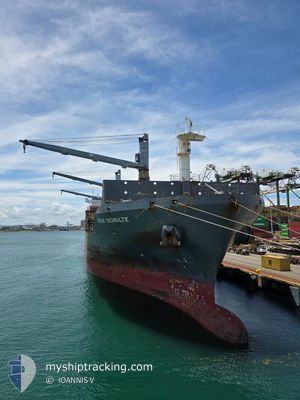
The vessel MAX SCHULTE (IMO: 9676711, MMSI: 565380000) is a Cargo It's sailing under the flag of [SG] Singapore.
In this page you can find informations about the vessels current position, last detected port calls, and current voyage information. If the vessels is not in coverage by AIS you will find the latest position.
The current position of MAX SCHULTE is detected by our AIS receivers and we are not responsible for the reliability of the data. The last position was recorded while the vessel was in Coverage by the Ais receivers of our vessel tracking app.
The current draught of MAX SCHULTE as reported by AIS is 8.3 meters
Weather
| Temperature | 8°C / 46.4°F |
|---|---|
| Wind Speed | 12 knots |
| Direction | 284° WNW |
| Pressure | 1006.4 hPa |
| Humidity | 54.6 % |
| Cloud Coverage | 72 % |
Featured Company
Last Port Calls
| Port | Arrival | Departure | Time In Port |
|---|---|---|---|
| 2026-01-04 17:33 | 2026-01-06 11:40 | 1 d | |
| 2025-12-29 00:48 | 2025-12-30 05:32 | 1 d | |
| 2025-12-25 06:08 | 2025-12-26 02:03 | 19 h | |
| 2025-12-21 17:22 | 2025-12-24 08:06 | 2 d | |
| 2025-12-15 03:05 | 2025-12-16 14:46 | 1 d | |
| 2025-12-12 04:11 | 2025-12-12 20:20 | 16 h | |
| 2025-12-08 08:25 | 2025-12-10 11:33 | 2 d | |
| 2025-11-30 20:08 | 2025-12-02 00:37 | 1 d | |
| 2025-11-27 15:51 | 2025-11-28 15:45 | 23 h | |
| 2025-11-24 16:17 | 2025-11-26 08:37 | 1 d |
Most Visited Ports (Last year)
| Port | Arrivals | |
|---|---|---|
| 14 | ||
| 13 | ||
| 12 | ||
| 6 | ||
| 4 | ||
| 3 |
Last Trips
| Origin | Departure | Destination | Arrival | Distance | |
|---|---|---|---|---|---|
| 2025-12-26 02:03 | 2026-01-04 17:33 | 1894.98 nm | |||
| 2025-12-26 02:03 | 2025-12-29 00:48 | 814.03 nm | |||
| 2025-12-24 08:06 | 2025-12-25 06:08 | 213.38 nm | |||
| 2025-12-12 20:20 | 2025-12-21 17:22 | 1857.79 nm | |||
| 2025-12-12 20:20 | 2025-12-15 03:05 | 808.08 nm | |||
| 2025-12-10 11:33 | 2025-12-12 04:11 | 235.65 nm | |||
| 2025-11-28 15:45 | 2025-12-08 08:25 | 1935.80 nm | |||
| 2025-11-28 15:45 | 2025-11-30 20:08 | 803.27 nm | |||
| 2025-11-26 08:37 | 2025-11-27 15:51 | 230.84 nm | |||
| 2025-11-22 23:09 | 2025-11-24 16:17 | 250.11 nm |
Events
| Heure | Evenement | Détails | Position/ Destination | Info |
|---|---|---|---|---|
| 2026-01-08 22:19 | Etat Changé | Under way using engine Default |
40.33554 / 26.62448
EGPSE
|
Vitesse: 16 kn Parcours: 213° |
| 2026-01-08 22:13 | Dans la zone couverte |
40.33308 / 26.62108
Sea of Marmara
EGPSE
|
Vitesse: 16.1 kn Parcours: 226.2° |
|
| 2026-01-08 19:49 | Etat Changé | Default Under way using engine |
40.61760 / 27.24586
EGPSE
|
Vitesse: 14.1 kn Parcours: 246.8° |
| 2026-01-08 19:43 | Etat Changé | Under way using engine Default |
40.62553 / 27.27066
EGPSE
|
Vitesse: 14 kn Parcours: 246° |
| 2026-01-08 19:43 | Hors de la zone couverte |
40.62553 / 27.27066
Sea of Marmara
EGPSE
|
Vitesse: 14.1 kn Parcours: 246.8° |
|
| 2026-01-08 19:36 | Dans la zone couverte |
40.62553 / 27.27066
Sea of Marmara
EGPSE
|
Vitesse: 14.1 kn Parcours: 246.8° |
|
| 2026-01-08 18:33 | Etat Changé | Default Under way using engine |
40.75137 / 27.58971
EGPSE
|
Vitesse: 14.3 kn Parcours: 252° |
| 2026-01-08 18:28 | Hors de la zone couverte |
40.75809 / 27.61269
Sea of Marmara
EGPSE
|
Vitesse: 14.3 kn Parcours: 252° |
|
| 2026-01-08 16:20 | Démarrage | 7.63 nm, South East of MARTAS |
40.85581 / 28.02697
EGPSE
|
Vitesse: 3.4 kn Parcours: 214° |
| 2026-01-08 14:01 | Arret | 6.18 nm, South East of EREGLI |
40.88950 / 28.03771
EGPSE
|
Vitesse: 0.2 kn Parcours: 344° |