
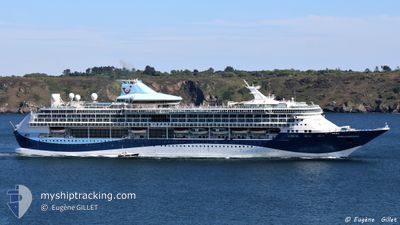
MARELLA DISCOVERY
Passengers Ship
Current Trip
| Time Travelled | 1 day |
|---|---|
| Remaining Time | 2 h, 58 mins |
| Distance Travelled | 478.89 nm |
| Remaining Distance | 48.41 nm |
| AVG Speed | 16 Noeuds |
| MAX Speed | 19.6 Noeuds |
| AVG Wind | 6.5 knots |
| MAX Wind | 13 knots |
| MIN Temp | 25.2°C / 77.36°F |
| MAX Temp | 27°C / 80.6°F |
| Tirant d eau | 8 m |
| Position reçue | 1 m depuis |
Current Position
| Longitude | --- |
|---|---|
| Latitude | --- |
| Etat | Under way using engine |
| Vitesse | 13.5 Noeuds |
| Parcours | 294° |
| Zone | Caribbean Sea |
| Station | T-AIS |
| Position reçue | 1 m depuis |
Info
Information
The current position of MARELLA DISCOVERY is in Caribbean Sea with coordinates 18.61856° / -65.39036° as reported on 2025-03-18 06:12 by AIS to our vessel tracker app. The vessel's current speed is 13.5 Noeuds and is heading at the port of SAN JUAN. The estimated time of arrival as calculated by MyShipTracking vessel tracking app is 2025-03-18 05:11 LT
The vessel MARELLA DISCOVERY (IMO: 9070632, MMSI: 249639000) is a Passengers Ship that was built in 1996 ( 29 Age ). It's sailing under the flag of [MT] Malta.
In this page you can find informations about the vessels current position, last detected port calls, and current voyage information. If the vessels is not in coverage by AIS you will find the latest position.
The current position of MARELLA DISCOVERY is detected by our AIS receivers and we are not responsible for the reliability of the data. The last position was recorded while the vessel was in Coverage by the Ais receivers of our vessel tracking app.
The current draught of MARELLA DISCOVERY as reported by AIS is 8 meters
Weather
| Temperature | 25.2°C / 77.36°F |
|---|---|
| Wind Speed | 8 knots |
| Direction | 52° NE |
| Pressure | 1013.9 hPa |
| Humidity | 70.4 % |
| Cloud Coverage | 5 % |
Featured Company
Last Port Calls
| Port | Arrival | Departure | Time In Port |
|---|---|---|---|
| 2025-03-16 06:40 | 2025-03-16 20:47 | 14 h | |
| 2025-03-15 07:27 | 2025-03-15 16:22 | 8 h | |
| 2025-03-14 07:27 | 2025-03-14 17:50 | 10 h | |
| 2025-03-13 07:48 | 2025-03-13 17:43 | 9 h | |
| 2025-03-12 06:58 | 2025-03-12 17:49 | 10 h | |
| 2025-03-11 07:18 | 2025-03-11 17:56 | 10 h | |
| 2025-03-09 06:45 | 2025-03-09 20:11 | 13 h | |
| 2025-03-08 07:15 | 2025-03-08 18:02 | 10 h | |
| 2025-03-07 07:12 | 2025-03-07 18:19 | 11 h | |
| 2025-03-04 08:27 | 2025-03-04 19:51 | 11 h |
Last Trips
| Origin | Departure | Destination | Arrival | Distance | |
|---|---|---|---|---|---|
| 2025-03-15 16:22 | 2025-03-16 06:40 | 223.01 nm | |||
| 2025-03-14 17:50 | 2025-03-15 07:27 | 166.95 nm | |||
| 2025-03-13 17:43 | 2025-03-14 07:27 | 154.72 nm | |||
| 2025-03-12 17:49 | 2025-03-13 07:48 | 127.15 nm | |||
| 2025-03-11 17:56 | 2025-03-12 06:58 | 138.33 nm | |||
| 2025-03-09 20:11 | 2025-03-11 07:18 | 324.00 nm | |||
| 2025-03-08 18:02 | 2025-03-09 06:45 | 109.93 nm | |||
| 2025-03-07 18:19 | 2025-03-08 07:15 | 135.70 nm | |||
| 2025-03-04 19:51 | 2025-03-07 07:12 | 621.92 nm | |||
| 2025-03-02 20:14 | 2025-03-04 08:27 | 559.96 nm |
Events
| Heure | Evenement | Détails | Position/ Destination | Info |
|---|---|---|---|---|
| 2025-03-18 02:53 | Etat Changé | Under way using engine Default |
18.04850 / -64.74215
PRSJU
|
Vitesse: 16.5 kn Parcours: 301° |
| 2025-03-18 02:52 | Etat Changé | Default Under way using engine |
18.04524 / -64.73626
PRSJU
|
Vitesse: 16.5 kn Parcours: 300.9° |
| 2025-03-18 02:36 | Etat Changé | Under way using engine Default |
18.01018 / -64.67235
PRSJU
|
Vitesse: 16.9 kn Parcours: 300° |
| 2025-03-18 02:36 | Etat Changé | Default Under way using engine |
18.00878 / -64.66972
PRSJU
|
Vitesse: 16 kn Parcours: 301° |
| 2025-03-18 02:29 | Changement de zone | Puerto Rican part of the Caribbean Sea Guadeloupe and Martinique part of the Caribbean Sea |
17.99171 / -64.63846
Caribbean Sea
PRSJU
|
Vitesse: 16 kn Parcours: 300° |
| 2025-03-18 02:29 | Etat Changé | Under way using engine Default |
17.99171 / -64.63846
PRSJU
|
Vitesse: 16.8 kn Parcours: 300° |
| 2025-03-18 02:16 | Dans la zone couverte |
17.99171 / -64.63846
Caribbean Sea
PRSJU
|
Vitesse: 16 kn Parcours: 300° |
|
| 2025-03-17 10:37 | Etat Changé | Default Under way using engine |
14.72073 / -61.62555
PRSJU
|
Vitesse: 16.7 kn Parcours: 328.9° |
| 2025-03-17 10:22 | Hors de la zone couverte |
14.66204 / -61.58487
Caribbean Sea
PRSJU
|
Vitesse: 16.7 kn Parcours: 328.9° |
|
| 2025-03-17 08:14 | Changement de zone | Guadeloupe and Martinique part of the Caribbean Sea Saint Lucia part of the Caribbean Sea |
14.23461 / -61.18716
Caribbean Sea
PRSJU
|
Vitesse: 17.3 kn Parcours: 282.3° |