
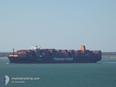
MANILA EXPRESS
Cargo A
Current Trip
| Time Travelled | 2 days |
|---|---|
| Remaining Time | --- |
| Distance Travelled | 1177.03 nm |
| Remaining Distance | --- |
| AVG Speed | 16.4 Noeuds |
| MAX Speed | 18.2 Noeuds |
| AVG Wind | 13 knots |
| MAX Wind | 23.4 knots |
| MIN Temp | 15.2°C / 59.36°F |
| MAX Temp | 20.9°C / 69.62°F |
| Tirant d eau | 14.3 m |
| Position reçue | Maintenant |
Current Position
| Longitude | -18.83216° |
|---|---|
| Latitude | 21.26945° |
| Etat | Under way using engine |
| Vitesse | 16.4 Noeuds |
| Parcours | 179.7° |
| Zone | North Atlantic Ocean |
| Station | T-AIS |
| Position reçue | Maintenant |
Info
Information
The current position of MANILA EXPRESS is in North Atlantic Ocean with coordinates 21.26945° / -18.83216° as reported on 2024-05-08 04:33 by AIS to our vessel tracker app. The vessel's current speed is 16.4 Noeuds and is heading at the port of SINGAPORE. The estimated time of arrival as calculated by MyShipTracking vessel tracking app is 2024-06-01 01:00 LT
The vessel MANILA EXPRESS (IMO: 9540120, MMSI: 218006290) is a Cargo A It's sailing under the flag of [DE] Germany.
In this page you can find informations about the vessels current position, last detected port calls, and current voyage information. If the vessels is not in coverage by AIS you will find the latest position.
The current position of MANILA EXPRESS is detected by our AIS receivers and we are not responsible for the reliability of the data. The last position was recorded while the vessel was in Coverage by the Ais receivers of our vessel tracking app.
The current draught of MANILA EXPRESS as reported by AIS is 14.3 meters
Weather
| Temperature | 20.4°C / 68.72°F |
|---|---|
| Wind Speed | 12 knots |
| Direction | 10° N |
| Pressure | 1010.3 hPa |
| Humidity | 90 % |
| Cloud Coverage | 78 % |
Featured Company
Last Port Calls
| Port | Arrival | Departure | Time In Port |
|---|---|---|---|
| 2024-05-04 16:57 | 2024-05-05 07:04 | 14 h | |
| 2024-04-28 21:20 | 2024-05-01 12:33 | 2 d | |
| 2024-04-25 01:56 | 2024-04-27 00:51 | 1 d | |
| 2024-04-18 23:34 | 2024-04-22 09:29 | 3 d | |
| 2024-04-12 17:20 | 2024-04-17 18:28 | 5 d | |
| 2024-03-12 07:31 | 2024-03-13 22:44 | 1 d | |
| 2024-03-01 11:32 | 2024-03-02 10:44 | 23 h |
Most Visited Ports (Last year)
| Port | Arrivals | |
|---|---|---|
| 5 | ||
| 5 | ||
| 3 | ||
| 3 | ||
| 3 | ||
| 3 |
Last Trips
| Origin | Departure | Destination | Arrival | Distance | |
|---|---|---|---|---|---|
| 2024-05-01 13:33 | 2024-05-04 18:57 | 1241.93 nm | |||
| 2024-04-27 02:51 | 2024-04-28 22:20 | 270.89 nm | |||
| 2024-04-22 11:29 | 2024-04-25 03:56 | 461.70 nm | |||
| 2024-04-17 20:28 | 2024-04-19 01:34 | 324.95 nm | |||
| 2024-03-14 06:44 | 2024-04-12 19:20 | 11973.60 nm | |||
| 2024-03-02 18:44 | 2024-03-12 15:31 | 1783.09 nm | |||
| 2024-02-23 20:45 | 2024-03-01 19:32 | 374.53 nm |
Events
| Heure | Evenement | Détails | Position/ Destination | Info |
|---|---|---|---|---|
| 2024-05-08 04:29 | Etat Changé | Under way using engine Default |
21.28685 / -18.83207
ESALG>SGSIN
|
Vitesse: 16.4 kn Parcours: 180° |
| 2024-05-08 04:18 | Etat Changé | Default Under way using engine |
21.33472 / -18.83223
ESALG>SGSIN
|
Vitesse: 16.5 kn Parcours: 180.2° |
| 2024-05-08 03:49 | Etat Changé | Under way using engine Default |
21.47036 / -18.83422
ESALG>SGSIN
|
Vitesse: 16.3 kn Parcours: 179° |
| 2024-05-08 03:46 | Etat Changé | Default Under way using engine |
21.48078 / -18.83446
ESALG>SGSIN
|
Vitesse: 16.2 kn Parcours: 180.2° |
| 2024-05-08 03:37 | Etat Changé | Under way using engine Default |
21.52490 / -18.83509
ESALG>SGSIN
|
Vitesse: 16.1 kn Parcours: 179° |
| 2024-05-08 03:35 | Etat Changé | Default Under way using engine |
21.53478 / -18.83523
ESALG>SGSIN
|
Vitesse: 16.2 kn Parcours: 180.6° |
| 2024-05-08 02:32 | Etat Changé | Under way using engine Default |
21.81796 / -18.83187
ESALG>SGSIN
|
Vitesse: 16.1 kn Parcours: 181° |
| 2024-05-08 01:54 | Etat Changé | Default Under way using engine |
21.98611 / -18.82033
ESALG>SGSIN
|
Vitesse: 16.3 kn Parcours: 197.3° |
| 2024-05-08 01:37 | Etat Changé | Under way using engine Default |
22.05907 / -18.79582
ESALG>SGSIN
|
Vitesse: 16 kn Parcours: 197° |
| 2024-05-08 01:37 | Dans la zone couverte |
22.05864 / -18.79597
North Atlantic Ocean
ESALG>SGSIN
|
Vitesse: 16.3 kn Parcours: 198.1° |