
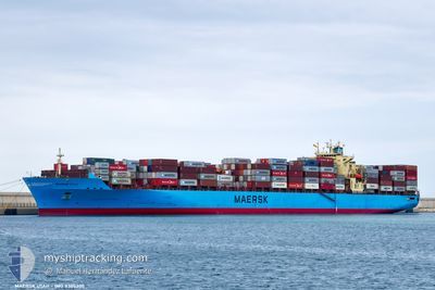
MAERSK UTAH
Container Ship
Current Trip
| Time Travelled | 2 days |
|---|---|
| Remaining Time | --- |
| Distance Travelled | 870.82 nm |
| Remaining Distance | --- |
| AVG Speed | 15.3 Noeuds |
| MAX Speed | 18.3 Noeuds |
| AVG Wind | 8.4 knots |
| MAX Wind | 17 knots |
| MIN Temp | 9.5°C / 49.1°F |
| MAX Temp | 14.6°C / 58.28°F |
| Tirant d eau | 13.2 m |
| Position reçue | 9 h, 22 m depuis |
Current Position
| Longitude | -6.29364° |
|---|---|
| Latitude | 48.29842° |
| Etat | Under way using engine |
| Vitesse | 16.2 Noeuds |
| Parcours | 206.2° |
| Zone | Celtic Sea |
| Station | T-AIS |
| Position reçue | 9 h, 22 m depuis |
Info
Information
The current position of MAERSK UTAH is in Celtic Sea with coordinates 48.29842° / -6.29364° as reported on 2024-05-24 23:02 by AIS to our vessel tracker app. The vessel's current speed is 16.2 Noeuds and is heading at the port of ASHDOD. The estimated time of arrival as calculated by MyShipTracking vessel tracking app is 2024-06-01 21:30 LT
The vessel MAERSK UTAH (IMO: 9305300, MMSI: 563757000) is a Container Ship that was built in 2006 ( 18 Age ). It's sailing under the flag of [SG] Singapore.
In this page you can find informations about the vessels current position, last detected port calls, and current voyage information. If the vessels is not in coverage by AIS you will find the latest position.
The current position of MAERSK UTAH is detected by our AIS receivers and we are not responsible for the reliability of the data. The last position was recorded while the vessel was in Coverage by the Ais receivers of our vessel tracking app.
The current draught of MAERSK UTAH as reported by AIS is 13.2 meters
Weather
| Temperature | 14.5°C / 58.1°F |
|---|---|
| Wind Speed | 16 knots |
| Direction | 166° SSE |
| Pressure | 1012.6 hPa |
| Humidity | 87 % |
| Cloud Coverage | 100 % |
Featured Company
Last Port Calls
| Port | Arrival | Departure | Time In Port |
|---|---|---|---|
| 2024-05-21 23:34 | 2024-05-23 01:20 | 1 d | |
| 2024-05-19 16:25 | 2024-05-20 06:06 | 13 h | |
| 2024-05-17 06:20 | 2024-05-17 19:41 | 13 h | |
| 2024-05-15 19:12 | 2024-05-16 13:29 | 18 h | |
| 2024-05-05 01:16 | 2024-05-06 00:46 | 23 h | |
| 2024-05-03 18:15 | 2024-05-04 15:59 | 21 h | |
| 2024-04-26 00:28 | 2024-04-26 16:11 | 15 h | |
| 2024-04-20 17:30 | 2024-04-21 10:17 | 16 h | |
| 2024-04-16 07:58 | 2024-04-17 18:15 | 1 d | |
| 2024-04-11 23:15 | 2024-04-12 11:26 | 12 h |
Last Trips
| Origin | Departure | Destination | Arrival | Distance | |
|---|---|---|---|---|---|
| 2024-05-20 06:06 | 2024-05-21 23:34 | 392.66 nm | |||
| 2024-05-17 19:41 | 2024-05-19 16:25 | 149.98 nm | |||
| 2024-05-16 13:29 | 2024-05-17 06:20 | 155.06 nm | |||
| 2024-05-06 00:46 | 2024-05-15 19:12 | 100.21 nm | |||
| 2024-05-04 15:59 | 2024-05-05 01:16 | 115.31 nm | |||
| 2024-04-26 16:11 | 2024-05-03 18:15 | 1435.35 nm | |||
| 2024-04-21 10:17 | 2024-04-26 00:28 | 1451.34 nm | |||
| 2024-04-17 18:15 | 2024-04-20 17:30 | 128.87 nm | |||
| 2024-04-12 11:26 | 2024-04-16 07:58 | 1418.11 nm | |||
| 2024-04-06 19:31 | 2024-04-11 23:15 | 1489.82 nm |
Events
| Heure | Evenement | Détails | Position/ Destination | Info |
|---|---|---|---|---|
| 2024-05-24 23:10 | Etat Changé | Default Under way using engine |
48.26667 / -6.31500
DEBRV-ILASH
|
Vitesse: 16.2 kn Parcours: 206.2° |
| 2024-05-24 23:02 | Hors de la zone couverte |
48.29842 / -6.29364
Celtic Sea
DEBRV-ILASH
|
Vitesse: 16.2 kn Parcours: 206.2° |
|
| 2024-05-24 22:51 | Etat Changé | Under way using engine Default |
48.34604 / -6.25951
DEBRV-ILASH
|
Vitesse: 16 kn Parcours: 205° |
| 2024-05-24 22:46 | Etat Changé | Default Under way using engine |
48.36500 / -6.24500
DEBRV-ILASH
|
Vitesse: 16.5 kn Parcours: 205° |
| 2024-05-24 21:38 | Etat Changé | Under way using engine Default |
48.64567 / -6.02230
DEBRV-ILASH
|
Vitesse: 17 kn Parcours: 208° |
| 2024-05-24 21:16 | Etat Changé | Default Under way using engine |
48.73500 / -5.94333
DEBRV-ILASH
|
Vitesse: 17.1 kn Parcours: 211.3° |
| 2024-05-24 21:13 | Detecté en mer | French part of the Celtic Sea |
48.74772 / -5.93461
Celtic Sea
DEBRV-ILASH
|
Vitesse: 17.1 kn Parcours: 211.3° |
| 2024-05-24 21:13 | Etat Changé | Under way using engine Default |
48.74772 / -5.93461
DEBRV-ILASH
|
Vitesse: 17 kn Parcours: 212° |
| 2024-05-24 21:13 | Dans la zone couverte |
48.74772 / -5.93461
Celtic Sea
DEBRV-ILASH
|
Vitesse: 17.1 kn Parcours: 211.3° |
|
| 2024-05-24 18:19 | Hors de la zone couverte |
49.18814 / -5.00411
English Channel
DEBRV-ILASH
|
Vitesse: 14.6 kn Parcours: 239.6° |