
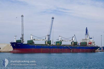
LOTUS G
Bulk Carrier
Current Trip
| Trip Time | 6 days |
|---|---|
| Trip Distance | 1786.03 nm |
| AVG Speed | 11 Noeuds |
| MAX Speed | 11 Noeuds |
| Tirant d eau | 6.3 m |
| AVG Wind | 9.6 knots |
| MAX Wind | 19 knots |
| MIN Temp | 20.1°C / 68.18°F |
| MAX Temp | 30.9°C / 87.62°F |
| Position reçue | 2 d depuis |
Current Position
| Longitude | 28.67837° |
|---|---|
| Latitude | 44.10392° |
| Etat | Under way using engine |
| Vitesse | 5.2 Noeuds |
| Parcours | 284° |
| Zone | Black Sea |
| Station | T-AIS |
| Position reçue | 2 d depuis |
Info
Information
The current position of LOTUS G is in Black Sea with coordinates 44.10392° / 28.67837° as reported on 2024-07-13 09:22 by AIS to our vessel tracker app. The vessel's current speed is 5.2 Noeuds and is currently inside the port of CONSTANTA.
The vessel LOTUS G (IMO: 9387360, MMSI: 215847000) is a Bulk Carrier that was built in 2009 ( 15 Age ). It's sailing under the flag of [MT] Malta.
In this page you can find informations about the vessels current position, last detected port calls, and current voyage information. If the vessels is not in coverage by AIS you will find the latest position.
The current position of LOTUS G is detected by our AIS receivers and we are not responsible for the reliability of the data. The last position was recorded while the vessel was in Coverage by the Ais receivers of our vessel tracking app.
The current draught of LOTUS G as reported by AIS is 6.3 meters
Weather
| Temperature | 28.1°C / 82.58°F |
|---|---|
| Wind Speed | 10 knots |
| Direction | 55° NE |
| Pressure | 1012.2 hPa |
| Humidity | 61 % |
| Cloud Coverage | 71 % |
Featured Company
Last Port Calls
| Port | Arrival | Departure | Time In Port |
|---|---|---|---|
| 2024-07-13 09:09 | |||
| 2024-07-02 22:09 | 2024-07-07 00:17 | 4 d | |
| 2024-06-26 07:26 | |||
| 2024-06-12 06:29 | 2024-06-14 19:13 | 2 d | |
| 2024-06-03 21:02 | 2024-06-03 22:14 | 1 h | |
| 2024-05-26 09:36 | 2024-06-02 01:29 | 6 d | |
| 2024-05-15 09:09 | 2024-05-18 05:36 | 2 d | |
| 2024-05-06 07:30 | 2024-05-11 16:51 | 5 d |
Most Visited Ports (Last year)
| Port | Arrivals | |
|---|---|---|
| 7 | ||
| 7 | ||
| 4 | ||
| 3 | ||
| 3 | ||
| 2 |
Last Trips
| Origin | Departure | Destination | Arrival | Distance | |
|---|---|---|---|---|---|
| 2024-07-07 02:17 | 2024-07-13 12:09 | 1786.03 nm | |||
| 2024-06-26 10:26 | 2024-07-03 00:09 | 1370.65 nm | |||
| 2024-06-04 01:14 | 2024-06-12 08:29 | 1604.31 nm | |||
| 2024-06-02 04:29 | 2024-06-04 00:02 | 201.92 nm | |||
| 2024-05-18 07:36 | 2024-05-26 12:36 | 1448.49 nm | |||
| 2024-05-11 19:51 | 2024-05-15 11:09 | 955.73 nm | |||
| 2024-04-30 21:44 | 2024-05-06 10:30 | 1377.77 nm |
Events
| Heure | Evenement | Détails | Position/ Destination | Info |
|---|---|---|---|---|
| 2024-07-13 10:06 | Arret |
44.10045 / 28.65490
[RO] CONSTANTA
|
Vitesse: 0.2 kn Parcours: 210° |
|
| 2024-07-13 09:26 | Etat Changé | Default Under way using engine |
44.10587 / 28.67171
[RO] CONSTANTA
|
Vitesse: 5.2 kn Parcours: 284° |
| 2024-07-13 09:22 | Hors de la zone couverte |
44.10392 / 28.67837
Black Sea
[RO] CONSTANTA
|
Vitesse: 5.2 kn Parcours: 270.3° |
|
| 2024-07-13 09:09 | Port d'arrivée |
|
44.10234 / 28.70196
[RO] CONSTANTA
|
Vitesse: 6.2 kn Parcours: 332.3° |
| 2024-07-13 08:30 | Etat Changé | Under way using engine Default |
44.03238 / 28.78246
ROCND
|
Vitesse: 12.8 kn Parcours: 323° |
| 2024-07-13 08:26 | Etat Changé | Default Under way using engine |
44.02132 / 28.79362
ROCND
|
Vitesse: 12.8 kn Parcours: 321.9° |
| 2024-07-13 08:22 | Changement de zone | Romanian part of the Black Sea Turkish part of the Black Sea |
44.01004 / 28.80569
Black Sea
ROCND
|
Vitesse: 12.8 kn Parcours: 321.9° |
| 2024-07-13 08:22 | Etat Changé | Under way using engine Default |
44.01004 / 28.80569
ROCND
|
Vitesse: 12.8 kn Parcours: 324° |
| 2024-07-13 08:22 | Dans la zone couverte |
44.01004 / 28.80569
Black Sea
ROCND
|
Vitesse: 12.8 kn Parcours: 321.9° |
|
| 2024-07-12 18:58 | Hors de la zone couverte |
41.49729 / 29.21031
Black Sea
ROCND
|
Vitesse: 12.3 kn Parcours: 358.8° |