
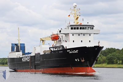
LINK POLARIS
Ro-Ro Cargo
Current Trip
| Time Travelled | 20 h, 19 mins |
|---|---|
| Remaining Time | 1 day |
| Distance Travelled | 266.49 nm |
| Remaining Distance | 424.83 nm |
| AVG Speed | 13.2 Noeuds |
| MAX Speed | 14.2 Noeuds |
| AVG Wind | 9.2 knots |
| MAX Wind | 14 knots |
| MIN Temp | 8.8°C / 47.84°F |
| MAX Temp | 10.4°C / 50.72°F |
| Tirant d eau | 4.6 m |
| Position reçue | Maintenant |
Current Position
| Longitude | --- |
|---|---|
| Latitude | --- |
| Etat | Under way using engine |
| Vitesse | 13.9 Noeuds |
| Parcours | 273.2° |
| Zone | Baltic Sea |
| Station | T-AIS |
| Position reçue | Maintenant |
Info
Information
The current position of LINK POLARIS is in Baltic Sea with coordinates 55.25254° / 13.40808° as reported on 2024-11-07 15:55 by AIS to our vessel tracker app. The vessel's current speed is 13.9 Noeuds and is heading at the port of HUSOYA. The estimated time of arrival as calculated by MyShipTracking vessel tracking app is 2024-11-08 23:29 LT
The vessel LINK POLARIS (IMO: 7915541, MMSI: 257689000) is a Ro-Ro Cargo that was built in 1980 ( 44 Age ). It's sailing under the flag of [NO] Norway.
In this page you can find informations about the vessels current position, last detected port calls, and current voyage information. If the vessels is not in coverage by AIS you will find the latest position.
The current position of LINK POLARIS is detected by our AIS receivers and we are not responsible for the reliability of the data. The last position was recorded while the vessel was in Coverage by the Ais receivers of our vessel tracking app.
The current draught of LINK POLARIS as reported by AIS is 4.6 meters
Weather
| Temperature | 10.3°C / 50.54°F |
|---|---|
| Wind Speed | 5 knots |
| Direction | 313° NW |
| Pressure | 1033.3 hPa |
| Humidity | 83.9 % |
| Cloud Coverage | 100 % |
Featured Company
Last Port Calls
| Port | Arrival | Departure | Time In Port |
|---|---|---|---|
| 2024-11-05 21:00 | 2024-11-06 19:37 | 22 h | |
| 2024-11-04 10:19 | 2024-11-04 22:14 | 11 h | |
| 2024-11-02 17:25 | 2024-11-03 00:10 | 6 h | |
| 2024-11-01 08:59 | 2024-11-01 10:11 | 1 h | |
| 2024-10-29 07:01 | 2024-11-01 08:40 | 3 d | |
| 2024-10-28 10:21 | 2024-10-28 11:01 | 40 m | |
| 2024-10-26 11:53 | 2024-10-26 13:13 | 1 h | |
| 2024-10-25 16:56 | 2024-10-25 20:17 | 3 h | |
| 2024-10-21 18:46 | |||
| 2024-10-21 05:39 | 2024-10-21 09:55 | 4 h |
Last Trips
| Origin | Departure | Destination | Arrival | Distance | |
|---|---|---|---|---|---|
| 2024-11-04 23:14 | 2024-11-05 23:00 | 296.65 nm | |||
| 2024-11-03 01:10 | 2024-11-04 11:19 | 399.16 nm | |||
| 2024-11-01 11:11 | 2024-11-02 18:25 | 300.56 nm | |||
| 2024-11-01 09:40 | 2024-11-01 09:59 | 0.85 nm | |||
| 2024-10-28 12:01 | 2024-10-29 08:01 | 172.07 nm | |||
| 2024-10-26 15:13 | 2024-10-28 11:21 | 165.66 nm | |||
| 2024-10-25 22:17 | 2024-10-26 13:53 | 174.40 nm | |||
| 2024-10-21 11:55 | 2024-10-25 18:56 | 382.22 nm | |||
| 2024-10-21 11:55 | 2024-10-21 20:46 | 95.78 nm | |||
| 2024-10-21 02:06 | 2024-10-21 07:39 | 63.98 nm |
Events
| Heure | Evenement | Détails | Position/ Destination | Info |
|---|---|---|---|---|
| 2024-11-07 12:32 | Detecté en mer | Swedish part of the Baltic Sea |
55.42786 / 14.62897
Baltic Sea
HUSOEY
|
Vitesse: 13.3 kn Parcours: 259.6° |
| 2024-11-07 09:14 | Detecté en mer | Danish part of the Kattegat |
55.49118 / 15.90146
Kattegat
HUSOEY
|
Vitesse: 13.4 kn Parcours: 264.4° |
| 2024-11-07 08:57 | Tirant d'eau modifié | 4.6 4.8 |
55.49664 / 16.00939
HUSOEY
|
Vitesse: 13.5 kn Parcours: 264.5° |
| 2024-11-07 08:29 | Detecté en mer | Swedish part of the Baltic Sea |
55.50552 / 16.19486
Baltic Sea
HUSOEY
|
Vitesse: 13.7 kn Parcours: 266.1° |
| 2024-11-07 08:29 | Dans la zone couverte |
55.50552 / 16.19486
Baltic Sea
HUSOEY
|
Vitesse: 13.7 kn Parcours: 266.1° |
|
| 2024-11-07 05:15 | Hors de la zone couverte |
55.56233 / 17.45909
Baltic Sea
HUSOEY
|
Vitesse: 13.1 kn Parcours: 265.4° |
|
| 2024-11-07 01:38 | Detecté en mer | Polish part of the Baltic Sea |
55.62978 / 18.80394
Baltic Sea
HUSOEY
|
Vitesse: 12.7 kn Parcours: 265.2° |
| 2024-11-07 01:37 | Dans la zone couverte |
55.62978 / 18.80394
Baltic Sea
HUSOEY
|
Vitesse: 12.7 kn Parcours: 265.2° |
|
| 2024-11-07 00:23 | Hors de la zone couverte |
55.65298 / 19.27107
Baltic Sea
HUSOEY
|
Vitesse: 12.7 kn Parcours: 264.7° |
|
| 2024-11-06 23:02 | Detecté en mer | Russian part of the Baltic Sea |
55.67886 / 19.78693
Baltic Sea
HUSOEY
|
Vitesse: 12.9 kn Parcours: 264.5° |