

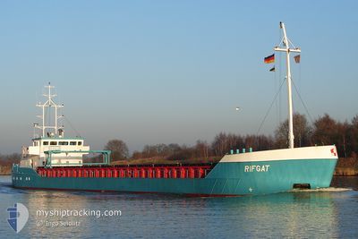
LELIE C
General Cargo

Current Trip
| Trip Time | 2 days |
|---|---|
| Trip Distance | 468.11 nm |
| AVG Speed | 7.2 Noeuds |
| MAX Speed | 10.4 Noeuds |
| Tirant d eau | 3.8 m |
| AVG Wind | 24.1 knots |
| MAX Wind | 35 knots |
| MIN Temp | 3.1°C / 37.58°F |
| MAX Temp | 12.6°C / 54.68°F |
| Position reçue | 2 m depuis |
Current Position
| Longitude | --- |
|---|---|
| Latitude | --- |
| Etat | Moored |
| Vitesse | |
| Parcours | 275° |
| Zone | North Sea |
| Station | T-AIS |
| Position reçue | 2 m depuis |
Information
The current position of LELIE C is in North Sea with coordinates 52.38347° / 4.94948° as reported on 2025-03-27 14:48 by AIS to our vessel tracker app. The vessel's current speed is 0 Noeuds and is currently inside the port of AMSTERDAM.
The vessel LELIE C (IMO: 9166443, MMSI: 246449000) is a General Cargo that was built in 2000 ( 25 Age ). It's sailing under the flag of [NL] Netherlands.
In this page you can find informations about the vessels current position, last detected port calls, and current voyage information. If the vessels is not in coverage by AIS you will find the latest position.
The current position of LELIE C is detected by our AIS receivers and we are not responsible for the reliability of the data. The last position was recorded while the vessel was in Coverage by the Ais receivers of our vessel tracking app.
The current draught of LELIE C as reported by AIS is 2.8 meters
Weather
| Temperature | 14°C / 57.2°F |
|---|---|
| Wind Speed | 7 knots |
| Direction | 258° WSW |
| Pressure | 1019.2 hPa |
| Humidity | 47.6 % |
| Cloud Coverage | 12 % |


Featured Company
Last Port Calls
| Port | Arrival | Departure | Time In Port |
|---|---|---|---|
| 2025-03-24 14:03 | |||
| 2025-03-20 09:37 | 2025-03-21 22:04 | 1 d | |
| 2025-03-16 21:24 | 2025-03-18 20:12 | 1 d | |
| 2025-03-14 17:19 | 2025-03-15 00:53 | 7 h | |
| 2025-03-13 19:45 | 2025-03-14 15:02 | 19 h | |
| 2025-03-10 10:39 | 2025-03-11 17:23 | 1 d | |
| 2025-03-06 19:35 | 2025-03-08 15:50 | 1 d | |
| 2025-03-02 13:35 | 2025-03-04 16:10 | 2 d | |
| 2025-02-24 08:36 | 2025-02-28 16:03 | 4 d | |
| 2025-02-21 08:04 | 2025-02-21 19:42 | 11 h |
Most Visited Ports (Last year)
| Port | Arrivals | |
|---|---|---|
| 34 | ||
| 26 | ||
| 12 | ||
| 9 | ||
| 3 | ||
| 2 |
Last Trips
| Origin | Departure | Destination | Arrival | Distance | |
|---|---|---|---|---|---|
| 2025-03-21 22:04 | 2025-03-24 14:03 | 468.11 nm | |||
| 2025-03-18 20:12 | 2025-03-20 09:37 | 338.47 nm | |||
| 2025-03-15 00:53 | 2025-03-16 21:24 | 372.38 nm | |||
| 2025-03-14 15:02 | 2025-03-14 17:19 | 11.63 nm | |||
| 2025-03-11 17:23 | 2025-03-13 19:45 | 396.67 nm | |||
| 2025-03-08 15:50 | 2025-03-10 10:39 | 397.45 nm | |||
| 2025-03-04 16:10 | 2025-03-06 19:35 | 400.61 nm | |||
| 2025-02-28 16:03 | 2025-03-02 13:35 | 238.64 nm | |||
| 2025-02-21 19:42 | 2025-02-24 08:36 | 409.69 nm | |||
| 2025-02-21 06:23 | 2025-02-21 08:04 | 11.46 nm |
Events
| Heure | Evenement | Détails | Position/ Destination | Info |
|---|---|---|---|---|
| 2025-03-25 08:44 | Tirant d'eau modifié | 2.8 3.6 |
52.38495 / 4.94749
[NL] AMSTERDAM
|
Vitesse: Parcours: 186° |
| 2025-03-24 14:12 | Etat Changé | Moored Under way using engine |
52.38496 / 4.94754
[NL] AMSTERDAM
|
Vitesse: Parcours: 186° |
| 2025-03-24 14:11 | Tirant d'eau modifié | 3.6 3.8 |
52.38499 / 4.94756
[NL] AMSTERDAM
|
Vitesse: Parcours: 186° |
| 2025-03-24 13:44 | Arret |
52.38486 / 4.94764
[NL] AMSTERDAM
|
Vitesse: 0.2 kn Parcours: 188° |
|
| 2025-03-24 13:03 | Port d'arrivée |
|
52.41294 / 4.86427
[NL] AMSTERDAM
|
Vitesse: 9.7 kn Parcours: 121.5° |
| 2025-03-24 12:00 | Démarrage | 0.93 nm, East of IJMUIDEN |
52.46728 / 4.61278
AMSTERDAM
|
Vitesse: 4.8 kn Parcours: 96° |
| 2025-03-24 11:38 | Arret | 0.8 nm, East of IJMUIDEN |
52.46758 / 4.60920
AMSTERDAM
|
Vitesse: 0.2 kn Parcours: 89° |
| 2025-03-24 09:46 | Changement d'ETA | 2025/03/24 14:30 2025/03/24 17:00 |
52.67630 / 4.49470
AMSTERDAM
|
Vitesse: 8.6 kn Parcours: 179.4° |
| 2025-03-24 09:36 | Etat Changé | Under way using engine Default |
52.69799 / 4.49401
AMSTERDAM
|
Vitesse: 8.6 kn Parcours: 178° |
| 2025-03-24 09:28 | Dans la zone couverte |
52.69720 / 4.49405
North Sea
AMSTERDAM
|
Vitesse: 8.6 kn Parcours: 177.7° |