
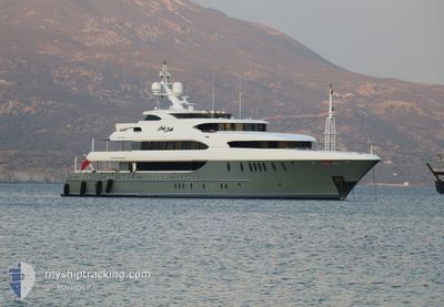
LADY BETH
Yacht
Current Trip
| Trip Time | 3 days |
|---|---|
| Trip Distance | 732.50 nm |
| AVG Speed | 9 Noeuds |
| MAX Speed | 10.9 Noeuds |
| Tirant d eau | 3.1 m |
| AVG Wind | 12.9 knots |
| MAX Wind | 18 knots |
| MIN Temp | 19.7°C / 67.46°F |
| MAX Temp | 24.4°C / 75.92°F |
| Position reçue | 4 m depuis |
Current Position
| Longitude | --- |
|---|---|
| Latitude | --- |
| Etat | Moored |
| Vitesse | 0.1 Noeuds |
| Parcours | 299° |
| Zone | North Atlantic Ocean |
| Station | T-AIS |
| Position reçue | 4 m depuis |
Info
Information
The current position of LADY BETH is in North Atlantic Ocean with coordinates 28.46496° / -16.24489° as reported on 2024-10-05 07:12 by AIS to our vessel tracker app. The vessel's current speed is 0.1 Noeuds and is currently inside the port of TENERIFE.
The vessel LADY BETH (IMO: 9643532, MMSI: 319931000) is a Yacht that was built in 2011 ( 13 Age ). It's sailing under the flag of [KY] Cayman Is.
In this page you can find informations about the vessels current position, last detected port calls, and current voyage information. If the vessels is not in coverage by AIS you will find the latest position.
The current position of LADY BETH is detected by our AIS receivers and we are not responsible for the reliability of the data. The last position was recorded while the vessel was in Coverage by the Ais receivers of our vessel tracking app.
The current draught of LADY BETH as reported by AIS is 3.1 meters
Weather
| Temperature | 21.5°C / 70.7°F |
|---|---|
| Wind Speed | 9 knots |
| Direction | 53° NE |
| Pressure | 1017.7 hPa |
| Humidity | 89.4 % |
| Cloud Coverage | 61 % |
Featured Company
Last Port Calls
| Port | Arrival | Departure | Time In Port |
|---|---|---|---|
| 2024-09-29 22:45 | |||
| 2024-09-26 06:53 | 2024-09-26 18:04 | 11 h | |
| 2024-09-23 06:11 | 2024-09-24 06:51 | 1 d | |
| 2024-09-20 09:03 | |||
| 2024-09-16 07:40 | 2024-09-16 15:28 | 7 h | |
| 2024-09-13 21:29 | 2024-09-15 03:18 | 1 d | |
| 2024-09-08 04:15 | 2024-09-08 19:20 | 15 h | |
| 2024-09-06 16:51 | 2024-09-07 15:46 | 22 h | |
| 2024-09-02 16:16 | 2024-09-02 16:44 | 27 m | |
| 2024-08-29 09:12 | 2024-08-30 08:51 | 23 h |
Most Visited Ports (Last year)
| Port | Arrivals | |
|---|---|---|
| 3 | ||
| 3 | ||
| 3 | ||
| 2 | ||
| 2 | ||
| 2 |
Last Trips
| Origin | Departure | Destination | Arrival | Distance | |
|---|---|---|---|---|---|
| 2024-09-26 20:04 | 2024-09-29 23:45 | 732.50 nm | |||
| 2024-09-24 08:51 | 2024-09-26 08:53 | 444.06 nm | |||
| 2024-09-20 11:03 | 2024-09-23 08:11 | 338.73 nm | |||
| 2024-09-15 06:18 | 2024-09-16 09:40 | 246.72 nm | |||
| 2024-09-08 22:20 | 2024-09-14 00:29 | 319.48 nm | |||
| 2024-09-07 18:46 | 2024-09-08 07:15 | 88.65 nm | |||
| 2024-09-02 19:44 | 2024-09-06 19:51 | 209.41 nm | |||
| 2024-08-30 11:51 | 2024-09-02 19:16 | 202.23 nm | |||
| 2024-08-11 10:55 | 2024-08-29 12:12 | 1205.69 nm | |||
| 2024-08-01 09:55 | 2024-08-08 13:11 | 86.69 nm |
Events
| Heure | Evenement | Détails | Position/ Destination | Info |
|---|---|---|---|---|
| 2024-10-01 00:39 | Changement d'ETA | 2025/09/29 23:30 2024/09/29 23:30 |
28.46502 / -16.24492
[ES] TENERIFE
|
Vitesse: Parcours: 298° |
| 2024-09-29 23:21 | Etat Changé | Moored Under way using engine |
28.46502 / -16.24490
[ES] TENERIFE
|
Vitesse: 0.1 kn Parcours: 299° |
| 2024-09-29 22:58 | Arret |
28.46480 / -16.24488
[ES] TENERIFE
|
Vitesse: 0.3 kn Parcours: 336° |
|
| 2024-09-29 22:45 | Port d'arrivée |
|
28.45375 / -16.24687
[ES] TENERIFE
|
Vitesse: 6 kn Parcours: 317.8° |
| 2024-09-29 21:43 | Changement d'ETA | 2024/09/29 23:30 2024/09/29 22:30 |
28.43528 / -16.06855
FT LAUDERDALE
|
Vitesse: 9.5 kn Parcours: 266° |
| 2024-09-29 20:09 | Dans la zone couverte |
28.55472 / -15.82667
North Atlantic Ocean
FT LAUDERDALE
|
Vitesse: 9.5 kn Parcours: 222.7° |
|
| 2024-09-29 15:54 | Hors de la zone couverte |
29.11710 / -15.37409
North Atlantic Ocean
FT LAUDERDALE
|
Vitesse: 9.5 kn Parcours: 214.4° |
|
| 2024-09-29 14:57 | Changement de zone | Spanish (Canary Islands) part of the North Atlantic Ocean Portuguese (Madeira) part of the North Atlantic Ocean |
29.24562 / -15.27366
North Atlantic Ocean
FT LAUDERDALE
|
Vitesse: 10.3 kn Parcours: 218° |
| 2024-09-29 11:27 | Detecté en mer | Portuguese (Madeira) part of the North Atlantic Ocean |
29.72228 / -14.89528
North Atlantic Ocean
FT LAUDERDALE
|
Vitesse: 10.2 kn Parcours: 213.2° |
| 2024-09-29 11:27 | Dans la zone couverte |
29.72228 / -14.89528
North Atlantic Ocean
FT LAUDERDALE
|
Vitesse: 10.2 kn Parcours: 213.2° |