
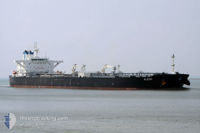
KLEON
Tanker
Current Trip
| Time Travelled | 15 days |
|---|---|
| Remaining Time | 2 days |
| Distance Travelled | 3792.71 nm |
| Remaining Distance | 1557.06 nm |
| AVG Speed | 11.6 Noeuds |
| MAX Speed | 14.3 Noeuds |
| AVG Wind | 9.4 knots |
| MAX Wind | 29 knots |
| MIN Temp | 26.6°C / 79.88°F |
| MAX Temp | 33.7°C / 92.66°F |
| Tirant d eau | 12.5 m |
| Position reçue | 2 d depuis |
Current Position
| Longitude | 104.32669° |
|---|---|
| Latitude | 1.28957° |
| Etat | Under way using engine |
| Vitesse | 11.7 Noeuds |
| Parcours | 57.8° |
| Zone | Singapore Strait |
| Station | T-AIS |
| Position reçue | 2 d depuis |
Info
Information
The current position of KLEON is in Singapore Strait with coordinates 1.28957° / 104.32669° as reported on 2024-06-03 09:36 by AIS to our vessel tracker app. The vessel's current speed is 11.7 Noeuds and is heading at the port of KAOHSIUNG. The estimated time of arrival as calculated by MyShipTracking vessel tracking app is 2024-06-08 19:57 LT
The vessel KLEON (IMO: 9730945, MMSI: 538006032) is a Tanker It's sailing under the flag of [MH] Marshall Is.
In this page you can find informations about the vessels current position, last detected port calls, and current voyage information. If the vessels is not in coverage by AIS you will find the latest position.
The current position of KLEON is detected by our AIS receivers and we are not responsible for the reliability of the data. The last position was recorded while the vessel was in Coverage by the Ais receivers of our vessel tracking app.
The current draught of KLEON as reported by AIS is 12.5 meters
Weather
| Temperature | 30°C / 86°F |
|---|---|
| Wind Speed | 13 knots |
| Direction | 218° SW |
| Pressure | 1010.2 hPa |
| Humidity | 79.7 % |
| Cloud Coverage | 20 % |
Featured Company
Last Trips
| Origin | Departure | Destination | Arrival | Distance |
|---|
Events
| Heure | Evenement | Détails | Position/ Destination | Info |
|---|---|---|---|---|
| 2024-06-03 09:39 | Etat Changé | Default Under way using engine |
1.29377 / 104.33290
TWKHH
|
Vitesse: 11.7 kn Parcours: 57.8° |
| 2024-06-03 09:36 | Hors de la zone couverte |
1.28957 / 104.32669
Singapore Strait
TWKHH
|
Vitesse: 11.7 kn Parcours: 57.8° |
|
| 2024-06-03 08:41 | Changement de zone | Malaysian part of the Singapore Strait Indonesian part of the Singapore Strait |
1.26259 / 104.14529
Singapore Strait
TWKHH
|
Vitesse: 12.4 kn Parcours: 81.3° |
| 2024-06-03 07:53 | Changement de zone | Indonesian part of the Singapore Strait Singaporean part of the Singapore Strait |
1.24778 / 103.99201
Singapore Strait
TWKHH
|
Vitesse: 8.2 kn Parcours: 105.1° |
| 2024-06-03 07:22 | Démarrage | 2.93 nm, South West of TANAH MERAH |
1.28062 / 103.98051
TWKHH
|
Vitesse: 3.1 kn Parcours: 195° |
| 2024-06-03 07:06 | Etat Changé | Under way using engine At anchor |
1.28341 / 103.98389
TWKHH
|
Vitesse: 0.3 kn Parcours: 238° |
| 2024-06-03 06:36 | Changement de destination | TWKHH SGSIN |
1.28333 / 103.98456
TWKHH
|
Vitesse: Parcours: 245° |
| 2024-06-03 06:36 | Changement d'ETA | 2024/06/08 14:00 2024/06/02 19:15 |
1.28333 / 103.98456
TWKHH
|
Vitesse: Parcours: 245° |
| 2024-06-02 19:46 | Etat Changé | At anchor Under way using engine |
1.28186 / 103.98377
SGSIN
|
Vitesse: 0.3 kn Parcours: 284° |
| 2024-06-02 19:45 | Arret | 2.74 nm, South West of TANAH MERAH |
1.28189 / 103.98366
SGSIN
|
Vitesse: 0.3 kn Parcours: 280° |