

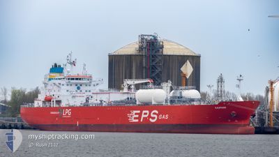
KAUPANG
Tanker

Current Trip
| Time Travelled | 7 days |
|---|---|
| Remaining Time | --- |
| Distance Travelled | 802.24 nm |
| Remaining Distance | --- |
| AVG Speed | 13.5 Noeuds |
| MAX Speed | 15.7 Noeuds |
| AVG Wind | 11.1 knots |
| MAX Wind | 28.7 knots |
| MIN Temp | 3.7°C / 38.66°F |
| MAX Temp | 14.7°C / 58.46°F |
| Tirant d eau | 8.2 m |
| Position reçue | 4 m depuis |
Current Position
| Longitude | --- |
|---|---|
| Latitude | --- |
| Etat | At anchor |
| Vitesse | 0.2 Noeuds |
| Parcours | 229° |
| Zone | Skaggerak |
| Station | T-AIS |
| Position reçue | 4 m depuis |
Information
The current position of KAUPANG is in Skaggerak with coordinates 57.92601° / 11.34851° as reported on 2025-03-27 10:51 by AIS to our vessel tracker app. The vessel's current speed is 0.2 Noeuds
The vessel KAUPANG (IMO: 9914620, MMSI: 636021568) is a Tanker It's sailing under the flag of [LR] Liberia.
In this page you can find informations about the vessels current position, last detected port calls, and current voyage information. If the vessels is not in coverage by AIS you will find the latest position.
The current position of KAUPANG is detected by our AIS receivers and we are not responsible for the reliability of the data. The last position was recorded while the vessel was in Coverage by the Ais receivers of our vessel tracking app.
The current draught of KAUPANG as reported by AIS is 8.2 meters
Weather
| Temperature | 5.8°C / 42.44°F |
|---|---|
| Wind Speed | 23 knots |
| Direction | 241° WSW |
| Pressure | 1011 hPa |
| Humidity | 94.4 % |
| Cloud Coverage | 100 % |


Featured Company
Last Port Calls
| Port | Arrival | Departure | Time In Port |
|---|---|---|---|
| 2025-03-18 16:01 | 2025-03-19 13:18 | 21 h | |
| 2025-03-14 08:28 | 2025-03-15 17:00 | 1 d | |
| 2025-03-11 02:17 | 2025-03-12 02:14 | 23 h | |
| 2025-03-06 18:48 | 2025-03-09 11:59 | 2 d | |
| 2025-03-03 12:10 | 2025-03-04 17:18 | 1 d | |
| 2025-02-28 10:06 | 2025-03-01 10:20 | 1 d | |
| 2025-02-17 08:37 | 2025-02-25 23:20 | 8 d | |
| 2025-02-13 04:03 | 2025-02-14 07:25 | 1 d | |
| 2025-02-03 08:40 | 2025-02-04 05:13 | 20 h | |
| 2025-02-01 10:18 | 2025-02-02 08:10 | 21 h |
Most Visited Ports (Last year)
| Port | Arrivals | |
|---|---|---|
| 13 | ||
| 7 | ||
| 4 | ||
| 4 | ||
| 3 | ||
| 2 |
Last Trips
| Origin | Departure | Destination | Arrival | Distance | |
|---|---|---|---|---|---|
| 2025-03-15 17:00 | 2025-03-18 16:01 | 554.41 nm | |||
| 2025-03-12 02:14 | 2025-03-14 08:28 | 700.26 nm | |||
| 2025-03-09 11:59 | 2025-03-11 02:17 | 503.51 nm | |||
| 2025-03-04 17:18 | 2025-03-06 18:48 | 600.20 nm | |||
| 2025-03-01 10:20 | 2025-03-03 12:10 | 685.02 nm | |||
| 2025-02-25 23:20 | 2025-02-28 10:06 | 307.53 nm | |||
| 2025-02-14 07:25 | 2025-02-17 08:37 | 514.71 nm | |||
| 2025-02-04 05:13 | 2025-02-13 04:03 | 981.39 nm | |||
| 2025-02-02 08:10 | 2025-02-03 08:40 | 301.28 nm | |||
| 2025-01-30 00:36 | 2025-02-01 10:18 | 600.95 nm |
Events
| Heure | Evenement | Détails | Position/ Destination | Info |
|---|---|---|---|---|
| 2025-03-27 10:27 | Etat Changé | At anchor Default |
57.92618 / 11.34824
SE STE
|
Vitesse: 0.3 kn Parcours: 227° |
| 2025-03-27 10:24 | Etat Changé | Default At anchor |
57.92610 / 11.34844
SE STE
|
Vitesse: Parcours: 232° |
| 2025-03-27 07:18 | Etat Changé | At anchor Under way using engine |
57.92379 / 11.34698
SE STE
|
Vitesse: 0.2 kn Parcours: 292° |
| 2025-03-27 07:14 | Arret | 7.17 nm, West of STANSVIKS |
57.92319 / 11.34650
SE STE
|
Vitesse: 0.3 kn Parcours: 268° |
| 2025-03-27 05:38 | Changement de zone | Swedish part of the Skaggerak Danish part of the Skaggerak |
57.98666 / 10.78317
Skaggerak
SE STE
|
Vitesse: 15.2 kn Parcours: 93.1° |
| 2025-03-26 23:34 | Changement de zone | Danish part of the Skaggerak Danish part of the North Sea |
57.32409 / 8.25435
Skaggerak
SE STE
|
Vitesse: 15.5 kn Parcours: 75.2° |
| 2025-03-26 13:34 | Detecté en mer | Danish part of the North Sea |
55.38120 / 6.46706
North Sea
SE STE
|
Vitesse: 14.6 kn Parcours: 334.6° |
| 2025-03-26 13:32 | Etat Changé | Under way using engine Default |
55.37426 / 6.47288
SE STE
|
Vitesse: 14.5 kn Parcours: 335° |
| 2025-03-26 13:17 | Etat Changé | Default Under way using engine |
55.31983 / 6.51854
SE STE
|
Vitesse: 14.5 kn Parcours: 334.6° |
| 2025-03-26 13:12 | Etat Changé | Under way using engine Default |
55.30196 / 6.53339
SE STE
|
Vitesse: 14.4 kn Parcours: 335° |