

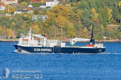
KARMSUND
Pallet Carrier

Current Trip
| Time Travelled | 10 h, 4 mins |
|---|---|
| Remaining Time | 3 h, 18 mins |
| Distance Travelled | 88.00 nm |
| Remaining Distance | 40.89 nm |
| AVG Speed | 10.3 Noeuds |
| MAX Speed | 12.7 Noeuds |
| AVG Wind | 23.1 knots |
| MAX Wind | 31 knots |
| MIN Temp | 1.4°C / 34.52°F |
| MAX Temp | 5.6°C / 42.08°F |
| Tirant d eau | 4.6 m |
| Position reçue | 1 m depuis |
Current Position
| Longitude | --- |
|---|---|
| Latitude | --- |
| Etat | Under way using engine |
| Vitesse | 12.1 Noeuds |
| Parcours | 198.5° |
| Zone | Norwegian Sea |
| Station | T-AIS |
| Position reçue | 1 m depuis |
Information
The current position of KARMSUND is in Norwegian Sea with coordinates 63.78689° / 9.55786° as reported on 2025-02-28 13:31 by AIS to our vessel tracker app. The vessel's current speed is 12.1 Noeuds and is heading at the port of ORKANGER. The estimated time of arrival as calculated by MyShipTracking vessel tracking app is 2025-02-28 17:50 LT
The vessel KARMSUND (IMO: 7724203, MMSI: 219023116) is a Pallet Carrier that was built in 1979 ( 46 Age ). It's sailing under the flag of [DK] Denmark.
In this page you can find informations about the vessels current position, last detected port calls, and current voyage information. If the vessels is not in coverage by AIS you will find the latest position.
The current position of KARMSUND is detected by our AIS receivers and we are not responsible for the reliability of the data. The last position was recorded while the vessel was in Coverage by the Ais receivers of our vessel tracking app.
The current draught of KARMSUND as reported by AIS is 4.6 meters
Weather
| Temperature | 4.6°C / 40.28°F |
|---|---|
| Wind Speed | 23 knots |
| Direction | 249° WSW |
| Pressure | 1018.7 hPa |
| Humidity | 94.5 % |
| Cloud Coverage | 100 % |


Featured Company
Last Port Calls
| Port | Arrival | Departure | Time In Port |
|---|---|---|---|
| 2025-02-28 00:45 | 2025-02-28 04:28 | 3 h | |
| 2025-02-27 06:00 | 2025-02-27 10:15 | 4 h | |
| 2025-02-25 06:03 | 2025-02-26 22:10 | 1 d | |
| 2025-02-24 10:35 | 2025-02-24 18:41 | 8 h | |
| 2025-02-21 17:22 | 2025-02-21 22:45 | 5 h | |
| 2025-02-21 08:33 | 2025-02-21 12:32 | 3 h | |
| 2025-02-21 02:22 | 2025-02-21 03:31 | 1 h | |
| 2025-02-20 13:13 | 2025-02-20 14:59 | 1 h | |
| 2025-02-20 07:17 | 2025-02-20 11:36 | 4 h | |
| 2025-02-19 18:36 | 2025-02-19 19:27 | 50 m |
Last Trips
| Origin | Departure | Destination | Arrival | Distance | |
|---|---|---|---|---|---|
| 2025-02-27 10:15 | 2025-02-28 00:45 | 164.45 nm | |||
| 2025-02-26 22:10 | 2025-02-27 06:00 | 89.58 nm | |||
| 2025-02-24 18:41 | 2025-02-25 06:03 | 93.76 nm | |||
| 2025-02-21 22:45 | 2025-02-24 10:35 | 619.06 nm | |||
| 2025-02-21 12:32 | 2025-02-21 17:22 | 55.49 nm | |||
| 2025-02-21 03:31 | 2025-02-21 08:33 | 57.68 nm | |||
| 2025-02-20 14:59 | 2025-02-21 02:22 | 134.40 nm | |||
| 2025-02-20 11:36 | 2025-02-20 13:13 | 18.11 nm | |||
| 2025-02-19 19:27 | 2025-02-20 07:17 | 91.27 nm | |||
| 2025-02-19 12:41 | 2025-02-19 18:36 | 72.73 nm |
Events
| Heure | Evenement | Détails | Position/ Destination | Info |
|---|---|---|---|---|
| 2025-02-28 10:58 | Changement de destination | ORKANGER ROAN |
64.16720 / 10.12444
ORKANGER
|
Vitesse: 11.5 kn Parcours: 211.2° |
| 2025-02-28 10:58 | Changement d'ETA | 2025/02/28 17:00 2025/02/28 09:00 |
64.16720 / 10.12444
ORKANGER
|
Vitesse: 11.5 kn Parcours: 211.2° |
| 2025-02-28 10:42 | Démarrage | 10.93 nm, South West of SANDVIKSBERGET |
64.18043 / 10.18752
ROAN
|
Vitesse: 7.2 kn Parcours: 343.3° |
| 2025-02-28 09:57 | Etat Changé | Under way using engine Default |
64.17423 / 10.18820
ROAN
|
Vitesse: 0.2 kn Parcours: 215° |
| 2025-02-28 09:52 | Etat Changé | Default Under way using engine |
64.17509 / 10.18971
ROAN
|
Vitesse: 0.9 kn Parcours: 225° |
| 2025-02-28 09:33 | Arret | 11.19 nm, South West of SANDVIKSBERGET |
64.17448 / 10.18867
ROAN
|
Vitesse: 0.3 kn Parcours: 213° |
| 2025-02-28 09:16 | Etat Changé | Under way using engine Default |
64.17299 / 10.18658
ROAN
|
Vitesse: 5.1 kn Parcours: 165° |
| 2025-02-28 09:03 | Etat Changé | Default Under way using engine |
64.17813 / 10.18845
ROAN
|
Vitesse: 5.3 kn Parcours: 165.9° |
| 2025-02-28 04:28 | Tirant d'eau modifié | 4.6 4.8 |
64.54066 / 11.12439
ROAN
|
Vitesse: 12.5 kn Parcours: 339.8° |
| 2025-02-28 04:21 | Changement d'ETA | 2025/02/28 09:00 2025/02/28 12:00 |
64.52157 / 11.14688
ROAN
|
Vitesse: 12.6 kn Parcours: 326.8° |