
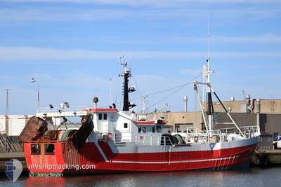
HG 410 SIGNET
Fishing
Current Trip
FISHING-KEEP DISTANC
| Time Travelled | 2 days |
|---|---|
| Remaining Time | --- |
| Distance Travelled | 248.06 nm |
| Remaining Distance | --- |
| AVG Speed | 7 Noeuds |
| MAX Speed | 9.8 Noeuds |
| AVG Wind | 17.8 knots |
| MAX Wind | 34 knots |
| MIN Temp | 3.5°C / 38.3°F |
| MAX Temp | 6.2°C / 43.16°F |
| Tirant d eau | 0 m |
| Position reçue | 1 m depuis |
Current Position
| Longitude | --- |
|---|---|
| Latitude | --- |
| Etat | Engaged in Fishing |
| Vitesse | 9 Noeuds |
| Parcours | 91.4° |
| Zone | North Sea |
| Station | T-AIS |
| Position reçue | 1 m depuis |
Info
Information
The current position of HG 410 SIGNET is in North Sea with coordinates 57.49226° / 7.17899° as reported on 2025-03-17 14:13 by AIS to our vessel tracker app. The vessel's current speed is 9 Noeuds
The vessel HG 410 SIGNET (MMSI: 219443000) is a Fishing It's sailing under the flag of [DK] Denmark.
In this page you can find informations about the vessels current position, last detected port calls, and current voyage information. If the vessels is not in coverage by AIS you will find the latest position.
The current position of HG 410 SIGNET is detected by our AIS receivers and we are not responsible for the reliability of the data. The last position was recorded while the vessel was in Coverage by the Ais receivers of our vessel tracking app.
Weather
| Temperature | 5.6°C / 42.08°F |
|---|---|
| Wind Speed | 23 knots |
| Direction | 278° W |
| Pressure | 1030.8 hPa |
| Humidity | 72.9 % |
| Cloud Coverage | 7 % |
Featured Company
Last Port Calls
| Port | Arrival | Departure | Time In Port |
|---|---|---|---|
| 2025-03-14 05:57 | 2025-03-15 09:05 | 1 d | |
| 2025-03-11 11:36 | 2025-03-11 12:29 | 53 m | |
| 2025-02-27 14:24 | 2025-03-07 21:54 | 8 d | |
| 2025-02-26 05:53 | 2025-02-26 16:05 | 10 h | |
| 2025-02-24 06:47 | 2025-02-24 10:01 | 3 h | |
| 2025-02-20 09:54 | 2025-02-21 08:59 | 23 h | |
| 2025-02-19 07:03 | 2025-02-19 08:26 | 1 h | |
| 2025-02-17 07:01 | 2025-02-17 10:23 | 3 h | |
| 2025-02-13 13:07 | 2025-02-13 14:37 | 1 h | |
| 2025-02-10 10:44 | 2025-02-11 18:49 | 1 d |
Last Trips
| Origin | Departure | Destination | Arrival | Distance | |
|---|---|---|---|---|---|
| 2025-03-11 12:29 | 2025-03-14 05:57 | 228.39 nm | |||
| 2025-03-07 21:54 | 2025-03-11 11:36 | 339.02 nm | |||
| 2025-02-26 16:05 | 2025-02-27 14:24 | 93.98 nm | |||
| 2025-02-24 10:01 | 2025-02-26 05:53 | 178.43 nm | |||
| 2025-02-21 08:59 | 2025-02-24 06:47 | 269.44 nm | |||
| 2025-02-19 08:26 | 2025-02-20 09:54 | 108.62 nm | |||
| 2025-02-17 10:23 | 2025-02-19 07:03 | 186.96 nm | |||
| 2025-02-13 14:37 | 2025-02-17 07:01 | 374.26 nm | |||
| 2025-02-11 18:49 | 2025-02-13 13:07 | 180.66 nm | |||
| 2025-02-07 19:22 | 2025-02-10 10:44 | 351.25 nm |
Events
| Heure | Evenement | Détails | Position/ Destination | Info |
|---|---|---|---|---|
| 2025-03-15 18:28 | Detecté en mer | Norwegian part of the North Sea |
57.51739 / 7.87939
North Sea
|
Vitesse: 6.7 kn Parcours: 262.2° |
| 2025-03-15 17:16 | Changement de zone | Norwegian part of the Skaggerak Danish part of the Skaggerak |
57.53189 / 8.11510
Skaggerak
|
Vitesse: 6.4 kn Parcours: 266° |
| 2025-03-15 08:05 | PORT DE DEPART |
|
57.60021 / 9.95873
FISHING-KEEP DISTANC
|
Vitesse: 7.9 kn Parcours: 347° |
| 2025-03-15 08:02 | Démarrage |
57.59505 / 9.96326
[DK] HIRTSHALS
|
Vitesse: 5.1 kn Parcours: 21° |
|
| 2025-03-14 05:03 | Arret |
57.59329 / 9.96398
[DK] HIRTSHALS
|
Vitesse: 0.3 kn Parcours: 134° |
|
| 2025-03-14 04:57 | Port d'arrivée |
|
57.59851 / 9.95856
[DK] HIRTSHALS
|
Vitesse: 6.4 kn Parcours: 166.3° |
| 2025-03-13 23:46 | Changement de zone | Danish part of the Skaggerak Swedish part of the Skaggerak |
58.04098 / 10.69011
Skaggerak
|
Vitesse: 5.1 kn Parcours: 222.7° |
| 2025-03-13 19:25 | Démarrage | 3.84 nm, South West of SMOGEN |
58.30065 / 11.16120
FISHING-KEEP DISTANC
|
Vitesse: 6 kn Parcours: 242.3° |
| 2025-03-13 18:46 | Arret | 3.8 nm, South West of SMOGEN |
58.30028 / 11.16465
FISHING-KEEP DISTANC
|
Vitesse: 0.3 kn Parcours: 331° |
| 2025-03-13 18:07 | Démarrage | 0.35 nm, North East of SMOGEN |
58.35643 / 11.23903
FISHING-KEEP DISTANC
|
Vitesse: 4.7 kn Parcours: 183° |