

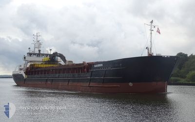
HAVBRIS
General Cargo

Current Trip
INVERKEITHING
| Time Travelled | 4 days |
|---|---|
| Remaining Time | --- |
| Distance Travelled | 922.39 nm |
| Remaining Distance | --- |
| AVG Speed | 9.7 Noeuds |
| MAX Speed | 11.6 Noeuds |
| AVG Wind | 10.3 knots |
| MAX Wind | 24.7 knots |
| MIN Temp | 2.3°C / 36.14°F |
| MAX Temp | 11.5°C / 52.7°F |
| Tirant d eau | 4.2 m |
| Position reçue | 1 h, 59 m depuis |
Current Position
| Longitude | --- |
|---|---|
| Latitude | --- |
| Etat | Under way using engine |
| Vitesse | 9.6 Noeuds |
| Parcours | 254.8° |
| Zone | North Sea |
| Station | T-AIS |
| Position reçue | 1 h, 59 m depuis |
Information
The current position of HAVBRIS is in North Sea with coordinates 56.02118° / -3.31631° as reported on 2025-03-27 12:19 by AIS to our vessel tracker app. The vessel's current speed is 9.6 Noeuds
The vessel HAVBRIS (IMO: 8800157, MMSI: 259029000) is a General Cargo that was built in 1988 ( 37 Age ). It's sailing under the flag of [NO] Norway.
In this page you can find informations about the vessels current position, last detected port calls, and current voyage information. If the vessels is not in coverage by AIS you will find the latest position.
The current position of HAVBRIS is detected by our AIS receivers and we are not responsible for the reliability of the data. The last position was recorded while the vessel was in Coverage by the Ais receivers of our vessel tracking app.
The current draught of HAVBRIS as reported by AIS is 4.2 meters
Weather
| Temperature | 11.5°C / 52.7°F |
|---|---|
| Wind Speed | 17 knots |
| Direction | 217° SW |
| Pressure | 1008.2 hPa |
| Humidity | 86.7 % |
| Cloud Coverage | 100 % |


Featured Company
Last Port Calls
| Port | Arrival | Departure | Time In Port |
|---|---|---|---|
| 2025-03-23 01:53 | 2025-03-23 03:13 | 1 h | |
| 2025-03-20 07:10 | 2025-03-20 16:24 | 9 h | |
| 2025-03-19 02:48 | 2025-03-19 19:16 | 16 h | |
| 2025-03-15 14:52 | 2025-03-17 13:35 | 1 d | |
| 2025-03-14 22:45 | 2025-03-15 10:57 | 12 h | |
| 2025-03-08 07:11 | 2025-03-08 14:57 | 7 h | |
| 2025-03-06 06:25 | 2025-03-06 16:34 | 10 h | |
| 2025-03-03 12:40 | 2025-03-04 09:31 | 20 h | |
| 2025-03-02 13:32 | 2025-03-03 01:12 | 11 h | |
| 2025-02-28 06:58 | 2025-02-28 13:16 | 6 h |
Last Trips
| Origin | Departure | Destination | Arrival | Distance | |
|---|---|---|---|---|---|
| 2025-03-20 16:24 | 2025-03-23 01:53 | 309.42 nm | |||
| 2025-03-19 19:16 | 2025-03-20 07:10 | 121.88 nm | |||
| 2025-03-17 13:35 | 2025-03-19 02:48 | 228.17 nm | |||
| 2025-03-15 10:57 | 2025-03-15 14:52 | 32.41 nm | |||
| 2025-03-08 14:57 | 2025-03-14 22:45 | 1152.40 nm | |||
| 2025-03-06 16:34 | 2025-03-08 07:11 | 383.19 nm | |||
| 2025-03-04 09:31 | 2025-03-06 06:25 | 385.57 nm | |||
| 2025-03-03 01:12 | 2025-03-03 12:40 | 117.76 nm | |||
| 2025-02-28 13:16 | 2025-03-02 13:32 | 424.54 nm | |||
| 2025-02-26 22:04 | 2025-02-28 06:58 | 272.55 nm |
Events
| Heure | Evenement | Détails | Position/ Destination | Info |
|---|---|---|---|---|
| 2025-03-27 12:57 | Arret | 1.07 nm, North of NORTH QUEENSFERRY |
56.02443 / -3.38909
INVERKEITHING
|
Vitesse: 0.3 kn Parcours: 82° |
| 2025-03-27 12:21 | Etat Changé | Default Under way using engine |
56.01980 / -3.32561
INVERKEITHING
|
Vitesse: 9.6 kn Parcours: 254.8° |
| 2025-03-27 12:19 | Hors de la zone couverte |
56.02118 / -3.31631
North Sea
INVERKEITHING
|
Vitesse: 9.6 kn Parcours: 254.8° |
|
| 2025-03-27 12:15 | Etat Changé | Under way using engine Default |
56.02384 / -3.30105
INVERKEITHING
|
Vitesse: 9.3 kn Parcours: 251° |
| 2025-03-27 12:11 | Etat Changé | Default Under way using engine |
56.02743 / -3.28252
INVERKEITHING
|
Vitesse: 9.2 kn Parcours: 253.3° |
| 2025-03-27 07:28 | Etat Changé | Under way using engine Default |
56.35208 / -2.39967
INVERKEITHING
|
Vitesse: 9.7 kn Parcours: 216° |
| 2025-03-27 07:27 | Etat Changé | Default Under way using engine |
56.35468 / -2.39623
INVERKEITHING
|
Vitesse: 9.4 kn Parcours: 217.2° |
| 2025-03-27 07:15 | Detecté en mer | United Kingdom part of the North Sea |
56.38167 / -2.36042
North Sea
INVERKEITHING
|
Vitesse: 9.4 kn Parcours: 217.2° |
| 2025-03-27 07:15 | Etat Changé | Under way using engine Default |
56.38167 / -2.36042
INVERKEITHING
|
Vitesse: 9.4 kn Parcours: 217° |
| 2025-03-27 07:15 | Dans la zone couverte |
56.38167 / -2.36042
North Sea
INVERKEITHING
|
Vitesse: 9.4 kn Parcours: 217.2° |