
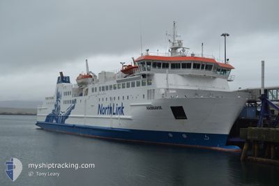
HAMNAVOE
Ro-Ro/Passenger Ship
Current Trip
| Time Travelled | 1 h, 17 mins |
|---|---|
| Remaining Time | 1 mins |
| Distance Travelled | 21.65 nm |
| Remaining Distance | 5.18 nm |
| AVG Speed | 18.9 Noeuds |
| MAX Speed | 19.9 Noeuds |
| AVG Wind | 17.6 knots |
| MAX Wind | 18.2 knots |
| MIN Temp | 9.7°C / 49.46°F |
| MAX Temp | 10.3°C / 50.54°F |
| Tirant d eau | 4.5 m |
| Position reçue | 1 m depuis |
Current Position
| Longitude | -3.52409° |
|---|---|
| Latitude | 58.62821° |
| Etat | Under way using engine |
| Vitesse | 19 Noeuds |
| Parcours | 196.7° |
| Zone | North Atlantic Ocean |
| Station | T-AIS |
| Position reçue | 1 m depuis |
Info
Information
The current position of HAMNAVOE is in North Atlantic Ocean with coordinates 58.62821° / -3.52409° as reported on 2024-05-09 11:16 by AIS to our vessel tracker app. The vessel's current speed is 19 Noeuds and is heading at the port of SCRABSTER. The estimated time of arrival as calculated by MyShipTracking vessel tracking app is 2024-05-09 11:19 LT
The vessel HAMNAVOE (IMO: 9246061, MMSI: 235449000) is a Ro-Ro/Passenger Ship that was built in 2002 ( 22 Age ). It's sailing under the flag of [GB] United Kingdom.
In this page you can find informations about the vessels current position, last detected port calls, and current voyage information. If the vessels is not in coverage by AIS you will find the latest position.
The current position of HAMNAVOE is detected by our AIS receivers and we are not responsible for the reliability of the data. The last position was recorded while the vessel was in Coverage by the Ais receivers of our vessel tracking app.
The current draught of HAMNAVOE as reported by AIS is 4.5 meters
Weather
| Temperature | 10.1°C / 50.18°F |
|---|---|
| Wind Speed | 16 knots |
| Direction | 280° W |
| Pressure | 1022.2 hPa |
| Humidity | 95.8 % |
| Cloud Coverage | 100 % |
Featured Company
Last Port Calls
| Port | Arrival | Departure | Time In Port |
|---|---|---|---|
| 2024-05-09 09:03 | 2024-05-09 10:01 | 58 m | |
| 2024-05-09 06:49 | 2024-05-09 07:35 | 46 m | |
| 2024-05-08 19:19 | 2024-05-09 05:25 | 10 h | |
| 2024-05-08 17:06 | 2024-05-08 17:58 | 52 m | |
| 2024-05-08 13:35 | 2024-05-08 15:35 | 2 h | |
| 2024-05-08 11:19 | 2024-05-08 11:59 | 39 m | |
| 2024-05-08 09:06 | 2024-05-08 09:56 | 49 m | |
| 2024-05-08 06:44 | 2024-05-08 07:48 | 1 h | |
| 2024-05-07 19:19 | 2024-05-08 05:21 | 10 h | |
| 2024-05-07 17:02 | 2024-05-07 17:57 | 54 m |
Last Trips
| Origin | Departure | Destination | Arrival | Distance | |
|---|---|---|---|---|---|
| 2024-05-09 08:35 | 2024-05-09 10:03 | 25.01 nm | |||
| 2024-05-09 06:25 | 2024-05-09 07:49 | 24.74 nm | |||
| 2024-05-08 18:58 | 2024-05-08 20:19 | 24.65 nm | |||
| 2024-05-08 16:35 | 2024-05-08 18:06 | 24.67 nm | |||
| 2024-05-08 12:59 | 2024-05-08 14:35 | 24.75 nm | |||
| 2024-05-08 10:56 | 2024-05-08 12:19 | 24.74 nm | |||
| 2024-05-08 08:48 | 2024-05-08 10:06 | 24.33 nm | |||
| 2024-05-08 06:21 | 2024-05-08 07:44 | 24.82 nm | |||
| 2024-05-07 18:57 | 2024-05-07 20:19 | 24.56 nm | |||
| 2024-05-07 16:37 | 2024-05-07 18:02 | 24.66 nm |
Events
| Heure | Evenement | Détails | Position/ Destination | Info |
|---|---|---|---|---|
| 2024-05-09 10:13 | Changement de zone | United Kingdom part of the North Atlantic Ocean United Kingdom part of the North Sea |
58.94182 / -3.37250
North Atlantic Ocean
STROMNESS SCRABSTER
|
Vitesse: 17.8 kn Parcours: 256.6° |
| 2024-05-09 10:01 | PORT DE DEPART |
|
58.95635 / -3.29567
STROMNESS SCRABSTER
|
Vitesse: 8.2 kn Parcours: 170° |
| 2024-05-09 09:58 | Changement d'ETA | 2024/05/09 12:30 2024/05/09 10:15 |
58.95999 / -3.29529
[GB] STROMNESS
|
Vitesse: 1.8 kn Parcours: 125° |
| 2024-05-09 09:57 | Démarrage |
58.96111 / -3.29483
[GB] STROMNESS
|
Vitesse: 3.2 kn Parcours: 39° |
|
| 2024-05-09 09:09 | Arret |
58.96347 / -3.29501
[GB] STROMNESS
|
Vitesse: 0.3 kn Parcours: 355° |
|
| 2024-05-09 09:03 | Port d'arrivée |
|
58.95808 / -3.29611
[GB] STROMNESS
|
Vitesse: 7.3 kn Parcours: 3.5° |
| 2024-05-09 08:52 | Changement de zone | United Kingdom part of the North Sea United Kingdom part of the North Atlantic Ocean |
58.94631 / -3.35399
North Sea
STROMNESS SCRABSTER
|
Vitesse: 19.4 kn Parcours: 84.3° |
| 2024-05-09 07:35 | PORT DE DEPART |
|
58.61126 / -3.53296
STROMNESS SCRABSTER
|
Vitesse: 12.4 kn Parcours: 25° |
| 2024-05-09 07:34 | Démarrage |
58.60923 / -3.53908
[GB] SCRABSTER
|
Vitesse: 6.3 kn Parcours: 120° |
|
| 2024-05-09 07:20 | Etat Changé | Under way using engine Moored |
58.61111 / -3.54031
[GB] SCRABSTER
|
Vitesse: Parcours: 185° |