

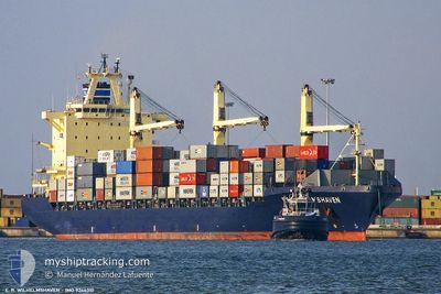
GROTON
Container Ship

Current Trip
| Trip Time | 2 days |
|---|---|
| Trip Distance | 560.52 nm |
| AVG Speed | 9.3 Noeuds |
| MAX Speed | 11.8 Noeuds |
| Tirant d eau | 11.1 m |
| AVG Wind | 8 knots |
| MAX Wind | 14.2 knots |
| MIN Temp | 23.3°C / 73.94°F |
| MAX Temp | 27.2°C / 80.96°F |
| Position reçue | 9 d depuis |
Current Position
| Longitude | --- |
|---|---|
| Latitude | --- |
| Etat | Under way using engine |
| Vitesse | 9.2 Noeuds |
| Parcours | 118.9° |
| Zone | Gulf of Oman |
| Station | T-AIS |
| Position reçue | 9 d depuis |
Information
The current position of GROTON is in Gulf of Oman with coordinates 25.16961° / 57.33338° as reported on 2025-02-19 09:22 by AIS to our vessel tracker app. The vessel's current speed is 9.2 Noeuds and is currently inside the port of KARACHI.
The vessel GROTON (IMO: 9246310, MMSI: 636017309) is a Container Ship that was built in 2002 ( 23 Age ). It's sailing under the flag of [LR] Liberia.
In this page you can find informations about the vessels current position, last detected port calls, and current voyage information. If the vessels is not in coverage by AIS you will find the latest position.
The current position of GROTON is detected by our AIS receivers and we are not responsible for the reliability of the data. The last position was recorded while the vessel was in Coverage by the Ais receivers of our vessel tracking app.
The current draught of GROTON as reported by AIS is 11.1 meters
Weather
| Temperature | 23.6°C / 74.48°F |
|---|---|
| Wind Speed | 16 knots |
| Direction | 253° WSW |
| Pressure | 1010.7 hPa |
| Humidity | 76.2 % |
| Cloud Coverage | 100 % |


Featured Company
Last Port Calls
| Port | Arrival | Departure | Time In Port |
|---|---|---|---|
| 2025-02-28 07:17 | |||
| 2025-02-25 07:12 | 2025-02-25 18:45 | 11 h | |
| 2025-02-22 22:49 | 2025-02-23 15:49 | 16 h | |
| 2025-02-16 21:46 | 2025-02-18 10:34 | 1 d | |
| 2025-02-13 12:10 | 2025-02-14 07:04 | 18 h | |
| 2025-02-10 10:25 | 2025-02-11 20:45 | 1 d | |
| 2025-02-08 14:49 | 2025-02-08 20:44 | 5 h | |
| 2025-02-07 05:42 | 2025-02-07 16:08 | 10 h | |
| 2025-02-05 21:15 | 2025-02-06 12:02 | 14 h | |
| 2025-02-03 03:58 | 2025-02-03 19:07 | 15 h |
Last Trips
| Origin | Departure | Destination | Arrival | Distance | |
|---|---|---|---|---|---|
| 2025-02-26 00:15 | 2025-02-28 12:17 | 560.52 nm | |||
| 2025-02-23 21:19 | 2025-02-25 12:42 | 432.12 nm | |||
| 2025-02-18 14:34 | 2025-02-23 04:19 | 961.61 nm | |||
| 2025-02-14 10:04 | 2025-02-17 01:46 | 494.92 nm | |||
| 2025-02-11 23:45 | 2025-02-13 15:10 | 142.18 nm | |||
| 2025-02-08 23:44 | 2025-02-10 13:25 | 318.35 nm | |||
| 2025-02-07 20:08 | 2025-02-08 17:49 | 300.79 nm | |||
| 2025-02-06 16:02 | 2025-02-07 09:42 | 38.79 nm | |||
| 2025-02-03 22:07 | 2025-02-06 01:15 | 298.10 nm | |||
| 2025-02-01 15:43 | 2025-02-03 06:58 | 532.99 nm |
Events
| Heure | Evenement | Détails | Position/ Destination | Info |
|---|---|---|---|---|
| 2025-02-28 07:17 | Arret |
24.82632 / 66.97497
[PK] KARACHI
|
Vitesse: Parcours: 27° |
|
| 2025-02-28 07:17 | Port d'arrivée |
|
24.82632 / 66.97497
[PK] KARACHI
|
Vitesse: 0.6 kn Parcours: 29° |
| 2025-02-25 18:45 | PORT DE DEPART |
|
18.94612 / 72.93439
INMUN
|
Vitesse: 6.5 kn Parcours: 220° |
| 2025-02-25 18:42 | Démarrage |
18.95231 / 72.94050
[IN] NHAVA SHEVA
|
Vitesse: 6.5 kn Parcours: 220° |
|
| 2025-02-25 07:12 | Arret |
18.95568 / 72.94655
[IN] NHAVA SHEVA
|
Vitesse: Parcours: 22° |
|
| 2025-02-25 07:12 | Port d'arrivée |
|
18.95568 / 72.94655
[IN] NHAVA SHEVA
|
Vitesse: 2.8 kn Parcours: 30° |
| 2025-02-25 03:42 | Démarrage | 18.1 nm, South West of MUMBAI |
18.78836 / 72.62975
INMUN
|
Vitesse: 3.6 kn Parcours: 26° |
| 2025-02-25 02:26 | Arret | 18.41 nm, South West of MUMBAI |
18.78280 / 72.62766
INMUN
|
Vitesse: 0.2 kn Parcours: 351° |
| 2025-02-23 15:49 | PORT DE DEPART |
|
22.71939 / 69.69694
INMUN
|
Vitesse: 3.1 kn Parcours: 177° |
| 2025-02-23 15:30 | Démarrage |
22.73507 / 69.69093
[IN] MUNDRA
|
Vitesse: 3.1 kn Parcours: 280° |