
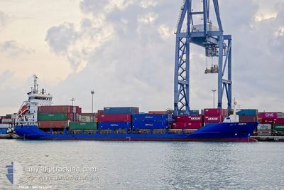
GRETA
Container Ship
Current Trip
MT MAR
| Time Travelled | 12 h, 36 mins |
|---|---|
| Remaining Time | --- |
| Distance Travelled | 119.22 nm |
| Remaining Distance | --- |
| AVG Speed | 9.4 Noeuds |
| MAX Speed | 10.6 Noeuds |
| AVG Wind | 11.5 knots |
| MAX Wind | 17 knots |
| MIN Temp | 19.1°C / 66.38°F |
| MAX Temp | 19.8°C / 67.64°F |
| Tirant d eau | 5.4 m |
| Position reçue | 1 d depuis |
Current Position
| Longitude | 14.85808° |
|---|---|
| Latitude | 35.88698° |
| Etat | At anchor |
| Vitesse | 0.1 Noeuds |
| Parcours | 54° |
| Zone | Mediterranean Sea - Eastern Basin |
| Station | T-AIS |
| Position reçue | 1 d depuis |
Info
Information
The current position of GRETA is in Mediterranean Sea - Eastern Basin with coordinates 35.88698° / 14.85808° as reported on 2024-05-19 06:53 by AIS to our vessel tracker app. The vessel's current speed is 0.1 Noeuds
The vessel GRETA (IMO: 9234422, MMSI: 312479000) is a Container Ship that was built in 2001 ( 23 Age ). It's sailing under the flag of [BZ] Belize.
In this page you can find informations about the vessels current position, last detected port calls, and current voyage information. If the vessels is not in coverage by AIS you will find the latest position.
The current position of GRETA is detected by our AIS receivers and we are not responsible for the reliability of the data. The last position was recorded while the vessel was in Coverage by the Ais receivers of our vessel tracking app.
The current draught of GRETA as reported by AIS is 5.4 meters
Weather
| Temperature | 19.6°C / 67.28°F |
|---|---|
| Wind Speed | 9 knots |
| Direction | 98° E |
| Pressure | 1006.3 hPa |
| Humidity | 91.9 % |
| Cloud Coverage | 6 % |
Featured Company
Last Port Calls
| Port | Arrival | Departure | Time In Port |
|---|---|---|---|
| 2024-05-19 12:28 | 2024-05-19 20:40 | 8 h | |
| 2024-05-16 12:49 | 2024-05-16 17:41 | 4 h | |
| 2024-05-15 08:37 | 2024-05-15 13:33 | 4 h | |
| 2024-05-13 22:14 | 2024-05-14 08:09 | 9 h | |
| 2024-05-11 17:59 | 2024-05-12 02:49 | 8 h | |
| 2024-05-11 02:39 | 2024-05-11 12:58 | 10 h | |
| 2024-05-10 15:16 | 2024-05-10 19:49 | 4 h | |
| 2024-05-06 17:09 | 2024-05-07 14:25 | 21 h | |
| 2024-04-29 17:08 | 2024-04-29 23:50 | 6 h | |
| 2024-04-29 02:20 | 2024-04-29 09:36 | 7 h |
Most Visited Ports (Last year)
| Port | Arrivals | |
|---|---|---|
| 21 | ||
| 18 | ||
| 16 | ||
| 15 | ||
| 15 | ||
| 14 |
Last Trips
| Origin | Departure | Destination | Arrival | Distance | |
|---|---|---|---|---|---|
| 2024-05-16 17:41 | 2024-05-19 12:28 | 533.91 nm | |||
| 2024-05-15 13:33 | 2024-05-16 12:49 | 194.32 nm | |||
| 2024-05-14 08:09 | 2024-05-15 08:37 | 256.97 nm | |||
| 2024-05-12 02:49 | 2024-05-13 22:14 | 10.26 nm | |||
| 2024-05-11 12:58 | 2024-05-11 17:59 | 47.23 nm | |||
| 2024-05-10 19:49 | 2024-05-11 02:39 | 59.88 nm | |||
| 2024-05-07 14:25 | 2024-05-10 15:16 | 559.00 nm | |||
| 2024-04-29 23:50 | 2024-05-06 17:09 | 655.29 nm | |||
| 2024-04-29 09:36 | 2024-04-29 17:08 | 57.31 nm | |||
| 2024-04-27 16:12 | 2024-04-29 02:20 | 299.91 nm |
Events
| Heure | Evenement | Détails | Position/ Destination | Info |
|---|---|---|---|---|
| 2024-05-19 18:40 | PORT DE DEPART |
|
35.79833 / 14.57167
MT MAR
|
Vitesse: 7.6 kn Parcours: 129° |
| 2024-05-19 18:22 | Démarrage |
35.82457 / 14.54084
[MT] MARSAXLOKK
|
Vitesse: 5.1 kn Parcours: 80° |
|
| 2024-05-19 10:43 | Arret |
35.81667 / 14.54167
[MT] MARSAXLOKK
|
Vitesse: Parcours: -1° |
|
| 2024-05-19 10:28 | Port d'arrivée |
|
35.82333 / 14.54667
[MT] MARSAXLOKK
|
Vitesse: 10.7 kn Parcours: 270° |
| 2024-05-19 09:00 | Tirant d'eau modifié | 5.4 5.2 |
35.81333 / 14.69333
MT MAR
|
Vitesse: 1 kn Parcours: -1° |
| 2024-05-19 09:00 | Changement de destination | MT MAR GP PIR |
35.81333 / 14.69333
MT MAR
|
Vitesse: 1 kn Parcours: -1° |
| 2024-05-19 09:00 | Changement d'ETA | 2024/05/18 18:00 2024/05/16 08:00 |
35.81333 / 14.69333
MT MAR
|
Vitesse: 1 kn Parcours: -1° |
| 2024-05-19 07:05 | Démarrage | 15.53 nm, East of MARSAXLOKK |
35.88318 / 14.85684
GP PIR
|
Vitesse: 6.1 kn Parcours: 215° |
| 2024-05-19 06:56 | Etat Changé | Default At anchor |
35.88708 / 14.85812
GP PIR
|
Vitesse: 0.1 kn Parcours: 54° |
| 2024-05-19 06:53 | Hors de la zone couverte |
35.88698 / 14.85808
Mediterranean Sea - Eastern Basin
|
Vitesse: 0.1 kn Parcours: 233.3° |