
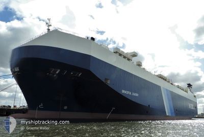
GRACEFUL LEADER
Vehicles Carrier
Current Trip
| Time Travelled | 20 h, 20 mins |
|---|---|
| Remaining Time | --- |
| Distance Travelled | 307.39 nm |
| Remaining Distance | --- |
| AVG Speed | 14.7 Noeuds |
| MAX Speed | 19.3 Noeuds |
| AVG Wind | 15.6 knots |
| MAX Wind | 20 knots |
| MIN Temp | -1.1°C / 30.02°F |
| MAX Temp | 11.1°C / 51.98°F |
| Tirant d eau | 8.6 m |
| Position reçue | 13 h, 39 m depuis |
Current Position
| Longitude | --- |
|---|---|
| Latitude | --- |
| Etat | Under way using engine |
| Vitesse | 16.7 Noeuds |
| Parcours | 181.9° |
| Zone | North Atlantic Ocean |
| Station | T-AIS |
| Position reçue | 13 h, 39 m depuis |
Info
Information
The current position of GRACEFUL LEADER is in North Atlantic Ocean with coordinates 39.16366° / -73.91391° as reported on 2026-01-03 07:14 by AIS to our vessel tracker app. The vessel's current speed is 16.7 Noeuds and is heading at the port of JACKSONVILLE. The estimated time of arrival as calculated by MyShipTracking vessel tracking app is 2026-01-05 00:01 LT
The vessel GRACEFUL LEADER (IMO: 9357303, MMSI: 309253000) is a Vehicles Carrier that was built in 2007 ( 19 Age ). It's sailing under the flag of [BS] Bahamas.
In this page you can find informations about the vessels current position, last detected port calls, and current voyage information. If the vessels is not in coverage by AIS you will find the latest position.
The current position of GRACEFUL LEADER is detected by our AIS receivers and we are not responsible for the reliability of the data. The last position was recorded while the vessel was in Coverage by the Ais receivers of our vessel tracking app.
The current draught of GRACEFUL LEADER as reported by AIS is 8.6 meters
Weather
| Temperature | 11.2°C / 52.16°F |
|---|---|
| Wind Speed | 18 knots |
| Direction | 38° NE |
| Pressure | 1012.5 hPa |
| Humidity | 85.7 % |
| Cloud Coverage | 100 % |
Featured Company
Last Port Calls
| Port | Arrival | Departure | Time In Port |
|---|---|---|---|
| 2026-01-02 03:17 | 2026-01-02 19:34 | 16 h | |
| 2025-12-28 19:39 | 2025-12-30 22:16 | 2 d | |
| 2025-12-26 05:10 | 2025-12-26 17:29 | 12 h | |
| 2025-12-24 05:09 | 2025-12-24 16:53 | 11 h | |
| 2025-12-20 22:08 | 2025-12-21 13:52 | 15 h | |
| 2025-11-23 06:13 | 2025-11-24 14:17 | 1 d | |
| 2025-11-22 06:53 | 2025-11-22 16:59 | 10 h | |
| 2025-11-20 06:29 | 2025-11-21 14:20 | 1 d | |
| 2025-11-19 06:52 | 2025-11-19 17:12 | 10 h | |
| 2025-11-15 08:09 | 2025-11-15 13:37 | 5 h |
Most Visited Ports (Last year)
| Port | Arrivals | |
|---|---|---|
| 3 | ||
| 2 | ||
| 2 | ||
| 2 | ||
| 2 | ||
| 2 |
Last Trips
| Origin | Departure | Destination | Arrival | Distance | |
|---|---|---|---|---|---|
| 2025-12-30 22:16 | 2026-01-02 03:17 | 353.05 nm | |||
| 2025-12-26 17:29 | 2025-12-28 19:39 | 410.75 nm | |||
| 2025-12-24 16:53 | 2025-12-26 05:10 | 326.72 nm | |||
| 2025-12-21 13:52 | 2025-12-24 05:09 | 1018.30 nm | |||
| 2025-11-24 14:17 | 2025-12-20 22:08 | 10006.15 nm | |||
| 2025-11-22 16:59 | 2025-11-23 06:13 | 165.85 nm | |||
| 2025-11-21 14:20 | 2025-11-22 06:53 | 200.93 nm | |||
| 2025-11-19 17:12 | 2025-11-20 06:29 | 114.87 nm | |||
| 2025-11-15 13:37 | 2025-11-19 06:52 | 1072.20 nm | |||
| 2025-11-10 01:28 | 2025-11-15 08:09 | 1997.66 nm |
Events
| Heure | Evenement | Détails | Position/ Destination | Info |
|---|---|---|---|---|
| 2026-01-03 07:20 | Etat Changé | Default Under way using engine |
39.13500 / -73.91500
US JAX
|
Vitesse: 16.7 kn Parcours: 181.9° |
| 2026-01-03 07:14 | Etat Changé | Under way using engine Default |
39.16366 / -73.91391
US JAX
|
Vitesse: 16.7 kn Parcours: 182° |
| 2026-01-03 07:14 | Hors de la zone couverte |
39.16366 / -73.91391
North Atlantic Ocean
US JAX
|
Vitesse: 16.7 kn Parcours: 181.9° |
|
| 2026-01-03 06:58 | Dans la zone couverte |
39.16366 / -73.91391
North Atlantic Ocean
US JAX
|
Vitesse: 16.7 kn Parcours: 181.9° |
|
| 2026-01-03 06:15 | Etat Changé | Default Under way using engine |
39.44271 / -73.89167
US JAX
|
Vitesse: 16.9 kn Parcours: 184.3° |
| 2026-01-03 06:07 | Hors de la zone couverte |
39.47891 / -73.88836
North Atlantic Ocean
US JAX
|
Vitesse: 16.9 kn Parcours: 184.3° |
|
| 2026-01-03 00:34 | PORT DE DEPART |
|
40.57658 / -74.03557
US JAX
|
Vitesse: 13.3 kn Parcours: 168° |
| 2026-01-03 00:08 | Etat Changé | Under way using engine Default |
40.65038 / -74.07775
[US] NEW YORK
|
Vitesse: 9.1 kn Parcours: 83° |
| 2026-01-03 00:07 | Etat Changé | Default Under way using engine |
40.65059 / -74.08397
[US] NEW YORK
|
Vitesse: 7.5 kn Parcours: 80° |
| 2026-01-02 23:32 | Changement de destination | US JAX US NYK |
40.64840 / -74.15146
[US] NEW YORK
|
Vitesse: 8.4 kn Parcours: 204° |