

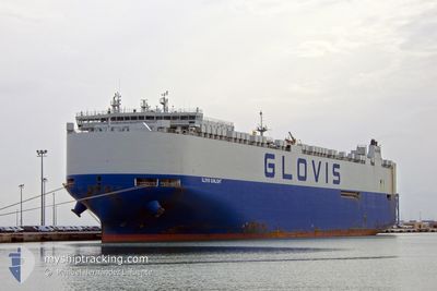
GLOVIS SUNLIGHT
Cargo

Current Trip
| Time Travelled | 15 days |
|---|---|
| Remaining Time | --- |
| Distance Travelled | 6430.92 nm |
| Remaining Distance | --- |
| AVG Speed | 17.4 Noeuds |
| MAX Speed | 20.2 Noeuds |
| AVG Wind | 9.9 knots |
| MAX Wind | 24.9 knots |
| MIN Temp | -3.6°C / 25.52°F |
| MAX Temp | 29.1°C / 84.38°F |
| Tirant d eau | 9.8 m |
| Position reçue | 8 d depuis |
Current Position
| Longitude | --- |
|---|---|
| Latitude | --- |
| Etat | Under way using engine |
| Vitesse | 19.2 Noeuds |
| Parcours | 281.6° |
| Zone | Singapore Strait |
| Station | T-AIS |
| Position reçue | 8 d depuis |
Information
The current position of GLOVIS SUNLIGHT is in Singapore Strait with coordinates 1.19728° / 103.56967° as reported on 2025-02-15 23:56 by AIS to our vessel tracker app. The vessel's current speed is 19.2 Noeuds and is heading at the port of SETUBAL. The estimated time of arrival as calculated by MyShipTracking vessel tracking app is 2025-03-13 07:00 LT
The vessel GLOVIS SUNLIGHT (IMO: 9798416, MMSI: 538007440) is a Cargo It's sailing under the flag of [MH] Marshall Is.
In this page you can find informations about the vessels current position, last detected port calls, and current voyage information. If the vessels is not in coverage by AIS you will find the latest position.
The current position of GLOVIS SUNLIGHT is detected by our AIS receivers and we are not responsible for the reliability of the data. The last position was recorded while the vessel was in Coverage by the Ais receivers of our vessel tracking app.
The current draught of GLOVIS SUNLIGHT as reported by AIS is 9.8 meters
Weather
| Temperature | 27.6°C / 81.68°F |
|---|---|
| Wind Speed | 20 knots |
| Direction | 86° E |
| Pressure | 1011.9 hPa |
| Humidity | 81.7 % |
| Cloud Coverage | 76 % |


Featured Company
Last Port Calls
| Port | Arrival | Departure | Time In Port |
|---|---|---|---|
| 2025-02-08 09:25 | 2025-02-09 01:41 | 16 h | |
| 2025-02-02 04:56 | 2025-02-04 03:07 | 1 d | |
| 2025-01-30 18:00 | 2025-01-31 06:16 | 12 h | |
| 2025-01-26 21:31 | 2025-01-27 10:53 | 13 h | |
| 2025-01-24 22:42 | 2025-01-26 09:35 | 1 d | |
| 2025-01-24 16:37 | 2025-01-24 16:55 | 17 m | |
| 2025-01-23 21:14 | 2025-01-24 09:25 | 12 h | |
| 2025-01-22 22:19 | 2025-01-23 12:50 | 14 h | |
| 2024-12-27 21:22 | 2024-12-28 10:26 | 13 h | |
| 2024-12-24 06:04 | 2024-12-24 16:46 | 10 h |
Most Visited Ports (Last year)
| Port | Arrivals | |
|---|---|---|
| 6 | ||
| 4 | ||
| 4 | ||
| 4 | ||
| 3 | ||
| 3 |
Last Trips
| Origin | Departure | Destination | Arrival | Distance | |
|---|---|---|---|---|---|
| 2025-02-04 12:07 | 2025-02-08 17:25 | 806.46 nm | |||
| 2025-01-31 15:16 | 2025-02-02 13:56 | 171.30 nm | |||
| 2025-01-27 19:53 | 2025-01-31 03:00 | 485.23 nm | |||
| 2025-01-26 18:35 | 2025-01-27 06:31 | 170.75 nm | |||
| 2025-01-25 01:55 | 2025-01-25 07:42 | 65.51 nm | |||
| 2025-01-24 18:25 | 2025-01-25 01:37 | 106.98 nm | |||
| 2025-01-23 21:50 | 2025-01-24 06:14 | 128.20 nm | |||
| 2024-12-28 05:26 | 2025-01-23 07:19 | 9591.56 nm | |||
| 2024-12-24 11:46 | 2024-12-27 16:22 | 1347.16 nm | |||
| 2024-12-22 00:19 | 2024-12-24 01:04 | 759.55 nm |
Events
| Heure | Evenement | Détails | Position/ Destination | Info |
|---|---|---|---|---|
| 2025-02-16 00:01 | Etat Changé | Default Under way using engine |
1.20279 / 103.54244
PTSET
|
Vitesse: 19.2 kn Parcours: 281.6° |
| 2025-02-15 23:56 | Hors de la zone couverte |
1.19728 / 103.56967
Singapore Strait
PTSET
|
Vitesse: 19.2 kn Parcours: 281.6° |
|
| 2025-02-15 23:53 | Changement de zone | Malaysian part of the Singapore Strait Indonesian part of the Singapore Strait |
1.19396 / 103.58600
Singapore Strait
PTSET
|
Vitesse: 19.2 kn Parcours: 281.5° |
| 2025-02-15 23:25 | Changement de zone | Indonesian part of the Singapore Strait Singaporean part of the Singapore Strait |
1.14317 / 103.72226
Singapore Strait
PTSET
|
Vitesse: 17.2 kn Parcours: 298.7° |
| 2025-02-15 22:29 | Tirant d'eau modifié | 9.8 9.2 |
1.24953 / 103.96305
PTSET
|
Vitesse: 15.2 kn Parcours: 242.7° |
| 2025-02-15 22:29 | Changement de destination | PTSET SGSIN PEBGC |
1.24953 / 103.96305
PTSET
|
Vitesse: 15.2 kn Parcours: 242.7° |
| 2025-02-15 22:29 | Changement d'ETA | 2025/03/13 07:00 2025/02/15 06:15 |
1.24953 / 103.96305
PTSET
|
Vitesse: 15.2 kn Parcours: 242.7° |
| 2025-02-15 22:28 | Etat Changé | Under way using engine At anchor |
1.25127 / 103.96631
SGSIN PEBGC
|
Vitesse: 14.7 kn Parcours: 239° |
| 2025-02-15 22:10 | Démarrage | 2.47 nm, South West of TANAH MERAH |
1.28251 / 103.98926
SGSIN PEBGC
|
Vitesse: 4.8 kn Parcours: 148° |
| 2025-02-15 21:51 | Etat Changé | At anchor Default |
1.28488 / 103.98590
SGSIN PEBGC
|
Vitesse: 0.2 kn Parcours: 37° |