

GLOBAL DISCOVERY
Cargo

Current Trip
US-LOG > HIRO-JPN
| Time Travelled | 12 h, 43 mins |
|---|---|
| Remaining Time | --- |
| Distance Travelled | 121.08 nm |
| Remaining Distance | --- |
| AVG Speed | 13 Noeuds |
| MAX Speed | 15.3 Noeuds |
| AVG Wind | 18.2 knots |
| MAX Wind | 25 knots |
| MIN Temp | 6.4°C / 43.52°F |
| MAX Temp | 10°C / 50°F |
| Tirant d eau | 10.9 m |
| Position reçue | 9 d depuis |
Current Position
| Longitude | --- |
|---|---|
| Latitude | --- |
| Etat | Under way using engine |
| Vitesse | 12.1 Noeuds |
| Parcours | 249° |
| Zone | North Pacific Ocean |
| Station | T-AIS |
| Position reçue | 9 d depuis |
Information
The current position of GLOBAL DISCOVERY is in North Pacific Ocean with coordinates 34.71831° / 139.74404° as reported on 2025-03-08 21:44 by AIS to our vessel tracker app. The vessel's current speed is 12.1 Noeuds
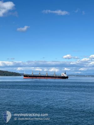
The vessel GLOBAL DISCOVERY (IMO: 9725691, MMSI: 577332000) is a Cargo It's sailing under the flag of [VU] Vanuatu.
In this page you can find informations about the vessels current position, last detected port calls, and current voyage information. If the vessels is not in coverage by AIS you will find the latest position.
The current position of GLOBAL DISCOVERY is detected by our AIS receivers and we are not responsible for the reliability of the data. The last position was recorded while the vessel was in Coverage by the Ais receivers of our vessel tracking app.
The current draught of GLOBAL DISCOVERY as reported by AIS is 10.9 meters
Weather
| Temperature | 8.8°C / 47.84°F |
|---|---|
| Wind Speed | 26 knots |
| Direction | 294° WNW |
| Pressure | 1015.8 hPa |
| Humidity | 59.4 % |
| Cloud Coverage | 28 % |


Featured Company
Last Port Calls
| Port | Arrival | Departure | Time In Port |
|---|---|---|---|
| 2025-03-12 10:13 | 2025-03-18 08:50 | 5 d | |
| 2025-03-12 03:27 | 2025-03-12 06:09 | 2 h | |
| 2025-03-11 14:33 | 2025-03-11 20:27 | 5 h | |
| 2025-02-15 04:31 | 2025-02-19 14:02 | 4 d | |
| 2025-01-22 16:13 | 2025-01-28 10:05 | 5 d | |
| 2025-01-22 12:59 | 2025-01-22 15:33 | 2 h | |
| 2025-01-21 12:41 | 2025-01-21 19:20 | 6 h | |
| 2025-01-20 12:53 | 2025-01-20 19:17 | 6 h | |
| 2025-01-19 19:41 | 2025-01-19 20:17 | 36 m | |
| 2025-01-18 18:17 | 2025-01-18 18:59 | 42 m |
Last Trips
| Origin | Departure | Destination | Arrival | Distance | |
|---|---|---|---|---|---|
| 2025-03-12 06:09 | 2025-03-12 10:13 | 2.06 nm | |||
| 2025-03-11 20:27 | 2025-03-12 03:27 | 0.39 nm | |||
| 2025-02-19 14:02 | 2025-03-11 14:33 | 5053.77 nm | |||
| 2025-01-28 10:05 | 2025-02-15 04:31 | 4856.95 nm | |||
| 2025-01-22 15:33 | 2025-01-22 16:13 | 1.69 nm | |||
| 2025-01-21 19:20 | 2025-01-22 12:59 | 1.24 nm | |||
| 2025-01-20 19:17 | 2025-01-21 12:41 | 0.98 nm | |||
| 2025-01-19 20:17 | 2025-01-20 12:53 | 0.95 nm | |||
| 2025-01-18 18:59 | 2025-01-19 19:41 | 1.71 nm | |||
| 2024-12-04 10:04 | 2025-01-18 18:17 | 9932.19 nm |
Events
| Heure | Evenement | Détails | Position/ Destination | Info |
|---|---|---|---|---|
| 2025-03-17 23:50 | PORT DE DEPART |
|
34.19400 / 132.60356
US-LOG > HIRO-JPN
|
Vitesse: 9.6 kn Parcours: 207° |
| 2025-03-17 23:38 | Démarrage |
34.21863 / 132.61130
[JP] KURE
|
Vitesse: 4.4 kn Parcours: 209° |
|
| 2025-03-12 01:14 | Arret |
34.22325 / 132.61371
[JP] KURE
|
Vitesse: 0.2 kn Parcours: 29° |
|
| 2025-03-12 01:13 | Port d'arrivée |
|
34.22325 / 132.61371
[JP] KURE
|
Vitesse: 1.5 kn Parcours: 26° |
| 2025-03-12 00:38 | Démarrage | 2.94 nm, West of NIGATA |
34.20074 / 132.60565
US-LOG > HIRO-JPN
|
Vitesse: 4.1 kn Parcours: 316° |
| 2025-03-11 21:09 | PORT DE DEPART |
|
34.20248 / 132.61429
US-LOG > HIRO-JPN
|
Vitesse: Parcours: 300° |
| 2025-03-11 18:27 | Port d'arrivée |
|
34.20398 / 132.61189
[JP] KURE
|
Vitesse: 0.2 kn Parcours: 137° |
| 2025-03-11 11:27 | PORT DE DEPART |
|
34.20247 / 132.61449
US-LOG > HIRO-JPN
|
Vitesse: 0.2 kn Parcours: 280° |
| 2025-03-11 05:33 | Port d'arrivée |
|
34.20412 / 132.61066
[JP] KURE
|
Vitesse: Parcours: 130° |
| 2025-03-11 04:34 | Arret | 2.67 nm, West of NIGATA |
34.20211 / 132.61099
US-LOG > HIRO-JPN
|
Vitesse: 0.3 kn Parcours: 55° |