
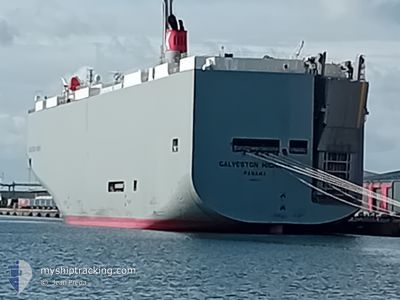
GALVESTON HIGHWAY
Cargo
Current Trip
| Trip Time | 8 days |
|---|---|
| Trip Distance | 3220.48 nm |
| AVG Speed | 16 Noeuds |
| MAX Speed | 18.4 Noeuds |
| Tirant d eau | 9 m |
| AVG Wind | 13.3 knots |
| MAX Wind | 20.9 knots |
| MIN Temp | 19.3°C / 66.74°F |
| MAX Temp | 26.4°C / 79.52°F |
| Position reçue | 1 d depuis |
Current Position
| Longitude | --- |
|---|---|
| Latitude | --- |
| Etat | Under way using engine |
| Vitesse | 11.4 Noeuds |
| Parcours | 78° |
| Zone | North Pacific Ocean |
| Station | T-AIS |
| Position reçue | 1 d depuis |
Info
Information
The current position of GALVESTON HIGHWAY is in North Pacific Ocean with coordinates 17.71968° / -102.74665° as reported on 2025-02-17 07:09 by AIS to our vessel tracker app. The vessel's current speed is 11.4 Noeuds and is currently inside the port of LAZARO CARDENAS.
The vessel GALVESTON HIGHWAY (MMSI: 353100000) is a Cargo It's sailing under the flag of [PA] Panama.
In this page you can find informations about the vessels current position, last detected port calls, and current voyage information. If the vessels is not in coverage by AIS you will find the latest position.
The current position of GALVESTON HIGHWAY is detected by our AIS receivers and we are not responsible for the reliability of the data. The last position was recorded while the vessel was in Coverage by the Ais receivers of our vessel tracking app.
The current draught of GALVESTON HIGHWAY as reported by AIS is 9 meters
Weather
| Temperature | 26.9°C / 80.42°F |
|---|---|
| Wind Speed | 1 knots |
| Direction | 143° SE |
| Pressure | 1013.9 hPa |
| Humidity | 58.7 % |
| Cloud Coverage | 94 % |
Featured Company
Last Port Calls
| Port | Arrival | Departure | Time In Port |
|---|---|---|---|
| 2025-02-17 06:03 | |||
| 2025-02-08 04:15 | 2025-02-08 19:02 | 14 h | |
| 2025-01-30 06:17 | 2025-01-30 17:48 | 11 h | |
| 2025-01-29 05:51 | 2025-01-29 17:40 | 11 h | |
| 2025-01-25 12:41 | 2025-01-25 21:37 | 8 h | |
| 2025-01-25 06:05 | 2025-01-25 08:57 | 2 h | |
| 2025-01-22 06:33 | 2025-01-22 18:22 | 11 h | |
| 2025-01-13 19:51 | 2025-01-14 04:24 | 8 h | |
| 2025-01-09 06:16 | 2025-01-09 14:49 | 8 h | |
| 2025-01-02 15:37 | 2025-01-03 07:35 | 15 h |
Last Trips
| Origin | Departure | Destination | Arrival | Distance | |
|---|---|---|---|---|---|
| 2025-02-08 19:02 | 2025-02-17 06:03 | 3220.48 nm | |||
| 2025-01-30 17:48 | 2025-02-08 04:15 | 3540.93 nm | |||
| 2025-01-29 17:40 | 2025-01-30 06:17 | 199.30 nm | |||
| 2025-01-25 21:37 | 2025-01-29 05:51 | 1005.39 nm | |||
| 2025-01-25 08:57 | 2025-01-25 12:41 | 32.24 nm | |||
| 2025-01-22 18:22 | 2025-01-25 06:05 | 907.34 nm | |||
| 2025-01-14 04:24 | 2025-01-22 06:33 | 3244.61 nm | |||
| 2025-01-09 14:49 | 2025-01-13 19:51 | 1306.07 nm | |||
| 2025-01-03 07:35 | 2025-01-09 06:16 | 938.73 nm | |||
| 2024-12-27 16:54 | 2025-01-02 15:37 | 1554.34 nm |
Events
| Heure | Evenement | Détails | Position/ Destination | Info |
|---|---|---|---|---|
| 2025-02-17 12:42 | Arret |
17.94892 / -102.17227
[MX] LAZARO CARDENAS
|
Vitesse: Parcours: 205° |
|
| 2025-02-17 12:03 | Port d'arrivée |
|
17.93288 / -102.17619
[MX] LAZARO CARDENAS
|
Vitesse: 7.9 kn Parcours: 314° |
| 2025-02-17 11:40 | Démarrage | 2.9 nm, South East of LAZARO CARDENAS |
17.89717 / -102.14562
US HNL>MX LZC
|
Vitesse: 5.5 kn Parcours: 352° |
| 2025-02-17 11:23 | Arret | 3.22 nm, South East of LAZARO CARDENAS |
17.89028 / -102.14545
US HNL>MX LZC
|
Vitesse: 0.3 kn Parcours: 359° |
| 2025-02-17 07:13 | Etat Changé | Default Under way using engine |
17.72215 / -102.73394
US HNL>MX LZC
|
Vitesse: 11.4 kn Parcours: 78° |
| 2025-02-17 07:09 | Etat Changé | Under way using engine Default |
17.71968 / -102.74665
US HNL>MX LZC
|
Vitesse: 11.5 kn Parcours: 78° |
| 2025-02-17 07:09 | Hors de la zone couverte |
17.71968 / -102.74665
North Pacific Ocean
|
Vitesse: 11.4 kn Parcours: 78° |
|
| 2025-02-17 06:58 | Etat Changé | Default Under way using engine |
17.71205 / -102.78362
US HNL>MX LZC
|
Vitesse: 11.2 kn Parcours: 79° |
| 2025-02-17 06:24 | Etat Changé | Under way using engine Default |
17.68844 / -102.89173
US HNL>MX LZC
|
Vitesse: 11.3 kn Parcours: 78° |
| 2025-02-17 06:20 | Etat Changé | Default Under way using engine |
17.68533 / -102.90556
US HNL>MX LZC
|
Vitesse: 11.1 kn Parcours: 75° |