
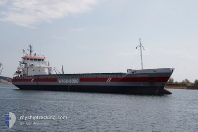
GAASTBORG
General Cargo
Current Trip
| Time Travelled | 2 days |
|---|---|
| Remaining Time | 1 day |
| Distance Travelled | 678.45 nm |
| Remaining Distance | 398.91 nm |
| AVG Speed | 8.9 Noeuds |
| MAX Speed | 14.1 Noeuds |
| AVG Wind | 10 knots |
| MAX Wind | 16 knots |
| MIN Temp | 12.4°C / 54.32°F |
| MAX Temp | 19.5°C / 67.1°F |
| Tirant d eau | 5.8 m |
| Position reçue | Maintenant |
Current Position
| Longitude | -4.85297° |
|---|---|
| Latitude | 49.24925° |
| Etat | Under way using engine |
| Vitesse | 8.9 Noeuds |
| Parcours | 238.1° |
| Zone | English Channel |
| Station | T-AIS |
| Position reçue | Maintenant |
Info
Information
The current position of GAASTBORG is in English Channel with coordinates 49.24925° / -4.85297° as reported on 2024-07-01 13:17 by AIS to our vessel tracker app. The vessel's current speed is 8.9 Noeuds and is heading at the port of PASAJES. The estimated time of arrival as calculated by MyShipTracking vessel tracking app is 2024-07-03 08:01 LT
The vessel GAASTBORG (IMO: 9518268, MMSI: 246845000) is a General Cargo that was built in 2012 ( 12 Age ). It's sailing under the flag of [NL] Netherlands.
In this page you can find informations about the vessels current position, last detected port calls, and current voyage information. If the vessels is not in coverage by AIS you will find the latest position.
The current position of GAASTBORG is detected by our AIS receivers and we are not responsible for the reliability of the data. The last position was recorded while the vessel was in Coverage by the Ais receivers of our vessel tracking app.
The current draught of GAASTBORG as reported by AIS is 5.8 meters
Weather
| Temperature | 15.9°C / 60.62°F |
|---|---|
| Wind Speed | 15 knots |
| Direction | 302° WNW |
| Pressure | 1022.7 hPa |
| Humidity | 79 % |
| Cloud Coverage | 100 % |
Featured Company
Last Port Calls
| Port | Arrival | Departure | Time In Port |
|---|---|---|---|
| 2024-06-28 12:47 | 2024-06-28 13:53 | 1 h | |
| 2024-06-23 14:02 | 2024-06-26 16:15 | 3 d | |
| 2024-06-12 19:28 | 2024-06-13 15:24 | 19 h | |
| 2024-06-12 00:03 | 2024-06-12 17:42 | 17 h | |
| 2024-06-06 00:30 | 2024-06-06 01:41 | 1 h | |
| 2024-06-05 10:12 | 2024-06-05 23:34 | 13 h | |
| 2024-06-02 13:06 | 2024-06-03 10:51 | 21 h | |
| 2024-05-25 12:05 | 2024-05-30 09:36 | 4 d | |
| 2024-05-23 22:19 | 2024-05-25 11:49 | 1 d | |
| 2024-05-20 11:16 | 2024-05-20 11:19 | 3 m |
Last Trips
| Origin | Departure | Destination | Arrival | Distance | |
|---|---|---|---|---|---|
| 2024-06-26 18:15 | 2024-06-28 14:47 | 437.17 nm | |||
| 2024-06-13 17:24 | 2024-06-23 16:02 | 935.44 nm | |||
| 2024-06-12 19:42 | 2024-06-12 21:28 | 16.25 nm | |||
| 2024-06-06 03:41 | 2024-06-12 02:03 | 106.23 nm | |||
| 2024-06-06 01:34 | 2024-06-06 02:30 | 4.81 nm | |||
| 2024-06-03 12:51 | 2024-06-05 12:12 | 399.70 nm | |||
| 2024-05-30 12:36 | 2024-06-02 15:06 | 770.72 nm | |||
| 2024-05-25 14:49 | 2024-05-25 15:05 | 1.07 nm | |||
| 2024-05-20 13:19 | 2024-05-24 01:19 | 845.21 nm | |||
| 2024-05-18 21:50 | 2024-05-20 13:16 | 360.46 nm |
Events
| Heure | Evenement | Détails | Position/ Destination | Info |
|---|---|---|---|---|
| 2024-07-01 11:42 | Etat Changé | Under way using engine Default |
49.36478 / -4.54509
ESPAS
|
Vitesse: 8.7 kn Parcours: 242° |
| 2024-07-01 11:35 | Etat Changé | Default Under way using engine |
49.37330 / -4.52112
ESPAS
|
Vitesse: 8.8 kn Parcours: 240.6° |
| 2024-07-01 11:21 | Etat Changé | Under way using engine Default |
49.38984 / -4.47564
ESPAS
|
Vitesse: 8.9 kn Parcours: 241° |
| 2024-07-01 11:02 | Etat Changé | Default Under way using engine |
49.41252 / -4.41356
ESPAS
|
Vitesse: 9.2 kn Parcours: 236.8° |
| 2024-07-01 10:37 | Etat Changé | Under way using engine Default |
49.44673 / -4.32664
ESPAS
|
Vitesse: 9.3 kn Parcours: 241° |
| 2024-07-01 10:28 | Etat Changé | Default Under way using engine |
49.45824 / -4.29476
ESPAS
|
Vitesse: 9.4 kn Parcours: 240.7° |
| 2024-07-01 10:23 | Detecté en mer | French part of the English Channel |
49.46431 / -4.27773
English Channel
ESPAS
|
Vitesse: 9.4 kn Parcours: 240.7° |
| 2024-07-01 10:23 | Etat Changé | Under way using engine Default |
49.46431 / -4.27773
ESPAS
|
Vitesse: 9.4 kn Parcours: 241° |
| 2024-07-01 10:15 | Dans la zone couverte |
49.46431 / -4.27773
English Channel
ESPAS
|
Vitesse: 9.4 kn Parcours: 240.7° |
|
| 2024-07-01 09:08 | Hors de la zone couverte |
49.56401 / -4.00646
English Channel
ESPAS
|
Vitesse: 9.9 kn Parcours: 239.9° |