
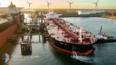
FRONT LOKI
Crude Oil Tanker
Current Trip
FR FOS
| Time Travelled | 1 day |
|---|---|
| Remaining Time | --- |
| Distance Travelled | 11.85 nm |
| Remaining Distance | --- |
| AVG Speed | 5.6 Noeuds |
| MAX Speed | 7.9 Noeuds |
| AVG Wind | 10.8 knots |
| MAX Wind | 19.8 knots |
| MIN Temp | 11°C / 51.8°F |
| MAX Temp | 17.9°C / 64.22°F |
| Tirant d eau | 16.3 m |
| Position reçue | 4 d depuis |
Current Position
| Longitude | 0.20807° |
|---|---|
| Latitude | 38.17972° |
| Etat | Under way using engine |
| Vitesse | 11.9 Noeuds |
| Parcours | 30.7° |
| Zone | Mediterranean Sea - Western Basin |
| Station | T-AIS |
| Position reçue | 4 d depuis |
Info
Information
The current position of FRONT LOKI is in Mediterranean Sea - Western Basin with coordinates 38.17972° / 0.20807° as reported on 2024-04-22 18:11 by AIS to our vessel tracker app. The vessel's current speed is 11.9 Noeuds
The vessel FRONT LOKI (IMO: 9406013, MMSI: 538008947) is a Crude Oil Tanker that was built in 2010 ( 14 Age ). It's sailing under the flag of [MH] Marshall Is.
In this page you can find informations about the vessels current position, last detected port calls, and current voyage information. If the vessels is not in coverage by AIS you will find the latest position.
The current position of FRONT LOKI is detected by our AIS receivers and we are not responsible for the reliability of the data. The last position was recorded while the vessel was in Coverage by the Ais receivers of our vessel tracking app.
The current draught of FRONT LOKI as reported by AIS is 16.3 meters
Weather
| Temperature | 17.2°C / 62.96°F |
|---|---|
| Wind Speed | 18 knots |
| Direction | 126° SE |
| Pressure | 1009 hPa |
| Humidity | 51.1 % |
| Cloud Coverage | 96 % |
Featured Company
Most Visited Ports (Last year)
| Port | Arrivals | |
|---|---|---|
| 1 | ||
| 1 | ||
| 1 | ||
| 1 | ||
| 1 |
Last Trips
| Origin | Departure | Destination | Arrival | Distance |
|---|
Events
| Heure | Evenement | Détails | Position/ Destination | Info |
|---|---|---|---|---|
| 2024-04-25 14:08 | Arret | 1.49 nm, South of PORT DE BOUC |
43.37230 / 4.98047
FR FOS
|
Vitesse: 0.3 kn Parcours: 347° |
| 2024-04-25 13:36 | PORT DE DEPART |
|
43.39190 / 4.93308
FR FOS
|
Vitesse: 9.1 kn Parcours: 109° |
| 2024-04-25 13:20 | Démarrage |
43.40277 / 4.89011
[FR] FOS
|
Vitesse: 4.2 kn Parcours: 131° |
|
| 2024-04-24 16:08 | Arret |
43.40911 / 4.88805
[FR] FOS
|
Vitesse: 0.1 kn Parcours: 331° |
|
| 2024-04-24 15:32 | Port d'arrivée |
|
43.39614 / 4.91610
[FR] FOS
|
Vitesse: 7 kn Parcours: 287° |
| 2024-04-24 15:01 | Démarrage | 1.74 nm, South of PORT DE BOUC |
43.36844 / 4.97727
FR FOS
|
Vitesse: 3.4 kn Parcours: 311° |
| 2024-04-24 04:40 | Arret | 2.14 nm, South of PORT DE BOUC |
43.36145 / 4.98689
FR FOS
|
Vitesse: 0.2 kn Parcours: 318° |
| 2024-04-22 18:16 | Etat Changé | Default Under way using engine |
38.19599 / .21987
FR FOS
|
Vitesse: 11.9 kn Parcours: 30.7° |
| 2024-04-22 18:11 | Etat Changé | Under way using engine Default |
38.17972 / .20807
FR FOS
|
Vitesse: 11.8 kn Parcours: 29° |
| 2024-04-22 18:11 | Hors de la zone couverte |
38.17972 / .20807
Mediterranean Sea - Western Basin
FR FOS
|
Vitesse: 11.9 kn Parcours: 30.7° |