
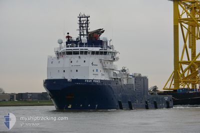
FRAM PRINCE
Tug
Current Trip
| Time Travelled | 3 h, 20 mins |
|---|---|
| Remaining Time | 5 h, 53 mins |
| Distance Travelled | 9.70 nm |
| Remaining Distance | 22.64 nm |
| AVG Speed | 3.9 Noeuds |
| MAX Speed | 4.5 Noeuds |
| AVG Wind | 2.1 knots |
| MAX Wind | 3.6 knots |
| MIN Temp | 10.7°C / 51.26°F |
| MAX Temp | 11.1°C / 51.98°F |
| Tirant d eau | 6.8 m |
| Position reçue | 5 m depuis |
Current Position
| Longitude | -2.06359° |
|---|---|
| Latitude | 56.98309° |
| Etat | Under way using engine |
| Vitesse | 3.1 Noeuds |
| Parcours | 196° |
| Zone | North Sea |
| Station | T-AIS |
| Position reçue | 5 m depuis |
Info
Information
The current position of FRAM PRINCE is in North Sea with coordinates 56.98309° / -2.06359° as reported on 2024-05-18 02:32 by AIS to our vessel tracker app. The vessel's current speed is 3.1 Noeuds and is heading at the port of MONTROSE. The estimated time of arrival as calculated by MyShipTracking vessel tracking app is 2024-05-18 08:31 LT
The vessel FRAM PRINCE (IMO: 9709049, MMSI: 210422000) is a Tug It's sailing under the flag of [CY] Cyprus.
In this page you can find informations about the vessels current position, last detected port calls, and current voyage information. If the vessels is not in coverage by AIS you will find the latest position.
The current position of FRAM PRINCE is detected by our AIS receivers and we are not responsible for the reliability of the data. The last position was recorded while the vessel was in Coverage by the Ais receivers of our vessel tracking app.
The current draught of FRAM PRINCE as reported by AIS is 6.8 meters
Weather
| Temperature | 11.2°C / 52.16°F |
|---|---|
| Wind Speed | 4 knots |
| Direction | 341° NNW |
| Pressure | 1015.7 hPa |
| Humidity | 88.3 % |
| Cloud Coverage | 11 % |
Featured Company
Most Visited Ports (Last year)
| Port | Arrivals | |
|---|---|---|
| 7 | ||
| 5 | ||
| 3 | ||
| 3 | ||
| 2 | ||
| 2 |
Events
| Heure | Evenement | Détails | Position/ Destination | Info |
|---|---|---|---|---|
| 2024-05-17 23:18 | PORT DE DEPART |
|
57.14643 / -2.05555
MONTROSE
|
Vitesse: 5.4 kn Parcours: 56° |
| 2024-05-17 23:06 | Démarrage |
57.14215 / -2.08003
[GB] ABERDEEN
|
Vitesse: 3.1 kn Parcours: 95° |
|
| 2024-05-17 22:50 | Etat Changé | Under way using engine Moored |
57.14195 / -2.08376
[GB] ABERDEEN
|
Vitesse: Parcours: 99° |
| 2024-05-17 22:49 | Changement de destination | MONTROSE ABERDEEN |
57.14195 / -2.08376
[GB] ABERDEEN
|
Vitesse: Parcours: 99° |
| 2024-05-17 22:49 | Changement d'ETA | 2024/05/18 11:45 2024/05/17 19:30 |
57.14195 / -2.08376
[GB] ABERDEEN
|
Vitesse: Parcours: 99° |
| 2024-05-17 22:06 | Changement d'ETA | 2024/05/17 19:30 2024/05/17 21:30 |
57.14194 / -2.08376
[GB] ABERDEEN
|
Vitesse: Parcours: 101° |
| 2024-05-17 22:00 | Etat Changé | Moored Under way using engine |
57.14194 / -2.08375
[GB] ABERDEEN
|
Vitesse: Parcours: 100° |
| 2024-05-17 21:32 | Arret |
57.14246 / -2.07608
[GB] ABERDEEN
|
Vitesse: 0.3 kn Parcours: 29° |
|
| 2024-05-17 21:19 | Port d'arrivée |
|
57.14546 / -2.05841
[GB] ABERDEEN
|
Vitesse: 6.4 kn Parcours: 239.7° |
| 2024-05-17 20:55 | Démarrage | 2.11 nm, South East of ABERDEEN ANCH |
57.16385 / -1.98864
ABERDEEN
|
Vitesse: 3.9 kn Parcours: 254° |