
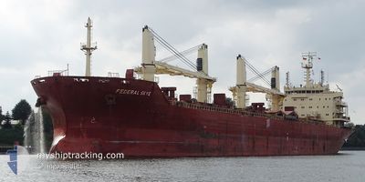
FEDERAL SKYE
Bulk Carrier
Current Trip
BRVDC
| Time Travelled | 1 day |
|---|---|
| Remaining Time | --- |
| Distance Travelled | 387.97 nm |
| Remaining Distance | --- |
| AVG Speed | 10.8 Noeuds |
| MAX Speed | 12.8 Noeuds |
| AVG Wind | 13 knots |
| MAX Wind | 18.1 knots |
| MIN Temp | 25.3°C / 77.54°F |
| MAX Temp | 29.6°C / 85.28°F |
| Tirant d eau | 6.6 m |
| Position reçue | 5 d depuis |
Current Position
| Longitude | -48.75577° |
|---|---|
| Latitude | -1.50238° |
| Etat | Under way using engine |
| Vitesse | 7.9 Noeuds |
| Parcours | 210.5° |
| Zone | South Atlantic Ocean |
| Station | T-AIS |
| Position reçue | 5 d depuis |
Info
Information
The current position of FEDERAL SKYE is in South Atlantic Ocean with coordinates -1.50238° / -48.75577° as reported on 2024-05-08 01:26 by AIS to our vessel tracker app. The vessel's current speed is 7.9 Noeuds
The vessel FEDERAL SKYE (IMO: 9606833, MMSI: 538004385) is a Bulk Carrier that was built in 2012 ( 12 Age ). It's sailing under the flag of [MH] Marshall Is.
In this page you can find informations about the vessels current position, last detected port calls, and current voyage information. If the vessels is not in coverage by AIS you will find the latest position.
The current position of FEDERAL SKYE is detected by our AIS receivers and we are not responsible for the reliability of the data. The last position was recorded while the vessel was in Coverage by the Ais receivers of our vessel tracking app.
The current draught of FEDERAL SKYE as reported by AIS is 6.6 meters
Weather
| Temperature | 28.2°C / 82.76°F |
|---|---|
| Wind Speed | 18 knots |
| Direction | 56° NE |
| Pressure | 1012 hPa |
| Humidity | 78.4 % |
| Cloud Coverage | 100 % |
Featured Company
Last Port Calls
| Port | Arrival | Departure | Time In Port |
|---|---|---|---|
| 2024-05-08 02:05 | 2024-05-11 16:01 | 3 d | |
| 2024-04-09 23:46 | 2024-04-13 22:46 | 3 d | |
| 2024-03-04 16:21 | 2024-03-09 08:25 | 4 d | |
| 2024-03-04 10:39 |
Last Trips
| Origin | Departure | Destination | Arrival | Distance | |
|---|---|---|---|---|---|
| 2024-04-13 22:46 | 2024-05-07 23:05 | 3609.01 nm | |||
| 2024-03-09 03:25 | 2024-04-09 23:46 | 3568.15 nm | |||
| 2024-03-04 05:39 | 2024-03-04 11:21 | 19.74 nm |
Events
| Heure | Evenement | Détails | Position/ Destination | Info |
|---|---|---|---|---|
| 2024-05-11 16:01 | PORT DE DEPART |
|
-1.52683 / -48.75530
BRVDC
|
Vitesse: 4.9 kn Parcours: 20° |
| 2024-05-11 15:56 | Démarrage |
-1.53555 / -48.75772
[BR] VILA DO CONDE
|
Vitesse: 4.9 kn Parcours: 20° |
|
| 2024-05-08 02:25 | Arret |
-1.54164 / -48.75558
[BR] VILA DO CONDE
|
Vitesse: 0.3 kn Parcours: 49° |
|
| 2024-05-08 02:05 | Port d'arrivée |
|
-1.54226 / -48.76347
[BR] VILA DO CONDE
|
Vitesse: 1.1 kn Parcours: 106° |
| 2024-05-08 01:33 | Etat Changé | Default Under way using engine |
-1.51480 / -48.76337
BRVDC
|
Vitesse: 7.9 kn Parcours: 210.5° |
| 2024-05-08 01:26 | Hors de la zone couverte |
-1.50238 / -48.75577
South Atlantic Ocean
[BR] VILA DO CONDE
|
Vitesse: 7.9 kn Parcours: 210.5° |
|
| 2024-05-08 01:12 | Etat Changé | Under way using engine Default |
-1.47697 / -48.74435
BRVDC
|
Vitesse: 2.7 kn Parcours: 145° |
| 2024-05-08 01:12 | Démarrage | 3.35 nm, North of VILA DO CONDE |
-1.47697 / -48.74435
BRVDC
|
Vitesse: 5.1 kn Parcours: 195.7° |
| 2024-05-08 01:12 | Dans la zone couverte |
-1.48052 / -48.74551
South Atlantic Ocean
|
Vitesse: 6.1 kn Parcours: 202.3° |