

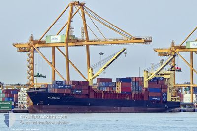
FALMOUTH
Container Ship

Current Trip
HNPCR
| Time Travelled | 1 day |
|---|---|
| Remaining Time | --- |
| Distance Travelled | 239.01 nm |
| Remaining Distance | --- |
| AVG Speed | 10.2 Noeuds |
| MAX Speed | 10.8 Noeuds |
| AVG Wind | 8.9 knots |
| MAX Wind | 12.8 knots |
| MIN Temp | 25.8°C / 78.44°F |
| MAX Temp | 26.6°C / 79.88°F |
| Tirant d eau | 7.9 m |
| Position reçue | 2 d depuis |
Current Position
| Longitude | --- |
|---|---|
| Latitude | --- |
| Etat | Under way using engine |
| Vitesse | 11.7 Noeuds |
| Parcours | 93.8° |
| Zone | Caribbean Sea |
| Station | T-AIS |
| Position reçue | 2 d depuis |
Information
The current position of FALMOUTH is in Caribbean Sea with coordinates 15.91879° / -88.20667° as reported on 2025-02-27 22:22 by AIS to our vessel tracker app. The vessel's current speed is 11.7 Noeuds
The vessel FALMOUTH (IMO: 9266530, MMSI: 210057000) is a Container Ship that was built in 2002 ( 23 Age ). It's sailing under the flag of [CY] Cyprus.
In this page you can find informations about the vessels current position, last detected port calls, and current voyage information. If the vessels is not in coverage by AIS you will find the latest position.
The current position of FALMOUTH is detected by our AIS receivers and we are not responsible for the reliability of the data. The last position was recorded while the vessel was in Coverage by the Ais receivers of our vessel tracking app.
The current draught of FALMOUTH as reported by AIS is 7.9 meters
Weather
| Temperature | 26.3°C / 79.34°F |
|---|---|
| Wind Speed | 10 knots |
| Direction | 14° NNE |
| Pressure | 1013.2 hPa |
| Humidity | 76.2 % |
| Cloud Coverage | 16 % |


Featured Company
Last Port Calls
| Port | Arrival | Departure | Time In Port |
|---|---|---|---|
| 2025-02-28 22:49 | 2025-03-01 16:10 | 17 h | |
| 2025-02-26 21:25 | 2025-02-27 12:11 | 14 h | |
| 2025-02-26 05:12 | 2025-02-26 15:02 | 9 h | |
| 2025-02-19 18:03 | 2025-02-20 10:11 | 16 h | |
| 2025-02-17 05:52 | 2025-02-17 17:32 | 11 h | |
| 2025-02-15 21:52 | 2025-02-16 22:26 | 1 d | |
| 2025-02-10 21:27 | 2025-02-11 12:35 | 15 h | |
| 2025-02-07 17:22 | 2025-02-10 11:06 | 2 d | |
| 2025-02-04 10:23 | 2025-02-05 12:07 | 1 d | |
| 2025-02-02 08:45 | 2025-02-02 21:16 | 12 h |
Most Visited Ports (Last year)
| Port | Arrivals | |
|---|---|---|
| 16 | ||
| 15 | ||
| 15 | ||
| 14 | ||
| 13 | ||
| 3 |
Last Trips
| Origin | Departure | Destination | Arrival | Distance | |
|---|---|---|---|---|---|
| 2025-02-27 12:11 | 2025-02-28 22:49 | 66.76 nm | |||
| 2025-02-26 15:02 | 2025-02-26 21:25 | 64.25 nm | |||
| 2025-02-20 10:11 | 2025-02-26 05:12 | 695.90 nm | |||
| 2025-02-17 17:32 | 2025-02-19 18:03 | 430.24 nm | |||
| 2025-02-16 22:26 | 2025-02-17 05:52 | 27.54 nm | |||
| 2025-02-11 12:35 | 2025-02-15 21:52 | 1158.88 nm | |||
| 2025-02-10 11:06 | 2025-02-10 21:27 | 65.44 nm | |||
| 2025-02-05 12:07 | 2025-02-07 17:22 | 686.02 nm | |||
| 2025-02-02 21:16 | 2025-02-04 10:23 | 419.87 nm | |||
| 2025-02-01 21:02 | 2025-02-02 08:45 | 40.32 nm |
Events
| Heure | Evenement | Détails | Position/ Destination | Info |
|---|---|---|---|---|
| 2025-03-01 22:10 | PORT DE DEPART |
|
15.83993 / -87.96706
HNPCR
|
Vitesse: 5.6 kn Parcours: 256° |
| 2025-03-01 22:02 | Démarrage |
15.84116 / -87.95215
[HN] PUERTO CORTES
|
Vitesse: 5.6 kn Parcours: 256° |
|
| 2025-03-01 05:13 | Arret |
15.84272 / -87.94605
[HN] PUERTO CORTES
|
Vitesse: 0.3 kn Parcours: 279° |
|
| 2025-03-01 04:49 | Démarrage |
15.83629 / -87.96089
[HN] PUERTO CORTES
|
Vitesse: 4 kn Parcours: 87° |
|
| 2025-03-01 04:49 | Port d'arrivée |
|
15.83629 / -87.96089
[HN] PUERTO CORTES
|
Vitesse: 3.2 kn Parcours: 80° |
| 2025-02-28 00:14 | Arret | 2.26 nm, West of PUERTO CORTES |
15.83348 / -87.98486
HNPCR
|
Vitesse: 0.3 kn Parcours: 19° |
| 2025-02-27 22:22 | Etat Changé | Default Under way using engine |
15.91862 / -88.20437
HNPCR
|
Vitesse: 11.7 kn Parcours: 93.8° |
| 2025-02-27 22:22 | Etat Changé | Under way using engine Default |
15.91879 / -88.20667
HNPCR
|
Vitesse: 11.7 kn Parcours: 94° |
| 2025-02-27 22:22 | Hors de la zone couverte |
15.91879 / -88.20667
Caribbean Sea
HNPCR
|
Vitesse: 11.7 kn Parcours: 93.8° |
|
| 2025-02-27 22:16 | Etat Changé | Default Under way using engine |
15.92024 / -88.22651
HNPCR
|
Vitesse: 11.7 kn Parcours: 96° |