
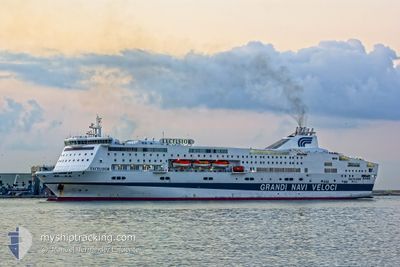
EXCELSIOR
Ro-Ro/Passenger Ship
Current Trip
| Time Travelled | 16 h, 57 mins |
|---|---|
| Remaining Time | 8 h, 4 mins |
| Distance Travelled | 364.40 nm |
| Remaining Distance | 209.21 nm |
| AVG Speed | 21.3 Noeuds |
| MAX Speed | 22.5 Noeuds |
| AVG Wind | 9.1 knots |
| MAX Wind | 20 knots |
| MIN Temp | 11.4°C / 52.52°F |
| MAX Temp | 14.4°C / 57.92°F |
| Tirant d eau | 6.4 m |
| Position reçue | 1 h, 46 m depuis |
Current Position
| Longitude | --- |
|---|---|
| Latitude | --- |
| Etat | Under way using engine |
| Vitesse | 21.9 Noeuds |
| Parcours | 229° |
| Zone | Mediterranean Sea - Western Basin |
| Station | T-AIS |
| Position reçue | 1 h, 46 m depuis |
Information
The current position of EXCELSIOR is in Mediterranean Sea - Western Basin with coordinates 36.89843° / -1.50803° as reported on 2025-02-04 01:08 by AIS to our vessel tracker app. The vessel's current speed is 21.9 Noeuds and is heading at the port of TANGER MED. The estimated time of arrival as calculated by MyShipTracking vessel tracking app is 2025-02-04 10:58 LT
The vessel EXCELSIOR (IMO: 9184419, MMSI: 247351100) is a Ro-Ro/Passenger Ship that was built in 1999 ( 26 Age ). It's sailing under the flag of [IT] Italy.
In this page you can find informations about the vessels current position, last detected port calls, and current voyage information. If the vessels is not in coverage by AIS you will find the latest position.
The current position of EXCELSIOR is detected by our AIS receivers and we are not responsible for the reliability of the data. The last position was recorded while the vessel was in Coverage by the Ais receivers of our vessel tracking app.
The current draught of EXCELSIOR as reported by AIS is 6.4 meters
Weather
| Temperature | 13.8°C / 56.84°F |
|---|---|
| Wind Speed | 20 knots |
| Direction | 33° NNE |
| Pressure | 1023.4 hPa |
| Humidity | 75.6 % |
| Cloud Coverage | 100 % |
Featured Company
Last Port Calls
| Port | Arrival | Departure | Time In Port |
|---|---|---|---|
| 2025-02-03 05:02 | 2025-02-03 09:57 | 4 h | |
| 2025-02-02 07:16 | 2025-02-02 19:22 | 12 h | |
| 2025-02-01 12:18 | 2025-02-01 19:20 | 7 h | |
| 2025-01-31 08:18 | 2025-01-31 16:07 | 7 h | |
| 2025-01-30 06:00 | 2025-01-30 09:50 | 3 h | |
| 2025-01-29 11:41 | 2025-01-29 18:53 | 7 h | |
| 2025-01-29 01:53 | 2025-01-29 04:29 | 2 h | |
| 2025-01-27 16:14 | 2025-01-28 01:48 | 9 h | |
| 2025-01-26 09:23 | 2025-01-26 13:03 | 3 h | |
| 2025-01-24 05:44 | 2025-01-25 16:05 | 1 d |
Last Trips
| Origin | Departure | Destination | Arrival | Distance | |
|---|---|---|---|---|---|
| 2025-02-02 20:22 | 2025-02-03 06:02 | 163.01 nm | |||
| 2025-02-01 20:20 | 2025-02-02 08:16 | 164.18 nm | |||
| 2025-01-31 17:07 | 2025-02-01 13:18 | 442.14 nm | |||
| 2025-01-30 10:50 | 2025-01-31 09:18 | 456.89 nm | |||
| 2025-01-29 19:53 | 2025-01-30 07:00 | 173.01 nm | |||
| 2025-01-29 05:29 | 2025-01-29 12:41 | 159.33 nm | |||
| 2025-01-28 02:48 | 2025-01-29 02:53 | 538.70 nm | |||
| 2025-01-26 14:03 | 2025-01-27 17:14 | 536.72 nm | |||
| 2025-01-25 17:05 | 2025-01-26 10:23 | 356.44 nm | |||
| 2025-01-23 11:59 | 2025-01-24 06:44 | 358.57 nm |
Events
| Heure | Evenement | Détails | Position/ Destination | Info |
|---|---|---|---|---|
| 2025-02-04 01:15 | Etat Changé | Default Under way using engine |
36.87009 / -1.54749
MAPTM
|
Vitesse: 21.9 kn Parcours: 229° |
| 2025-02-04 01:08 | Etat Changé | Under way using engine Default |
36.89843 / -1.50803
MAPTM
|
Vitesse: 21.9 kn Parcours: 229° |
| 2025-02-04 01:08 | Hors de la zone couverte |
36.89843 / -1.50803
Mediterranean Sea - Western Basin
MAPTM
|
Vitesse: 21.9 kn Parcours: 229° |
|
| 2025-02-04 00:57 | Dans la zone couverte |
36.89843 / -1.50803
Mediterranean Sea - Western Basin
MAPTM
|
Vitesse: 21.9 kn Parcours: 229° |
|
| 2025-02-03 23:45 | Etat Changé | Default Under way using engine |
37.23156 / -1.03758
MAPTM
|
Vitesse: 21.1 kn Parcours: 227.8° |
| 2025-02-03 23:41 | Hors de la zone couverte |
37.24425 / -1.02019
Mediterranean Sea - Western Basin
MAPTM
|
Vitesse: 21.1 kn Parcours: 227.8° |
|
| 2025-02-03 22:34 | Etat Changé | Under way using engine Default |
37.50977 / -.65173
MAPTM
|
Vitesse: 21.7 kn Parcours: 228° |
| 2025-02-03 22:27 | Etat Changé | Default Under way using engine |
37.53699 / -.61503
MAPTM
|
Vitesse: 21.4 kn Parcours: 217.6° |
| 2025-02-03 20:13 | Changement de zone | Spanish part of the Mediterranean Sea - Western Basin Spanish part of the Balearic Sea |
38.17340 / -.05317
Mediterranean Sea - Western Basin
MAPTM
|
Vitesse: 21.2 kn Parcours: 210° |
| 2025-02-03 20:13 | Etat Changé | Under way using engine Default |
38.17340 / -.05317
MAPTM
|
Vitesse: 21.5 kn Parcours: 210° |