
ERGE
General Cargo
Current Trip
| Time Travelled | 1 day |
|---|---|
| Remaining Time | --- |
| Distance Travelled | 246.72 nm |
| Remaining Distance | --- |
| AVG Speed | 9.7 Noeuds |
| MAX Speed | 11.5 Noeuds |
| AVG Wind | 8.6 knots |
| MAX Wind | 18 knots |
| MIN Temp | 14.4°C / 57.92°F |
| MAX Temp | 20.1°C / 68.18°F |
| Tirant d eau | 3.6 m |
| Position reçue | 2 m depuis |
Current Position
| Longitude | --- |
|---|---|
| Latitude | --- |
| Etat | Under way using engine |
| Vitesse | 10.6 Noeuds |
| Parcours | 65.7° |
| Zone | Sea of Marmara |
| Station | T-AIS |
| Position reçue | 2 m depuis |
Info
Information
The current position of ERGE is in Sea of Marmara with coordinates 40.21190° / 26.43855° as reported on 2025-03-15 18:25 by AIS to our vessel tracker app. The vessel's current speed is 10.6 Noeuds and is heading at the port of BANDIRMA. The estimated time of arrival as calculated by MyShipTracking vessel tracking app is 2025-03-16 02:00 LT
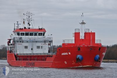
The vessel ERGE (IMO: 9508603, MMSI: 351429000) is a General Cargo that was built in 2010 ( 15 Age ). It's sailing under the flag of [PA] Panama.
In this page you can find informations about the vessels current position, last detected port calls, and current voyage information. If the vessels is not in coverage by AIS you will find the latest position.
The current position of ERGE is detected by our AIS receivers and we are not responsible for the reliability of the data. The last position was recorded while the vessel was in Coverage by the Ais receivers of our vessel tracking app.
The current draught of ERGE as reported by AIS is 3.6 meters
Weather
| Temperature | 18.9°C / 66.02°F |
|---|---|
| Wind Speed | 8 knots |
| Direction | 190° S |
| Pressure | 1015.3 hPa |
| Humidity | 34.3 % |
| Cloud Coverage | 92 % |
Featured Company
Last Port Calls
| Port | Arrival | Departure | Time In Port |
|---|---|---|---|
| 2025-03-11 17:24 | 2025-03-14 18:30 | 3 d | |
| 2025-03-07 09:19 | 2025-03-08 13:37 | 1 d | |
| 2025-03-03 05:10 | 2025-03-04 14:58 | 1 d | |
| 2025-02-21 11:01 | 2025-02-23 17:09 | 2 d | |
| 2025-02-19 15:24 | 2025-02-20 17:11 | 1 d | |
| 2025-02-17 09:48 | 2025-02-18 05:11 | 19 h | |
| 2025-02-06 04:31 | 2025-02-09 17:01 | 3 d | |
| 2025-02-04 08:26 | 2025-02-05 20:13 | 1 d | |
| 2025-01-19 23:12 | 2025-01-26 16:24 | 6 d | |
| 2025-01-16 11:10 | 2025-01-18 00:41 | 1 d |
Last Trips
| Origin | Departure | Destination | Arrival | Distance | |
|---|---|---|---|---|---|
| 2025-03-08 13:37 | 2025-03-11 17:24 | 583.34 nm | |||
| 2025-03-04 14:58 | 2025-03-07 09:19 | 245.19 nm | |||
| 2025-02-23 17:09 | 2025-03-03 05:10 | 1153.13 nm | |||
| 2025-02-20 17:11 | 2025-02-21 11:01 | 113.50 nm | |||
| 2025-02-18 05:11 | 2025-02-19 15:24 | 275.95 nm | |||
| 2025-02-09 17:01 | 2025-02-17 09:48 | 1240.01 nm | |||
| 2025-02-05 20:13 | 2025-02-06 04:31 | 78.17 nm | |||
| 2025-01-26 16:24 | 2025-02-04 08:26 | 1724.00 nm | |||
| 2025-01-18 00:41 | 2025-01-19 23:12 | 279.02 nm | |||
| 2025-01-09 15:05 | 2025-01-16 11:10 | 1200.04 nm |
Events
| Heure | Evenement | Détails | Position/ Destination | Info |
|---|---|---|---|---|
| 2025-03-15 16:58 | Changement de zone | Turkish part of the Sea of Marmara Turkish part of the Aegean Sea |
40.03267 / 26.26654
Sea of Marmara
TRBDM
|
Vitesse: 9.8 kn Parcours: 60.7° |
| 2025-03-15 16:56 | Etat Changé | Under way using engine Default |
40.03002 / 26.26028
TRBDM
|
Vitesse: 9.7 kn Parcours: 74° |
| 2025-03-15 16:37 | Etat Changé | Default Under way using engine |
40.01934 / 26.20134
TRBDM
|
Vitesse: 8.8 kn Parcours: 77.2° |
| 2025-03-15 16:29 | Etat Changé | Under way using engine Default |
40.01609 / 26.18062
TRBDM
|
Vitesse: 9.1 kn Parcours: 70° |
| 2025-03-15 16:20 | Etat Changé | Default Under way using engine |
40.00815 / 26.14799
TRBDM
|
Vitesse: 9.1 kn Parcours: 73.3° |
| 2025-03-15 16:11 | Etat Changé | Under way using engine Default |
40.00191 / 26.12114
TRBDM
|
Vitesse: 9.5 kn Parcours: 76° |
| 2025-03-15 16:05 | Etat Changé | Default Under way using engine |
39.99828 / 26.10309
TRBDM
|
Vitesse: 9.4 kn Parcours: 75.7° |
| 2025-03-15 16:00 | Etat Changé | Under way using engine Default |
39.99495 / 26.08704
TRBDM
|
Vitesse: 9.4 kn Parcours: 74° |
| 2025-03-15 15:50 | Etat Changé | Default Under way using engine |
39.98761 / 26.05354
TRBDM
|
Vitesse: 9.4 kn Parcours: 71.6° |
| 2025-03-15 15:44 | Etat Changé | Under way using engine Default |
39.98285 / 26.03326
TRBDM
|
Vitesse: 10.5 kn Parcours: 41° |