

EM ZENITH
Oil Products Tanker

Current Trip
| Time Travelled | 17 days |
|---|---|
| Remaining Time | --- |
| Distance Travelled | 1428.01 nm |
| Remaining Distance | 253.23 nm |
| AVG Speed | 11.5 Noeuds |
| MAX Speed | 15 Noeuds |
| AVG Wind | 9.3 knots |
| MAX Wind | 18 knots |
| MIN Temp | 20.5°C / 68.9°F |
| MAX Temp | 29.1°C / 84.38°F |
| Tirant d eau | 11.9 m |
| Position reçue | 16 d depuis |
Current Position
| Longitude | --- |
|---|---|
| Latitude | --- |
| Etat | Under way using engine |
| Vitesse | 12.8 Noeuds |
| Parcours | 103° |
| Zone | Gulf of Oman |
| Station | T-AIS |
| Position reçue | 16 d depuis |
Information
The current position of EM ZENITH is in Gulf of Oman with coordinates 24.93145° / 57.30400° as reported on 2025-03-12 04:11 by AIS to our vessel tracker app. The vessel's current speed is 12.8 Noeuds and is heading at the port of PORT QASIM.
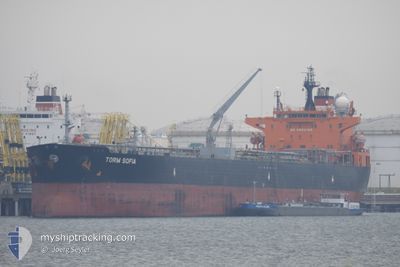
The vessel EM ZENITH (IMO: 9295086, MMSI: 563472000) is a Oil Products Tanker that was built in 2005 ( 20 Age ). It's sailing under the flag of [SG] Singapore.
In this page you can find informations about the vessels current position, last detected port calls, and current voyage information. If the vessels is not in coverage by AIS you will find the latest position.
The current position of EM ZENITH is detected by our AIS receivers and we are not responsible for the reliability of the data. The last position was recorded while the vessel was in Coverage by the Ais receivers of our vessel tracking app.
The current draught of EM ZENITH as reported by AIS is 11.9 meters
Weather
| Temperature | 26.6°C / 79.88°F |
|---|---|
| Wind Speed | 14 knots |
| Direction | --- N |
| Pressure | 1012.6 hPa |
| Humidity | 58 % |
| Cloud Coverage | 1 % |


Featured Company
Most Visited Ports (Last year)
| Port | Arrivals | |
|---|---|---|
| 2 | ||
| 1 | ||
| 1 | ||
| 1 | ||
| 1 | ||
| 1 |
Last Trips
| Origin | Departure | Destination | Arrival | Distance |
|---|
Events
| Heure | Evenement | Détails | Position/ Destination | Info |
|---|---|---|---|---|
| 2025-03-27 07:13 | Démarrage | 9.87 nm, West of SIKKA |
22.45430 / 69.66658
PK BQM
|
Vitesse: 3.8 kn Parcours: 352° |
| 2025-03-25 09:15 | Arret | 9.78 nm, West of SIKKA |
22.45115 / 69.66917
PK BQM
|
Vitesse: 0.3 kn Parcours: 173° |
| 2025-03-25 07:39 | Démarrage | 12.65 nm, West of SIKKA |
22.50947 / 69.61201
PK BQM
|
Vitesse: 5 kn Parcours: 134° |
| 2025-03-24 10:03 | Arret | 13.08 nm, West of SIKKA |
22.51978 / 69.60527
PK BQM
|
Vitesse: 0.2 kn Parcours: 157° |
| 2025-03-24 01:19 | Démarrage |
22.77852 / 68.22767
PK BQM
|
Vitesse: 5.4 kn Parcours: 19° |
|
| 2025-03-20 08:24 | Arret |
22.77467 / 68.23140
PK BQM
|
Vitesse: 0.2 kn Parcours: 270° |
|
| 2025-03-19 19:05 | Démarrage | 2.87 nm, West of PORT QASIM |
24.78840 / 67.27182
PK BQM
|
Vitesse: 8.8 kn Parcours: 283° |