

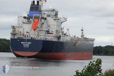
ECO FLEET
Tanker A

Current Trip
| Trip Time | 44 days |
|---|---|
| Trip Distance | 3173.52 nm |
| AVG Speed | 12 Noeuds |
| MAX Speed | 15.2 Noeuds |
| Tirant d eau | 10.5 m |
| AVG Wind | 10.3 knots |
| MAX Wind | 29.9 knots |
| MIN Temp | 2.5°C / 36.5°F |
| MAX Temp | 27.1°C / 80.78°F |
| Position reçue | 2025-02-17 06:18 |
Current Position
| Longitude | --- |
|---|---|
| Latitude | --- |
| Etat | Under way using engine |
| Vitesse | 13.9 Noeuds |
| Parcours | 198.4° |
| Zone | North Atlantic Ocean |
| Station | T-AIS |
| Position reçue | 2025-02-17 06:18 |
Information
The current position of ECO FLEET is in North Atlantic Ocean with coordinates 27.46515° / -15.26888° as reported on 2025-02-17 06:18 by AIS to our vessel tracker app. The vessel's current speed is 13.9 Noeuds and is currently inside the port of CONAKRY.
The vessel ECO FLEET (IMO: 9717503, MMSI: 538005893) is a Tanker A It's sailing under the flag of [MH] Marshall Is.
In this page you can find informations about the vessels current position, last detected port calls, and current voyage information. If the vessels is not in coverage by AIS you will find the latest position.
The current position of ECO FLEET is detected by our AIS receivers and we are not responsible for the reliability of the data. The last position was recorded while the vessel was in Coverage by the Ais receivers of our vessel tracking app.
The current draught of ECO FLEET as reported by AIS is 10.5 meters
Weather
| Temperature | 25.6°C / 78.08°F |
|---|---|
| Wind Speed | 6 knots |
| Direction | 272° W |
| Pressure | 1009.1 hPa |
| Humidity | 79.8 % |
| Cloud Coverage | 100 % |


Featured Company
Last Port Calls
| Port | Arrival | Departure | Time In Port |
|---|---|---|---|
| 2025-03-26 20:19 | |||
| 2025-02-09 09:49 | 2025-02-10 20:04 | 1 d | |
| 2025-02-07 20:00 | 2025-02-09 07:17 | 1 d | |
| 2025-02-01 08:00 | 2025-02-03 06:11 | 1 d | |
| 2025-01-15 07:59 | 2025-01-19 09:39 | 4 d | |
| 2025-01-05 01:41 | 2025-01-06 11:22 | 1 d |
Most Visited Ports (Last year)
| Port | Arrivals | |
|---|---|---|
| 2 | ||
| 2 | ||
| 2 | ||
| 1 | ||
| 1 | ||
| 1 |
Last Trips
| Origin | Departure | Destination | Arrival | Distance | |
|---|---|---|---|---|---|
| 2025-02-10 20:04 | 2025-03-26 20:19 | 3173.52 nm | |||
| 2025-02-09 07:17 | 2025-02-09 09:49 | 20.11 nm | |||
| 2025-02-03 06:11 | 2025-02-07 20:00 | 1170.79 nm | |||
| 2025-01-19 09:39 | 2025-02-01 08:00 | 2745.70 nm | |||
| 2025-01-06 11:22 | 2025-01-15 07:59 | 827.90 nm | |||
| 2024-12-10 08:22 | 2025-01-05 01:41 | 529.30 nm |
Events
| Heure | Evenement | Détails | Position/ Destination | Info |
|---|---|---|---|---|
| 2025-03-26 20:28 | Arret |
9.52240 / -13.71198
[GN] CONAKRY
|
Vitesse: 0.3 kn Parcours: 50° |
|
| 2025-03-26 20:19 | Port d'arrivée |
|
9.52283 / -13.71250
[GN] CONAKRY
|
Vitesse: 4.6 kn Parcours: 5° |
| 2025-03-26 18:23 | Démarrage | 2.33 nm, South East of KASSA |
9.44895 / -13.71604
GNCKY
|
Vitesse: 3.1 kn Parcours: 156° |
| 2025-03-26 17:41 | Arret | 2.05 nm, South East of KASSA |
9.45567 / -13.71645
GNCKY
|
Vitesse: 0.3 kn Parcours: 3° |
| 2025-03-26 15:27 | Démarrage | 2.81 nm, South East of KASSA |
9.44018 / -13.71368
GNCKY
|
Vitesse: 3.2 kn Parcours: 201° |
| 2025-03-26 13:05 | Arret | 2.4 nm, South East of KASSA |
9.44294 / -13.72142
GNCKY
|
Vitesse: 0.3 kn Parcours: 330° |
| 2025-03-26 10:16 | Démarrage | 15.26 nm, South of KASSA |
9.23484 / -13.82917
GNCKY
|
Vitesse: 4.4 kn Parcours: 38° |
| 2025-03-25 15:54 | Arret | 15.94 nm, South of KASSA |
9.22595 / -13.83826
GNCKY
|
Vitesse: 0.2 kn Parcours: 284° |
| 2025-03-25 13:50 | Démarrage | 3.6 nm, South East of KASSA |
9.42392 / -13.71384
GNCKY
|
Vitesse: 4 kn Parcours: 186° |
| 2025-03-25 11:06 | Arret | 3.41 nm, South East of KASSA |
9.42576 / -13.71701
GNCKY
|
Vitesse: 0.3 kn Parcours: 31° |