

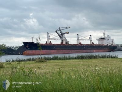
DORYSIA
Bulk Carrier

Current Trip
| Time Travelled | 7 days |
|---|---|
| Remaining Time | --- |
| Distance Travelled | 1691.43 nm |
| Remaining Distance | --- |
| AVG Speed | 9.9 Noeuds |
| MAX Speed | 14.5 Noeuds |
| AVG Wind | 7.7 knots |
| MAX Wind | 15 knots |
| MIN Temp | 23.5°C / 74.3°F |
| MAX Temp | 29.5°C / 85.1°F |
| Tirant d eau | 6.4 m |
| Position reçue | 4 h, 18 m depuis |
Current Position
| Longitude | --- |
|---|---|
| Latitude | --- |
| Etat | Under way using engine |
| Vitesse | 12.9 Noeuds |
| Parcours | 82° |
| Zone | Singapore Strait |
| Station | T-AIS |
| Position reçue | 4 h, 18 m depuis |
Information
The current position of DORYSIA is in Singapore Strait with coordinates 1.24814° / 104.08615° as reported on 2025-03-27 10:47 by AIS to our vessel tracker app. The vessel's current speed is 12.9 Noeuds and is heading at the port of ALBANY. The estimated time of arrival as calculated by MyShipTracking vessel tracking app is 2025-04-05 20:00 LT
The vessel DORYSIA (IMO: 9522910, MMSI: 538008955) is a Bulk Carrier that was built in 2010 ( 15 Age ). It's sailing under the flag of [MH] Marshall Is.
In this page you can find informations about the vessels current position, last detected port calls, and current voyage information. If the vessels is not in coverage by AIS you will find the latest position.
The current position of DORYSIA is detected by our AIS receivers and we are not responsible for the reliability of the data. The last position was recorded while the vessel was in Coverage by the Ais receivers of our vessel tracking app.
The current draught of DORYSIA as reported by AIS is 6.4 meters
Weather
| Temperature | 27.8°C / 82.04°F |
|---|---|
| Wind Speed | 6 knots |
| Direction | 357° N |
| Pressure | 1007.1 hPa |
| Humidity | 76.6 % |
| Cloud Coverage | 14 % |


Featured Company
Last Port Calls
| Port | Arrival | Departure | Time In Port |
|---|---|---|---|
| 2025-03-17 14:40 | 2025-03-20 02:44 | 2 d | |
| 2025-03-03 04:59 | 2025-03-06 01:09 | 2 d | |
| 2025-03-01 01:54 | 2025-03-01 22:34 | 20 h | |
| 2025-02-23 16:15 | 2025-02-26 15:03 | 2 d | |
| 2025-02-17 15:53 | 2025-02-20 05:45 | 2 d | |
| 2025-01-06 23:16 | 2025-01-10 06:36 | 3 d | |
| 2025-01-05 18:37 | 2025-01-06 22:58 | 1 d |
Most Visited Ports (Last year)
| Port | Arrivals | |
|---|---|---|
| 2 | ||
| 2 | ||
| 1 | ||
| 1 | ||
| 1 | ||
| 1 |
Last Trips
| Origin | Departure | Destination | Arrival | Distance | |
|---|---|---|---|---|---|
| 2025-03-06 01:09 | 2025-03-17 14:40 | 3136.03 nm | |||
| 2025-03-01 22:34 | 2025-03-03 04:59 | 388.57 nm | |||
| 2025-02-26 15:03 | 2025-03-01 01:54 | 115.49 nm | |||
| 2025-02-20 05:45 | 2025-02-23 16:15 | 296.18 nm | |||
| 2025-01-10 06:36 | 2025-02-17 15:53 | 10586.32 nm | |||
| 2025-01-06 22:58 | 2025-01-06 23:16 | 1.14 nm | |||
| 2024-12-21 23:55 | 2025-01-05 18:37 | 1270.29 nm |
Events
| Heure | Evenement | Détails | Position/ Destination | Info |
|---|---|---|---|---|
| 2025-03-27 10:54 | Etat Changé | Default Under way using engine |
1.25189 / 104.10980
AUALH
|
Vitesse: 12.9 kn Parcours: 82° |
| 2025-03-27 10:47 | Hors de la zone couverte |
1.24814 / 104.08615
Singapore Strait
AUALH
|
Vitesse: 12.9 kn Parcours: 82° |
|
| 2025-03-27 10:19 | Changement de zone | Indonesian part of the Singapore Strait Singaporean part of the Singapore Strait |
1.24089 / 103.98619
Singapore Strait
AUALH
|
Vitesse: 12.4 kn Parcours: 91.8° |
| 2025-03-27 09:32 | Etat Changé | Under way using engine At anchor |
1.27532 / 103.88546
AUALH
|
Vitesse: 4.7 kn Parcours: 86° |
| 2025-03-27 09:32 | Tirant d'eau modifié | 6.4 5.9 |
1.27520 / 103.88448
AUALH
|
Vitesse: 3.8 kn Parcours: 84° |
| 2025-03-27 09:32 | Changement de destination | AUALH SGSIN |
1.27520 / 103.88448
AUALH
|
Vitesse: 3.8 kn Parcours: 84° |
| 2025-03-27 09:32 | Changement d'ETA | 2025/04/05 12:00 2025/03/27 07:00 |
1.27520 / 103.88448
AUALH
|
Vitesse: 3.8 kn Parcours: 84° |
| 2025-03-27 09:31 | Démarrage | 2.06 nm, North East of SINGAPORE |
1.27510 / 103.88414
SGSIN
|
Vitesse: 3.2 kn Parcours: 81° |
| 2025-03-27 00:39 | Etat Changé | At anchor Under way using engine |
1.27332 / 103.88313
SGSIN
|
Vitesse: Parcours: 47° |
| 2025-03-27 00:19 | Arret | 1.97 nm, North East of SINGAPORE |
1.27246 / 103.88389
SGSIN
|
Vitesse: 0.3 kn Parcours: 12° |