

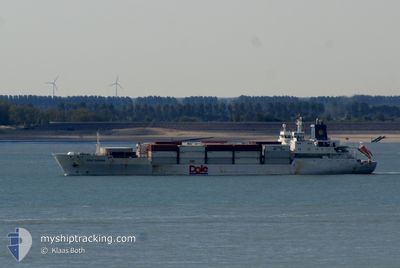
DOLE EUROPA
Cargo

Current Trip
| Time Travelled | 8 days |
|---|---|
| Remaining Time | --- |
| Distance Travelled | 3376.91 nm |
| Remaining Distance | --- |
| AVG Speed | 16.4 Noeuds |
| MAX Speed | 21.3 Noeuds |
| AVG Wind | 13.4 knots |
| MAX Wind | 31 knots |
| MIN Temp | 2.3°C / 36.14°F |
| MAX Temp | 24.6°C / 76.28°F |
| Tirant d eau | 8 m |
| Position reçue | 4 d depuis |
Current Position
| Longitude | --- |
|---|---|
| Latitude | --- |
| Etat | Under way using engine |
| Vitesse | 15.8 Noeuds |
| Parcours | 234.2° |
| Zone | North Atlantic Ocean |
| Station | T-AIS |
| Position reçue | 4 d depuis |
Information
The current position of DOLE EUROPA is in North Atlantic Ocean with coordinates 36.30245° / -25.83266° as reported on 2025-02-17 02:42 by AIS to our vessel tracker app. The vessel's current speed is 15.8 Noeuds and is heading at the port of SAN JUAN. The estimated time of arrival as calculated by MyShipTracking vessel tracking app is 2025-02-24 08:00 LT
The vessel DOLE EUROPA (IMO: 9046514, MMSI: 311296000) is a Cargo It's sailing under the flag of [BS] Bahamas.
In this page you can find informations about the vessels current position, last detected port calls, and current voyage information. If the vessels is not in coverage by AIS you will find the latest position.
The current position of DOLE EUROPA is detected by our AIS receivers and we are not responsible for the reliability of the data. The last position was recorded while the vessel was in Coverage by the Ais receivers of our vessel tracking app.
The current draught of DOLE EUROPA as reported by AIS is 8 meters
Weather
| Temperature | 24.4°C / 75.92°F |
|---|---|
| Wind Speed | 11 knots |
| Direction | 149° SSE |
| Pressure | 1019.1 hPa |
| Humidity | 72.6 % |
| Cloud Coverage | --- |


Featured Company
Last Port Calls
| Port | Arrival | Departure | Time In Port |
|---|---|---|---|
| 2025-02-10 23:50 | 2025-02-13 02:54 | 2 d | |
| 2025-01-31 13:33 | 2025-01-31 21:08 | 7 h | |
| 2025-01-27 11:03 | 2025-01-28 07:01 | 19 h | |
| 2025-01-24 00:45 | 2025-01-26 08:47 | 2 d | |
| 2025-01-22 23:05 | 2025-01-23 06:53 | 7 h | |
| 2025-01-20 12:02 | 2025-01-20 20:04 | 8 h | |
| 2025-01-07 01:02 | 2025-01-09 09:04 | 2 d | |
| 2024-12-27 13:42 | 2024-12-27 21:16 | 7 h | |
| 2024-12-23 11:44 | 2024-12-24 06:57 | 19 h | |
| 2024-12-20 12:51 | 2024-12-22 06:55 | 1 d |
Most Visited Ports (Last year)
| Port | Arrivals | |
|---|---|---|
| 21 | ||
| 11 | ||
| 11 | ||
| 11 | ||
| 9 |
Last Trips
| Origin | Departure | Destination | Arrival | Distance | |
|---|---|---|---|---|---|
| 2025-01-31 17:08 | 2025-02-11 00:50 | 3924.14 nm | |||
| 2025-01-28 01:01 | 2025-01-31 09:33 | 1137.61 nm | |||
| 2025-01-26 03:47 | 2025-01-27 05:03 | 414.69 nm | |||
| 2025-01-23 01:53 | 2025-01-23 19:45 | 278.20 nm | |||
| 2025-01-20 16:04 | 2025-01-22 18:05 | 667.27 nm | |||
| 2025-01-09 10:04 | 2025-01-20 08:02 | 4010.31 nm | |||
| 2024-12-27 17:16 | 2025-01-07 02:02 | 4059.94 nm | |||
| 2024-12-24 00:57 | 2024-12-27 09:42 | 1134.91 nm | |||
| 2024-12-22 01:55 | 2024-12-23 05:44 | 417.65 nm | |||
| 2024-12-19 06:02 | 2024-12-20 07:51 | 316.46 nm |
Events
| Heure | Evenement | Détails | Position/ Destination | Info |
|---|---|---|---|---|
| 2025-02-17 02:52 | Etat Changé | Default Under way using engine |
36.27565 / -25.87954
PR SJU
|
Vitesse: 15.8 kn Parcours: 234.2° |
| 2025-02-17 02:42 | Hors de la zone couverte |
36.30245 / -25.83266
North Atlantic Ocean
PR SJU
|
Vitesse: 15.8 kn Parcours: 234.2° |
|
| 2025-02-16 19:51 | Etat Changé | Under way using engine Default |
37.47201 / -23.93167
PR SJU
|
Vitesse: 16.8 kn Parcours: 233° |
| 2025-02-16 19:44 | Etat Changé | Default Under way using engine |
37.48972 / -23.90198
PR SJU
|
Vitesse: 16.9 kn Parcours: 233.2° |
| 2025-02-16 19:37 | Etat Changé | Under way using engine Default |
37.51179 / -23.86518
PR SJU
|
Vitesse: 16.8 kn Parcours: 233° |
| 2025-02-16 19:29 | Etat Changé | Default Under way using engine |
37.53213 / -23.83139
PR SJU
|
Vitesse: 16.8 kn Parcours: 233.2° |
| 2025-02-16 19:21 | Etat Changé | Under way using engine Default |
37.55647 / -23.79102
PR SJU
|
Vitesse: 16.7 kn Parcours: 234° |
| 2025-02-16 19:14 | Etat Changé | Default Under way using engine |
37.57550 / -23.75840
PR SJU
|
Vitesse: 16.7 kn Parcours: 233.9° |
| 2025-02-16 19:10 | Changement de zone | Portuguese (Azores) part of the North Atlantic Ocean United Kingdom part of the English Channel |
37.58675 / -23.73904
North Atlantic Ocean
PR SJU
|
Vitesse: 16.7 kn Parcours: 233.9° |
| 2025-02-16 19:10 | Etat Changé | Under way using engine Default |
37.58675 / -23.73904
PR SJU
|
Vitesse: 16.9 kn Parcours: 234° |