

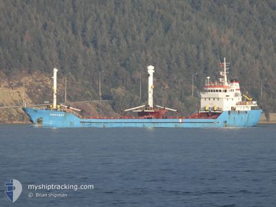
DOGANAY
Cargo

Current Trip
| Time Travelled | 2 days |
|---|---|
| Remaining Time | --- |
| Distance Travelled | 567.12 nm |
| Remaining Distance | --- |
| AVG Speed | 8.8 Noeuds |
| MAX Speed | 9.7 Noeuds |
| AVG Wind | 12.7 knots |
| MAX Wind | 27.7 knots |
| MIN Temp | 10°C / 50°F |
| MAX Temp | 14.7°C / 58.46°F |
| Tirant d eau | 0 m |
| Position reçue | 4 h, 37 m depuis |
Current Position
| Longitude | --- |
|---|---|
| Latitude | --- |
| Etat | Under way using engine |
| Vitesse | 8.8 Noeuds |
| Parcours | 156.8° |
| Zone | Ionian Sea |
| Station | T-AIS |
| Position reçue | 4 h, 37 m depuis |
Information
The current position of DOGANAY is in Ionian Sea with coordinates 38.03416° / 20.98473° as reported on 2025-02-28 22:57 by AIS to our vessel tracker app. The vessel's current speed is 8.8 Noeuds and is heading at the port of AGIOS CHARALAMPOS. The estimated time of arrival as calculated by MyShipTracking vessel tracking app is 2025-03-02 10:00 LT
The vessel DOGANAY (IMO: 887658400, MMSI: 518857000) is a Cargo It's sailing under the flag of [CK] Cook Is.
In this page you can find informations about the vessels current position, last detected port calls, and current voyage information. If the vessels is not in coverage by AIS you will find the latest position.
The current position of DOGANAY is detected by our AIS receivers and we are not responsible for the reliability of the data. The last position was recorded while the vessel was in Coverage by the Ais receivers of our vessel tracking app.
Weather
| Temperature | 12°C / 53.6°F |
|---|---|
| Wind Speed | 4 knots |
| Direction | 61° ENE |
| Pressure | 1021.3 hPa |
| Humidity | 80.4 % |
| Cloud Coverage | 100 % |


Featured Company
Last Port Calls
| Port | Arrival | Departure | Time In Port |
|---|---|---|---|
| 2025-02-24 06:56 | 2025-02-26 07:59 | 2 d | |
| 2025-02-21 07:55 | 2025-02-22 12:30 | 1 d | |
| 2025-02-12 09:45 | |||
| 2025-02-10 12:53 | 2025-02-10 22:17 | 9 h | |
| 2025-02-06 10:58 | 2025-02-10 11:57 | 4 d | |
| 2025-02-05 22:17 | 2025-02-06 10:25 | 12 h | |
| 2025-01-23 11:13 | 2025-01-27 16:25 | 4 d | |
| 2025-01-18 16:13 | 2025-01-20 17:14 | 2 d | |
| 2025-01-11 08:49 | 2025-01-16 16:53 | 5 d |
Last Trips
| Origin | Departure | Destination | Arrival | Distance | |
|---|---|---|---|---|---|
| 2025-02-22 12:30 | 2025-02-24 06:56 | 104.44 nm | |||
| 2025-02-10 22:17 | 2025-02-12 09:45 | 258.47 nm | |||
| 2025-02-10 11:57 | 2025-02-10 12:53 | 4.70 nm | |||
| 2025-02-06 10:25 | 2025-02-06 10:58 | 4.55 nm | |||
| 2025-01-27 16:25 | 2025-02-05 22:17 | 678.84 nm | |||
| 2025-01-20 17:14 | 2025-01-23 11:13 | 134.43 nm | |||
| 2025-01-16 16:53 | 2025-01-18 16:13 | 386.95 nm | |||
| 2024-12-18 19:13 | 2025-01-11 08:49 | 1762.54 nm |
Events
| Heure | Evenement | Détails | Position/ Destination | Info |
|---|---|---|---|---|
| 2025-02-28 23:05 | Etat Changé | Default Under way using engine |
38.01579 / 20.99495
GRKLM
|
Vitesse: 8.8 kn Parcours: 156.8° |
| 2025-02-28 22:57 | Hors de la zone couverte |
38.03416 / 20.98473
Ionian Sea
GRKLM
|
Vitesse: 8.8 kn Parcours: 156.8° |
|
| 2025-02-28 22:15 | Etat Changé | Under way using engine Default |
38.13093 / 20.93822
GRKLM
|
Vitesse: 9.1 kn Parcours: 160° |
| 2025-02-28 21:49 | Etat Changé | Default Under way using engine |
38.19498 / 20.90799
GRKLM
|
Vitesse: 9.2 kn Parcours: 159.2° |
| 2025-02-28 20:20 | Etat Changé | Under way using engine Default |
38.40184 / 20.78351
GRKLM
|
Vitesse: 9.2 kn Parcours: 150° |
| 2025-02-28 20:02 | Etat Changé | Default Under way using engine |
38.44156 / 20.75406
GRKLM
|
Vitesse: 9.5 kn Parcours: 151° |
| 2025-02-28 19:25 | Etat Changé | Under way using engine Default |
38.51922 / 20.68396
GRKLM
|
Vitesse: 8.8 kn Parcours: 101° |
| 2025-02-28 18:53 | Etat Changé | Default Under way using engine |
38.53351 / 20.58686
GRKLM
|
Vitesse: 8.4 kn Parcours: 152.5° |
| 2025-02-28 18:26 | Changement de zone | Greek part of the Ionian Sea Italian part of the Adriatic Sea |
38.55647 / 20.50927
Ionian Sea
GRKLM
|
Vitesse: 8.4 kn Parcours: 152.5° |
| 2025-02-28 18:25 | Dans la zone couverte |
38.55647 / 20.50927
Ionian Sea
GRKLM
|
Vitesse: 8.4 kn Parcours: 152.5° |