

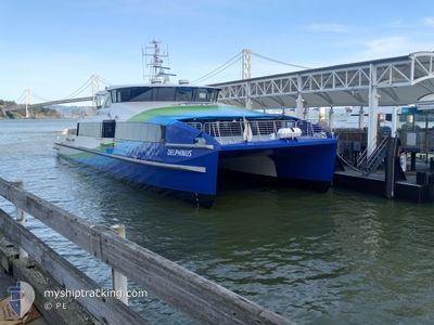
DELPHINUS
High speed craft

Current Trip
| Time Travelled | 56 mins |
|---|---|
| Remaining Time | 2 h, 0 mins |
| Distance Travelled | 18.00 nm |
| Remaining Distance | --- |
| AVG Speed | 20.2 Noeuds |
| MAX Speed | 20.2 Noeuds |
| AVG Wind | 4.6 knots |
| MAX Wind | 6.9 knots |
| MIN Temp | 14.6°C / 58.28°F |
| MAX Temp | 17.2°C / 62.96°F |
| Tirant d eau | 1.3 m |
| Position reçue | 1 m depuis |
Current Position
| Longitude | --- |
|---|---|
| Latitude | --- |
| Etat | Under way using engine |
| Vitesse | 33.6 Noeuds |
| Parcours | 166° |
| Zone | North Pacific Ocean |
| Station | T-AIS |
| Position reçue | 1 m depuis |
Information
The current position of DELPHINUS is in North Pacific Ocean with coordinates 37.80158° / -122.34923° as reported on 2025-02-23 23:03 by AIS to our vessel tracker app. The vessel's current speed is 33.6 Noeuds and is heading at the port of VALLEJO. The estimated time of arrival as calculated by MyShipTracking vessel tracking app is 2025-02-23 17:05 LT
The vessel DELPHINUS (IMO: 1331494, MMSI: 368341690) is a High speed craft It's sailing under the flag of [US] USA.
In this page you can find informations about the vessels current position, last detected port calls, and current voyage information. If the vessels is not in coverage by AIS you will find the latest position.
The current position of DELPHINUS is detected by our AIS receivers and we are not responsible for the reliability of the data. The last position was recorded while the vessel was in Coverage by the Ais receivers of our vessel tracking app.
The current draught of DELPHINUS as reported by AIS is 1.3 meters
Weather
| Temperature | 14.8°C / 58.64°F |
|---|---|
| Wind Speed | 5 knots |
| Direction | 294° WNW |
| Pressure | 1024.5 hPa |
| Humidity | 69.8 % |
| Cloud Coverage | 100 % |


Featured Company
Last Port Calls
| Port | Arrival | Departure | Time In Port |
|---|---|---|---|
| 2025-02-23 13:57 | 2025-02-23 14:09 | 11 m | |
| 2025-02-23 12:27 | 2025-02-23 13:32 | 1 h | |
| 2025-02-23 11:08 | 2025-02-23 11:19 | 10 m | |
| 2025-02-23 10:17 | 2025-02-23 10:43 | 25 m | |
| 2025-02-21 18:32 | 2025-02-23 09:05 | 1 d | |
| 2025-02-21 17:40 | 2025-02-21 18:22 | 41 m | |
| 2025-02-21 15:54 | 2025-02-21 16:33 | 38 m | |
| 2025-02-21 13:18 | 2025-02-21 13:28 | 9 m | |
| 2025-02-21 12:12 | 2025-02-21 13:09 | 56 m | |
| 2025-02-21 11:51 | 2025-02-21 11:57 | 6 m |
Most Visited Ports (Last year)
| Port | Arrivals | |
|---|---|---|
| 1517 | ||
| 1291 | ||
| 189 | ||
| 11 | ||
| 1 |
Last Trips
| Origin | Departure | Destination | Arrival | Distance | |
|---|---|---|---|---|---|
| 2025-02-23 13:32 | 2025-02-23 13:57 | 2.36 nm | |||
| 2025-02-23 11:19 | 2025-02-23 12:27 | 17.65 nm | |||
| 2025-02-23 10:43 | 2025-02-23 11:08 | 2.37 nm | |||
| 2025-02-23 09:05 | 2025-02-23 10:17 | 19.70 nm | |||
| 2025-02-21 18:22 | 2025-02-21 18:32 | 2.63 nm | |||
| 2025-02-21 16:33 | 2025-02-21 17:40 | 17.46 nm | |||
| 2025-02-21 13:28 | 2025-02-21 15:54 | 27.38 nm | |||
| 2025-02-21 13:09 | 2025-02-21 13:18 | 2.92 nm | |||
| 2025-02-21 11:57 | 2025-02-21 12:12 | 4.34 nm | |||
| 2025-02-21 11:43 | 2025-02-21 11:51 | 2.38 nm |
Events
| Heure | Evenement | Détails | Position/ Destination | Info |
|---|---|---|---|---|
| 2025-02-23 22:42 | Démarrage | 2.49 nm, South East of CHEVRON SF |
37.90772 / -122.36128
SF BAY FERRY
|
Vitesse: 9.5 kn Parcours: 185° |
| 2025-02-23 22:35 | Arret | 2.55 nm, East of CHEVRON SF |
37.90898 / -122.35931
SF BAY FERRY
|
Vitesse: 0.1 kn Parcours: 90° |
| 2025-02-23 22:09 | PORT DE DEPART |
|
37.79812 / -122.38784
SF BAY FERRY
|
Vitesse: 28.8 kn Parcours: 46° |
| 2025-02-23 22:09 | Démarrage |
37.79635 / -122.38975
[US] SAN FRANCISCO
|
Vitesse: 21 kn Parcours: 42° |
|
| 2025-02-23 21:57 | Arret |
37.79491 / -122.39128
[US] SAN FRANCISCO
|
Vitesse: 0.3 kn Parcours: 236° |
|
| 2025-02-23 21:57 | Port d'arrivée |
|
37.79491 / -122.39128
[US] SAN FRANCISCO
|
Vitesse: 1.2 kn Parcours: 237° |
| 2025-02-23 21:47 | Démarrage | 2.24 nm, West of TREASURE ISLAND |
37.81128 / -122.41258
SF BAY FERRY
|
Vitesse: 10 kn Parcours: 56.4° |
| 2025-02-23 21:37 | Arret | 2.26 nm, West of TREASURE ISLAND |
37.80928 / -122.41263
SF BAY FERRY
|
Vitesse: 0.1 kn Parcours: 142° |
| 2025-02-23 21:32 | PORT DE DEPART |
|
37.81252 / -122.40794
SF BAY FERRY
|
Vitesse: 11.5 kn Parcours: 277° |
| 2025-02-23 21:27 | Démarrage |
37.79668 / -122.39074
[US] SAN FRANCISCO
|
Vitesse: 12.3 kn Parcours: 355° |