
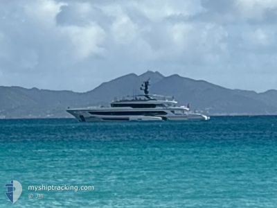
DAYBREAK
Pleasure Craft
Current Trip
ST MAAN
| Trip Time | 10 days |
|---|---|
| Trip Distance | 72.40 nm |
| AVG Speed | 9.5 Noeuds |
| MAX Speed | 13.8 Noeuds |
| Tirant d eau | 0 m |
| AVG Wind | 10.7 knots |
| MAX Wind | 15 knots |
| MIN Temp | 24.8°C / 76.64°F |
| MAX Temp | 26.5°C / 79.7°F |
| Position reçue | 4 m depuis |
Current Position
| Longitude | --- |
|---|---|
| Latitude | --- |
| Etat | Moored |
| Vitesse | |
| Parcours | 217° |
| Zone | Caribbean Sea |
| Station | T-AIS |
| Position reçue | 4 m depuis |
Info
Information
The current position of DAYBREAK is in Caribbean Sea with coordinates 18.03700° / -63.08792° as reported on 2026-01-10 16:11 by AIS to our vessel tracker app. The vessel's current speed is 0 Noeuds and is currently inside the port of ST MAARTEN.
The vessel DAYBREAK (IMO: 9957854, MMSI: 319190900) is a Pleasure Craft It's sailing under the flag of [KY] Cayman Is.
In this page you can find informations about the vessels current position, last detected port calls, and current voyage information. If the vessels is not in coverage by AIS you will find the latest position.
The current position of DAYBREAK is detected by our AIS receivers and we are not responsible for the reliability of the data. The last position was recorded while the vessel was in Coverage by the Ais receivers of our vessel tracking app.
Weather
| Temperature | 26°C / 78.8°F |
|---|---|
| Wind Speed | 12 knots |
| Direction | 70° ENE |
| Pressure | 1016.5 hPa |
| Humidity | 72.7 % |
| Cloud Coverage | --- |
Featured Company
Last Port Calls
| Port | Arrival | Departure | Time In Port |
|---|---|---|---|
| 2026-01-04 14:11 | |||
| 2025-12-20 17:05 | 2025-12-25 10:42 | 4 d | |
| 2025-12-07 16:39 | 2025-12-10 07:39 | 2 d | |
| 2025-12-01 11:47 | |||
| 2025-11-12 10:36 | |||
| 2025-11-11 12:42 | 2025-11-12 08:53 | 20 h | |
| 2025-11-11 08:39 |
Most Visited Ports (Last year)
| Port | Arrivals | |
|---|---|---|
| 6 | ||
| 4 | ||
| 3 | ||
| 3 | ||
| 3 | ||
| 2 |
Last Trips
| Origin | Departure | Destination | Arrival | Distance | |
|---|---|---|---|---|---|
| 2025-12-25 10:42 | 2026-01-04 14:11 | 72.40 nm | |||
| 2025-12-10 07:39 | 2025-12-20 17:05 | 402.35 nm | |||
| 2025-12-01 11:47 | 2025-12-07 16:39 | 156.36 nm | |||
| 2025-11-12 08:53 | 2025-11-12 10:36 | 4.07 nm | |||
| 2025-11-11 08:39 | 2025-11-11 12:42 | 24.71 nm |
Events
| Heure | Evenement | Détails | Position/ Destination | Info |
|---|---|---|---|---|
| 2026-01-08 23:46 | Changement de destination | ST MAAN ST MAARTEN |
18.03698 / -63.08792
[SX] ST MAARTEN
|
Vitesse: Parcours: 217° |
| 2026-01-04 18:56 | Etat Changé | Moored At anchor |
18.03695 / -63.08788
[SX] ST MAARTEN
|
Vitesse: Parcours: 217° |
| 2026-01-04 18:32 | Arret |
18.03695 / -63.08787
[SX] ST MAARTEN
|
Vitesse: Parcours: 217° |
|
| 2026-01-04 18:12 | Démarrage |
18.03583 / -63.09416
[SX] ST MAARTEN
|
Vitesse: 3.4 kn Parcours: 62° |
|
| 2026-01-04 18:11 | Port d'arrivée |
|
18.03569 / -63.09443
[SX] ST MAARTEN
|
Vitesse: 2.9 kn Parcours: 62° |
| 2026-01-04 17:58 | Arret | 0.51 nm, South West of ST MAARTEN |
18.03389 / -63.10041
ST MAARTEN
|
Vitesse: 0.2 kn Parcours: 89° |
| 2026-01-04 17:43 | Démarrage | 1.05 nm, West of ST MAARTEN |
18.03190 / -63.10975
ST MAARTEN
|
Vitesse: 3.8 kn Parcours: 71° |
| 2026-01-04 16:56 | Arret | 1.16 nm, West of ST MAARTEN |
18.03157 / -63.11167
ST MAARTEN
|
Vitesse: 0.2 kn Parcours: 77° |
| 2026-01-04 16:53 | Etat Changé | At anchor Under way using engine |
18.03144 / -63.11138
ST MAARTEN
|
Vitesse: 1.4 kn Parcours: 76° |
| 2026-01-04 16:32 | Changement de zone | Sint-Maarten part of the Caribbean Sea Saint-Martin part of the Caribbean Sea |
18.04064 / -63.15504
Caribbean Sea
ST MAARTEN
|
Vitesse: 11.2 kn Parcours: 129.2° |