
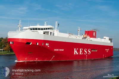
DANUBE HIGHWAY
Vehicles Carrier
Current Trip
| Time Travelled | 9 h, 14 mins |
|---|---|
| Remaining Time | 12 h, 10 mins |
| Distance Travelled | 131.46 nm |
| Remaining Distance | 171.89 nm |
| AVG Speed | 14.5 Noeuds |
| MAX Speed | 18.9 Noeuds |
| AVG Wind | 16.9 knots |
| MAX Wind | 22 knots |
| MIN Temp | 11.3°C / 52.34°F |
| MAX Temp | 15.4°C / 59.72°F |
| Tirant d eau | 7.4 m |
| Position reçue | 1 m depuis |
Current Position
| Longitude | 4.20029° |
|---|---|
| Latitude | 53.05615° |
| Etat | Under way using engine |
| Vitesse | 15 Noeuds |
| Parcours | 227.6° |
| Zone | North Sea |
| Station | T-AIS |
| Position reçue | 1 m depuis |
Info
Information
The current position of DANUBE HIGHWAY is in North Sea with coordinates 53.05615° / 4.20029° as reported on 2024-06-05 06:10 by AIS to our vessel tracker app. The vessel's current speed is 15 Noeuds and is heading at the port of SHEERNESS. The estimated time of arrival as calculated by MyShipTracking vessel tracking app is 2024-06-05 18:21 LT
The vessel DANUBE HIGHWAY (IMO: 9316309, MMSI: 308803000) is a Vehicles Carrier that was built in 2006 ( 18 Age ). It's sailing under the flag of [BS] Bahamas.
In this page you can find informations about the vessels current position, last detected port calls, and current voyage information. If the vessels is not in coverage by AIS you will find the latest position.
The current position of DANUBE HIGHWAY is detected by our AIS receivers and we are not responsible for the reliability of the data. The last position was recorded while the vessel was in Coverage by the Ais receivers of our vessel tracking app.
The current draught of DANUBE HIGHWAY as reported by AIS is 7.4 meters
Weather
| Temperature | 11.4°C / 52.52°F |
|---|---|
| Wind Speed | 15 knots |
| Direction | 285° WNW |
| Pressure | 1010.3 hPa |
| Humidity | 68.5 % |
| Cloud Coverage | 29 % |
Featured Company
Last Port Calls
| Port | Arrival | Departure | Time In Port |
|---|---|---|---|
| 2024-06-04 05:16 | 2024-06-04 20:57 | 15 h | |
| 2024-06-03 09:30 | 2024-06-03 21:36 | 12 h | |
| 2024-05-30 10:50 | 2024-05-31 09:45 | 22 h | |
| 2024-05-29 09:10 | 2024-05-29 20:42 | 11 h | |
| 2024-05-29 00:47 | 2024-05-29 06:23 | 5 h | |
| 2024-05-26 19:10 | 2024-05-27 16:46 | 21 h | |
| 2024-05-24 00:37 | 2024-05-25 02:07 | 1 d | |
| 2024-05-23 10:08 | 2024-05-23 18:08 | 8 h | |
| 2024-05-21 19:29 | 2024-05-22 13:05 | 17 h | |
| 2024-05-16 17:34 | 2024-05-17 13:51 | 20 h |
Last Trips
| Origin | Departure | Destination | Arrival | Distance | |
|---|---|---|---|---|---|
| 2024-06-03 23:36 | 2024-06-04 07:16 | 123.10 nm | |||
| 2024-05-31 12:45 | 2024-06-03 11:30 | 1035.28 nm | |||
| 2024-05-29 23:42 | 2024-05-30 13:50 | 233.12 nm | |||
| 2024-05-29 09:23 | 2024-05-29 12:10 | 46.26 nm | |||
| 2024-05-27 18:46 | 2024-05-29 03:47 | 525.50 nm | |||
| 2024-05-25 04:07 | 2024-05-26 21:10 | 668.11 nm | |||
| 2024-05-23 19:08 | 2024-05-24 02:37 | 98.38 nm | |||
| 2024-05-22 15:05 | 2024-05-23 11:08 | 309.52 nm | |||
| 2024-05-17 15:51 | 2024-05-21 21:29 | 1302.23 nm | |||
| 2024-05-15 20:42 | 2024-05-16 19:34 | 371.07 nm |
Events
| Heure | Evenement | Détails | Position/ Destination | Info |
|---|---|---|---|---|
| 2024-06-05 05:32 | Etat Changé | Under way using engine Default |
53.15598 / 4.38746
SHEERNESS
|
Vitesse: 14.4 kn Parcours: 205° |
| 2024-06-05 05:11 | Etat Changé | Default Under way using engine |
53.23136 / 4.45279
SHEERNESS
|
Vitesse: 14.2 kn Parcours: 206.8° |
| 2024-06-05 04:52 | Etat Changé | Under way using engine Default |
53.29919 / 4.50605
SHEERNESS
|
Vitesse: 14 kn Parcours: 205° |
| 2024-06-05 04:45 | Etat Changé | Default Under way using engine |
53.32167 / 4.52333
SHEERNESS
|
Vitesse: 14.1 kn Parcours: 204.5° |
| 2024-06-04 23:34 | Changement de zone | Dutch part of the North Sea German part of the North Sea |
53.62490 / 6.27682
North Sea
SHEERNESS
|
Vitesse: 15.2 kn Parcours: 267.8° |
| 2024-06-04 23:34 | Etat Changé | Under way using engine Default |
53.62490 / 6.27682
SHEERNESS
|
Vitesse: 10.1 kn Parcours: 286° |
| 2024-06-04 22:56 | Etat Changé | Default Under way using engine |
53.61438 / 6.52898
SHEERNESS
|
Vitesse: 17.9 kn Parcours: 302.3° |
| 2024-06-04 22:22 | Changement de zone | German part of the North Sea Dutch part of the North Sea |
53.52189 / 6.76289
North Sea
SHEERNESS
|
Vitesse: 17.6 kn Parcours: 307.7° |
| 2024-06-04 21:25 | Changement de zone | Dutch part of the North Sea German part of the North Sea |
53.32375 / 7.01894
North Sea
SHEERNESS
|
Vitesse: 13.3 kn Parcours: 287.6° |
| 2024-06-04 20:57 | PORT DE DEPART |
|
53.33376 / 7.17540
SHEERNESS
|
Vitesse: 7 kn Parcours: 254° |