
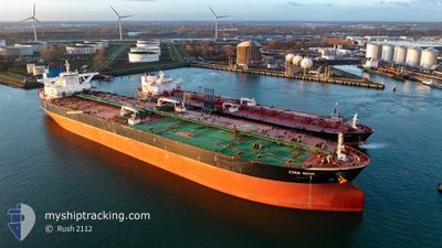
CYAN NOVA
Crude Oil Tanker
Current Trip
USG FOR ORDERS
| Time Travelled | 38 days |
|---|---|
| Remaining Time | --- |
| Distance Travelled | 5930.87 nm |
| Remaining Distance | --- |
| AVG Speed | 8.2 Noeuds |
| MAX Speed | 15.2 Noeuds |
| AVG Wind | 10.6 knots |
| MAX Wind | 32 knots |
| MIN Temp | 3.9°C / 39.02°F |
| MAX Temp | 26.3°C / 79.34°F |
| Tirant d eau | 11.2 m |
| Position reçue | 1 d depuis |
Current Position
| Longitude | --- |
|---|---|
| Latitude | --- |
| Etat | At anchor |
| Vitesse | |
| Parcours | 39° |
| Zone | Gulf of Mexico |
| Station | T-AIS |
| Position reçue | 1 d depuis |
Info
Information
The current position of CYAN NOVA is in Gulf of Mexico with coordinates 29.07463° / -94.71598° as reported on 2025-02-16 06:09 by AIS to our vessel tracker app. The vessel's current speed is 0 Noeuds
The vessel CYAN NOVA (IMO: 9534004, MMSI: 636020369) is a Crude Oil Tanker that was built in 2011 ( 14 Age ). It's sailing under the flag of [LR] Liberia.
In this page you can find informations about the vessels current position, last detected port calls, and current voyage information. If the vessels is not in coverage by AIS you will find the latest position.
The current position of CYAN NOVA is detected by our AIS receivers and we are not responsible for the reliability of the data. The last position was recorded while the vessel was in Coverage by the Ais receivers of our vessel tracking app.
The current draught of CYAN NOVA as reported by AIS is 11.2 meters
Weather
| Temperature | 11.7°C / 53.06°F |
|---|---|
| Wind Speed | 16 knots |
| Direction | 64° ENE |
| Pressure | 1024 hPa |
| Humidity | 66.2 % |
| Cloud Coverage | --- |
Featured Company
Most Visited Ports (Last year)
| Port | Arrivals | |
|---|---|---|
| 2 | ||
| 2 | ||
| 1 | ||
| 1 | ||
| 1 |
Events
| Heure | Evenement | Détails | Position/ Destination | Info |
|---|---|---|---|---|
| 2025-02-16 06:15 | Etat Changé | Default At anchor |
29.07482 / -94.71611
USG FOR ORDERS
|
Vitesse: Parcours: 39° |
| 2025-02-16 06:09 | Hors de la zone couverte |
29.07463 / -94.71598
Gulf of Mexico
|
Vitesse: Parcours: 288° |
|
| 2025-02-16 05:57 | Etat Changé | At anchor Default |
29.07448 / -94.71591
USG FOR ORDERS
|
Vitesse: Parcours: 42° |
| 2025-02-16 05:49 | Etat Changé | Default At anchor |
29.07470 / -94.71619
USG FOR ORDERS
|
Vitesse: 0.1 kn Parcours: 60° |
| 2025-02-16 05:45 | Etat Changé | At anchor Default |
29.07490 / -94.71643
USG FOR ORDERS
|
Vitesse: Parcours: 77° |
| 2025-02-16 05:21 | Etat Changé | Default At anchor |
29.07580 / -94.71670
USG FOR ORDERS
|
Vitesse: Parcours: 95° |
| 2025-02-16 05:12 | Etat Changé | At anchor Default |
29.07609 / -94.71677
USG FOR ORDERS
|
Vitesse: Parcours: 100° |
| 2025-02-16 04:54 | Etat Changé | Default At anchor |
29.07637 / -94.71679
USG FOR ORDERS
|
Vitesse: Parcours: 106° |
| 2025-02-16 04:48 | Etat Changé | At anchor Default |
29.07643 / -94.71677
USG FOR ORDERS
|
Vitesse: 0.1 kn Parcours: 106° |
| 2025-02-16 04:45 | Etat Changé | Default At anchor |
29.07650 / -94.71671
USG FOR ORDERS
|
Vitesse: 0.1 kn Parcours: 103° |