
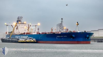
COSRISING LAKE
Tanker
Current Trip
| Time Travelled | 16 days |
|---|---|
| Remaining Time | --- |
| Distance Travelled | 5038.33 nm |
| Remaining Distance | --- |
| AVG Speed | 12.7 Noeuds |
| MAX Speed | 16.7 Noeuds |
| AVG Wind | 10.1 knots |
| MAX Wind | 22.8 knots |
| MIN Temp | 13.6°C / 56.48°F |
| MAX Temp | 30.8°C / 87.44°F |
| Tirant d eau | 11 m |
| Position reçue | 7 d depuis |
Current Position
| Longitude | 103.44325° |
|---|---|
| Latitude | 1.23274° |
| Etat | Under way using engine |
| Vitesse | 15.2 Noeuds |
| Parcours | 288.6° |
| Zone | Malacca Strait |
| Station | T-AIS |
| Position reçue | 7 d depuis |
Info
Information
The current position of COSRISING LAKE is in Malacca Strait with coordinates 1.23274° / 103.44325° as reported on 2024-05-16 03:25 by AIS to our vessel tracker app. The vessel's current speed is 15.2 Noeuds and is heading at the port of CABINDA. The estimated time of arrival as calculated by MyShipTracking vessel tracking app is 2024-06-10 13:00 LT
The vessel COSRISING LAKE (IMO: 9735737, MMSI: 477850600) is a Tanker It's sailing under the flag of [HK] Hong Kong.
In this page you can find informations about the vessels current position, last detected port calls, and current voyage information. If the vessels is not in coverage by AIS you will find the latest position.
The current position of COSRISING LAKE is detected by our AIS receivers and we are not responsible for the reliability of the data. The last position was recorded while the vessel was in Coverage by the Ais receivers of our vessel tracking app.
The current draught of COSRISING LAKE as reported by AIS is 11 meters
Weather
| Temperature | 27.2°C / 80.96°F |
|---|---|
| Wind Speed | 15 knots |
| Direction | 126° SE |
| Pressure | 1009.7 hPa |
| Humidity | 75.1 % |
| Cloud Coverage | 12 % |
Featured Company
Most Visited Ports (Last year)
| Port | Arrivals | |
|---|---|---|
| 2 | ||
| 1 | ||
| 1 | ||
| 1 |
Events
| Heure | Evenement | Détails | Position/ Destination | Info |
|---|---|---|---|---|
| 2024-05-16 03:33 | Etat Changé | Default Under way using engine |
1.24851 / 103.41434
CABINDA
|
Vitesse: 15.2 kn Parcours: 288.6° |
| 2024-05-16 03:25 | Hors de la zone couverte |
1.23274 / 103.44325
Malacca Strait
CABINDA
|
Vitesse: 15.2 kn Parcours: 288.6° |
|
| 2024-05-16 03:22 | Changement de zone | Malaysian part of the Malacca Strait Malaysian part of the Singapore Strait |
1.22921 / 103.45361
Malacca Strait
CABINDA
|
Vitesse: 15.2 kn Parcours: 288.8° |
| 2024-05-16 03:21 | Etat Changé | Under way using engine Default |
1.22809 / 103.45767
CABINDA
|
Vitesse: 15.1 kn Parcours: 285° |
| 2024-05-16 03:21 | Etat Changé | Default Under way using engine |
1.22734 / 103.46052
CABINDA
|
Vitesse: 15.1 kn Parcours: 285.3° |
| 2024-05-16 02:49 | Changement de zone | Malaysian part of the Singapore Strait Indonesian part of the Singapore Strait |
1.20233 / 103.58585
Singapore Strait
CABINDA
|
Vitesse: 14.2 kn Parcours: 285.6° |
| 2024-05-16 02:25 | Changement de zone | Indonesian part of the Singapore Strait Singaporean part of the Singapore Strait |
1.17759 / 103.67330
Singapore Strait
CABINDA
|
Vitesse: 13.8 kn Parcours: 300.9° |
| 2024-05-15 23:55 | Changement de zone | Singaporean part of the Singapore Strait Malaysian part of the Singapore Strait |
1.30536 / 104.05712
Singapore Strait
CABINDA
|
Vitesse: 7.3 kn Parcours: 217.8° |
| 2024-05-15 23:44 | Démarrage | 3.03 nm, East of TANAH MERAH |
1.32088 / 104.06756
CABINDA
|
Vitesse: 3.1 kn Parcours: 219° |
| 2024-05-15 23:39 | Changement de destination | CABINDA SGP PJSB |
1.32148 / 104.06985
CABINDA
|
Vitesse: 0.5 kn Parcours: 274° |