

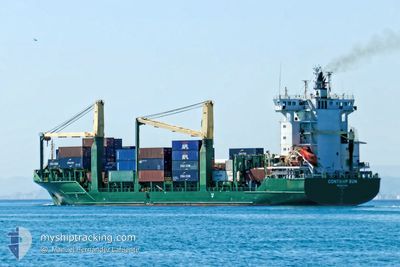
CONTSHIP SUN
Cargo

Current Trip
DZAAE
| Time Travelled | 1 day |
|---|---|
| Remaining Time | --- |
| Distance Travelled | 374.36 nm |
| Remaining Distance | --- |
| AVG Speed | 12.1 Noeuds |
| MAX Speed | 13.5 Noeuds |
| AVG Wind | 7.7 knots |
| MAX Wind | 11.7 knots |
| MIN Temp | 13.5°C / 56.3°F |
| MAX Temp | 15.6°C / 60.08°F |
| Tirant d eau | 8.8 m |
| Position reçue | 2 h, 9 m depuis |
Current Position
| Longitude | --- |
|---|---|
| Latitude | --- |
| Etat | Under way using engine |
| Vitesse | 12.7 Noeuds |
| Parcours | 128.8° |
| Zone | Mediterranean Sea - Eastern Basin |
| Station | T-AIS |
| Position reçue | 2 h, 9 m depuis |
Information
The current position of CONTSHIP SUN is in Mediterranean Sea - Eastern Basin with coordinates 35.65411° / 14.16122° as reported on 2025-02-28 17:10 by AIS to our vessel tracker app. The vessel's current speed is 12.7 Noeuds
The vessel CONTSHIP SUN (IMO: 9347815, MMSI: 636017894) is a Cargo It's sailing under the flag of [LR] Liberia.
In this page you can find informations about the vessels current position, last detected port calls, and current voyage information. If the vessels is not in coverage by AIS you will find the latest position.
The current position of CONTSHIP SUN is detected by our AIS receivers and we are not responsible for the reliability of the data. The last position was recorded while the vessel was in Coverage by the Ais receivers of our vessel tracking app.
The current draught of CONTSHIP SUN as reported by AIS is 8.8 meters
Weather
| Temperature | 15.3°C / 59.54°F |
|---|---|
| Wind Speed | 10 knots |
| Direction | 173° S |
| Pressure | 1021.4 hPa |
| Humidity | 72.3 % |
| Cloud Coverage | 100 % |


Featured Company
Last Port Calls
| Port | Arrival | Departure | Time In Port |
|---|---|---|---|
| 2025-02-23 09:56 | 2025-02-27 11:46 | 4 d | |
| 2025-02-20 19:11 | 2025-02-22 01:38 | 1 d | |
| 2025-02-13 16:49 | 2025-02-18 12:06 | 4 d | |
| 2025-02-11 23:31 | 2025-02-12 22:42 | 23 h | |
| 2025-02-08 14:35 | 2025-02-09 10:31 | 19 h | |
| 2025-02-04 10:27 | 2025-02-04 23:07 | 12 h | |
| 2025-02-03 18:41 | 2025-02-04 03:37 | 8 h | |
| 2025-02-02 05:58 | 2025-02-02 18:18 | 12 h | |
| 2025-01-31 11:37 | 2025-01-31 20:45 | 9 h | |
| 2025-01-29 21:55 | 2025-01-31 01:59 | 1 d |
Last Trips
| Origin | Departure | Destination | Arrival | Distance | |
|---|---|---|---|---|---|
| 2025-02-22 01:38 | 2025-02-23 09:56 | 372.14 nm | |||
| 2025-02-18 12:06 | 2025-02-20 19:11 | 261.66 nm | |||
| 2025-02-12 22:42 | 2025-02-13 16:49 | 187.98 nm | |||
| 2025-02-09 10:31 | 2025-02-11 23:31 | 637.46 nm | |||
| 2025-02-04 23:07 | 2025-02-08 14:35 | 115.72 nm | |||
| 2025-02-04 03:37 | 2025-02-04 10:27 | 75.60 nm | |||
| 2025-02-02 18:18 | 2025-02-03 18:41 | 304.21 nm | |||
| 2025-01-31 20:45 | 2025-02-02 05:58 | 248.98 nm | |||
| 2025-01-31 01:59 | 2025-01-31 11:37 | 112.54 nm | |||
| 2025-01-25 22:25 | 2025-01-29 21:55 | 544.29 nm |
Events
| Heure | Evenement | Détails | Position/ Destination | Info |
|---|---|---|---|---|
| 2025-02-28 17:16 | Etat Changé | Default Under way using engine |
35.64150 / 14.18036
DZAAE
|
Vitesse: 12.7 kn Parcours: 128.8° |
| 2025-02-28 17:10 | Hors de la zone couverte |
35.65411 / 14.16122
Mediterranean Sea - Eastern Basin
|
Vitesse: 12.7 kn Parcours: 128.8° |
|
| 2025-02-28 16:48 | Etat Changé | Under way using engine Default |
35.70292 / 14.08721
DZAAE
|
Vitesse: 12.7 kn Parcours: 129° |
| 2025-02-28 16:28 | Dans la zone couverte |
35.70292 / 14.08721
Mediterranean Sea - Eastern Basin
|
Vitesse: 12.7 kn Parcours: 128.7° |
|
| 2025-02-27 10:46 | PORT DE DEPART |
|
36.92079 / 7.89200
DZAAE
|
Vitesse: 4.6 kn Parcours: 120° |
| 2025-02-27 10:42 | Démarrage |
36.90266 / 7.78137
[DZ] ANNABA
|
Vitesse: 4.6 kn Parcours: 120° |
|
| 2025-02-23 09:17 | Arret |
36.89480 / 7.76267
[DZ] ANNABA
|
Vitesse: 0.1 kn Parcours: 268° |
|
| 2025-02-23 08:56 | Port d'arrivée |
|
36.90106 / 7.77350
[DZ] ANNABA
|
Vitesse: 4.1 kn Parcours: 266° |
| 2025-02-23 08:40 | Démarrage | 0.75 nm, East of ANNABA |
36.90264 / 7.79373
DZAAE
|
Vitesse: 3.8 kn Parcours: 219° |
| 2025-02-23 08:27 | Arret | 1.29 nm, East of ANNABA |
36.90676 / 7.80511
DZAAE
|
Vitesse: 0.3 kn Parcours: 254° |