

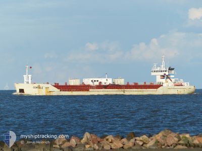
CEMVALE
Cement Carrier

Current Trip
| Trip Time | 1 day |
|---|---|
| Trip Distance | 388.19 nm |
| AVG Speed | 9.2 Noeuds |
| MAX Speed | 12.2 Noeuds |
| Tirant d eau | 6.1 m |
| AVG Wind | 7.3 knots |
| MAX Wind | 14 knots |
| MIN Temp | 4.8°C / 40.64°F |
| MAX Temp | 10.8°C / 51.44°F |
| Position reçue | Maintenant |
Current Position
| Longitude | --- |
|---|---|
| Latitude | --- |
| Etat | Moored |
| Vitesse | |
| Parcours | 160° |
| Zone | North Sea |
| Station | T-AIS |
| Position reçue | Maintenant |
Information
The current position of CEMVALE is in North Sea with coordinates 51.46002° / 0.34275° as reported on 2025-03-27 14:56 by AIS to our vessel tracker app. The vessel's current speed is 0 Noeuds and is currently inside the port of TILBURY.
The vessel CEMVALE (IMO: 9048287, MMSI: 212109000) is a Cement Carrier that was built in 1992 ( 33 Age ). It's sailing under the flag of [CY] Cyprus.
In this page you can find informations about the vessels current position, last detected port calls, and current voyage information. If the vessels is not in coverage by AIS you will find the latest position.
The current position of CEMVALE is detected by our AIS receivers and we are not responsible for the reliability of the data. The last position was recorded while the vessel was in Coverage by the Ais receivers of our vessel tracking app.
The current draught of CEMVALE as reported by AIS is 4.5 meters
Weather
| Temperature | 16.9°C / 62.42°F |
|---|---|
| Wind Speed | 7 knots |
| Direction | 232° SW |
| Pressure | 1018.5 hPa |
| Humidity | 52.1 % |
| Cloud Coverage | 5 % |


Featured Company
Last Port Calls
| Port | Arrival | Departure | Time In Port |
|---|---|---|---|
| 2025-03-26 10:49 | |||
| 2025-03-23 23:20 | 2025-03-24 19:01 | 19 h | |
| 2025-03-20 23:46 | 2025-03-22 20:22 | 1 d | |
| 2025-03-20 06:19 | 2025-03-20 06:22 | 3 m | |
| 2025-03-16 22:05 | 2025-03-19 08:09 | 2 d | |
| 2025-03-13 19:11 | 2025-03-15 06:48 | 1 d | |
| 2025-03-11 15:21 | 2025-03-12 15:31 | 1 d | |
| 2025-03-08 06:28 | 2025-03-10 22:39 | 2 d | |
| 2025-03-08 05:13 | 2025-03-08 05:37 | 23 m | |
| 2025-03-05 00:55 | 2025-03-06 09:50 | 1 d |
Last Trips
| Origin | Departure | Destination | Arrival | Distance | |
|---|---|---|---|---|---|
| 2025-03-24 19:01 | 2025-03-26 10:49 | 388.19 nm | |||
| 2025-03-22 20:22 | 2025-03-23 23:20 | 227.53 nm | |||
| 2025-03-20 06:22 | 2025-03-20 23:46 | 179.17 nm | |||
| 2025-03-19 08:09 | 2025-03-20 06:19 | 166.20 nm | |||
| 2025-03-15 06:48 | 2025-03-16 22:05 | 397.52 nm | |||
| 2025-03-12 15:31 | 2025-03-13 19:11 | 233.54 nm | |||
| 2025-03-10 22:39 | 2025-03-11 15:21 | 153.63 nm | |||
| 2025-03-08 05:37 | 2025-03-08 06:28 | 0.57 nm | |||
| 2025-03-06 09:50 | 2025-03-08 05:13 | 387.63 nm | |||
| 2025-03-02 15:38 | 2025-03-05 00:55 | 411.02 nm |
Events
| Heure | Evenement | Détails | Position/ Destination | Info |
|---|---|---|---|---|
| 2025-03-26 12:14 | Tirant d'eau modifié | 4.5 6.1 |
51.46003 / .34270
[GB] TILBURY
|
Vitesse: Parcours: 159° |
| 2025-03-26 12:13 | Etat Changé | Moored Under way using engine |
51.46003 / .34268
[GB] TILBURY
|
Vitesse: Parcours: 159° |
| 2025-03-26 12:12 | Changement de destination | DEBRB GBTIL |
51.46005 / .34266
[GB] TILBURY
|
Vitesse: Parcours: 159° |
| 2025-03-26 12:12 | Changement d'ETA | 2025/03/29 08:00 2025/03/26 12:00 |
51.46005 / .34266
[GB] TILBURY
|
Vitesse: Parcours: 159° |
| 2025-03-26 11:11 | Arret |
51.45302 / .33842
[GB] TILBURY
|
Vitesse: 0.3 kn Parcours: 339° |
|
| 2025-03-26 10:49 | Port d'arrivée |
|
51.44956 / .36287
[GB] TILBURY
|
Vitesse: 5 kn Parcours: 268.6° |
| 2025-03-26 02:00 | Etat Changé | Under way using engine Default |
51.83905 / 2.40381
GBTIL
|
Vitesse: 10.2 kn Parcours: 232° |
| 2025-03-26 01:58 | Etat Changé | Default Under way using engine |
51.84373 / 2.41329
GBTIL
|
Vitesse: 10.2 kn Parcours: 231.7° |
| 2025-03-26 01:27 | Detecté en mer | United Kingdom part of the North Sea |
51.89761 / 2.52243
North Sea
GBTIL
|
Vitesse: 10.1 kn Parcours: 231.6° |
| 2025-03-26 01:27 | Etat Changé | Under way using engine Default |
51.89761 / 2.52243
GBTIL
|
Vitesse: 10.1 kn Parcours: 232° |