

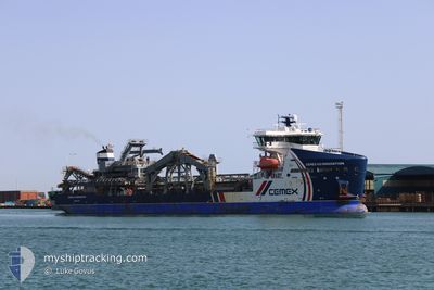
CEMEX GO INNOVATION
Dredging or underwater ops

Current Trip
DREDGEA340>===GB SHO
| Time Travelled | 18 h, 4 mins |
|---|---|
| Remaining Time | --- |
| Distance Travelled | 69.88 nm |
| Remaining Distance | --- |
| AVG Speed | 7.7 Noeuds |
| MAX Speed | 12.1 Noeuds |
| AVG Wind | 9.3 knots |
| MAX Wind | 16.7 knots |
| MIN Temp | 3.2°C / 37.76°F |
| MAX Temp | 7.6°C / 45.68°F |
| Tirant d eau | 5.6 m |
| Position reçue | 3 m depuis |
Current Position
| Longitude | --- |
|---|---|
| Latitude | --- |
| Etat | At anchor |
| Vitesse | 0.1 Noeuds |
| Parcours | 49° |
| Zone | English Channel |
| Station | T-AIS |
| Position reçue | 3 m depuis |
Information
The current position of CEMEX GO INNOVATION is in English Channel with coordinates 50.76941° / -0.26115° as reported on 2025-03-15 05:06 by AIS to our vessel tracker app. The vessel's current speed is 0.1 Noeuds
The vessel CEMEX GO INNOVATION (IMO: 9848675, MMSI: 232027481) is a Dredging or underwater ops It's sailing under the flag of [GB] United Kingdom.
In this page you can find informations about the vessels current position, last detected port calls, and current voyage information. If the vessels is not in coverage by AIS you will find the latest position.
The current position of CEMEX GO INNOVATION is detected by our AIS receivers and we are not responsible for the reliability of the data. The last position was recorded while the vessel was in Coverage by the Ais receivers of our vessel tracking app.
The current draught of CEMEX GO INNOVATION as reported by AIS is 5.6 meters
Weather
| Temperature | 3.3°C / 37.94°F |
|---|---|
| Wind Speed | 16 knots |
| Direction | 24° NNE |
| Pressure | 1019.1 hPa |
| Humidity | 83.3 % |
| Cloud Coverage | 11 % |


Featured Company
Last Port Calls
| Port | Arrival | Departure | Time In Port |
|---|---|---|---|
| 2025-03-13 22:21 | 2025-03-14 11:06 | 12 h | |
| 2025-03-12 10:47 | 2025-03-12 20:18 | 9 h | |
| 2025-03-09 19:30 | 2025-03-11 09:28 | 1 d | |
| 2025-03-08 16:23 | 2025-03-08 22:10 | 5 h | |
| 2025-03-07 15:11 | 2025-03-07 20:53 | 5 h | |
| 2025-03-05 08:27 | 2025-03-05 20:45 | 12 h | |
| 2025-03-04 07:38 | 2025-03-04 19:18 | 11 h | |
| 2025-03-02 10:11 | 2025-03-02 16:32 | 6 h | |
| 2025-03-01 09:51 | 2025-03-01 15:48 | 5 h | |
| 2025-02-27 22:06 | 2025-02-28 23:16 | 1 d |
Most Visited Ports (Last year)
| Port | Arrivals | |
|---|---|---|
| 87 | ||
| 86 | ||
| 11 | ||
| 4 | ||
| 2 | ||
| 2 |
Last Trips
| Origin | Departure | Destination | Arrival | Distance | |
|---|---|---|---|---|---|
| 2025-03-12 20:18 | 2025-03-13 22:21 | 144.20 nm | |||
| 2025-03-11 09:28 | 2025-03-12 10:47 | 88.05 nm | |||
| 2025-03-08 22:10 | 2025-03-09 19:30 | 84.64 nm | |||
| 2025-03-07 20:53 | 2025-03-08 16:23 | 54.91 nm | |||
| 2025-03-05 20:45 | 2025-03-07 15:11 | 330.50 nm | |||
| 2025-03-04 19:18 | 2025-03-05 08:27 | 55.52 nm | |||
| 2025-03-02 16:32 | 2025-03-04 07:38 | 367.88 nm | |||
| 2025-03-01 15:48 | 2025-03-02 10:11 | 48.81 nm | |||
| 2025-02-28 23:16 | 2025-03-01 09:51 | 78.23 nm | |||
| 2025-02-26 21:08 | 2025-02-27 22:06 | 113.51 nm |
Events
| Heure | Evenement | Détails | Position/ Destination | Info |
|---|---|---|---|---|
| 2025-03-14 20:42 | Etat Changé | At anchor Under way using engine |
50.76908 / -.25972
DREDGEA340>===GB SHO
|
Vitesse: 0.6 kn Parcours: 300° |
| 2025-03-14 20:34 | Arret | 3.48 nm, South of SHOREHAM |
50.77021 / -.26019
DREDGEA340>===GB SHO
|
Vitesse: 0.1 kn Parcours: 49° |
| 2025-03-14 20:03 | Changement de destination | DREDGEA340>===GB SHO NAB 340>>===GB SHO |
50.73239 / -.34573
DREDGEA340>===GB SHO
|
Vitesse: 10.2 kn Parcours: 56° |
| 2025-03-14 20:03 | Changement d'ETA | 2025/03/15 10:30 2025/03/14 21:30 |
50.73239 / -.34573
DREDGEA340>===GB SHO
|
Vitesse: 10.2 kn Parcours: 56° |
| 2025-03-14 17:10 | Etat Changé | Under way using engine Restricted manoeuverability |
50.59466 / -1.02346
NAB 340>>===GB SHO
|
Vitesse: 3.4 kn Parcours: 96° |
| 2025-03-14 17:06 | Démarrage | 5.81 nm, South East of SANDOWN |
50.59547 / -1.02861
NAB 340>>===GB SHO
|
Vitesse: 3.1 kn Parcours: 96° |
| 2025-03-14 16:57 | Arret | 5.6 nm, South East of SANDOWN |
50.59591 / -1.03483
NAB 340>>===GB SHO
|
Vitesse: 0.3 kn Parcours: 49° |
| 2025-03-14 16:53 | Changement d'ETA | 2025/03/14 21:30 2025/03/14 14:30 |
50.59518 / -1.03196
NAB 340>>===GB SHO
|
Vitesse: 3.6 kn Parcours: 281° |
| 2025-03-14 16:47 | Démarrage | 6.02 nm, South East of SANDOWN |
50.59537 / -1.02184
NAB 340>>===GB SHO
|
Vitesse: 3.1 kn Parcours: 274° |
| 2025-03-14 15:44 | Arret | 5.5 nm, South East of SANDOWN |
50.59600 / -1.03782
NAB 340>>===GB SHO
|
Vitesse: 0.3 kn Parcours: 69° |